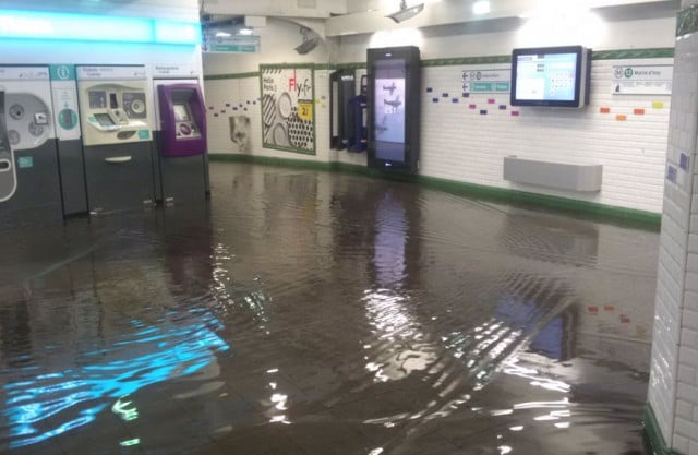
A violent two-hour storm struck the city late Sunday, forcing the closure of about 15 stations due to flooding.
Many stations reopened Monday morning and traffic began as normal, the Paris transport authority, the RATP, said.
But then the downpours returned again as more storms hit the capital, flooding roads and causing more Metro stations to close.
The whole of the capital was affected but the 15th and 13th arrondissements were said to be the hardest hit.
Three stations: Voltaire, Quai de la Rapée and Maubert-Mutualité were still closed on Monday morning, while Paris transport chiefs RATP said most services were running as normal although services on Line 6 may take a while to return to normal.
#orage #RATP pic.twitter.com/6F4HmKRinK
— Silvio Nuz (@silvionuz) July 10, 2017
#orage #paris #pluie pic.twitter.com/oZ1xoH43st
— Tiphanie Moreau (@tiphaniemoreau) July 9, 2017
Inondation dans le métro station porte d'Orléans #Paris #orage #boncourage #Inondation pic.twitter.com/EmzGetkFfo
— Kadia (@kadikadou) July 9, 2017
Les dix #photos et #vidéos qui montrent la puissance de l'#orage qui a inondé #Paris dimanche #metro https://t.co/xLJZR8kfjV pic.twitter.com/C9mBpbi0mN
— La Voix du Nord (@lavoixdunord) July 10, 2017
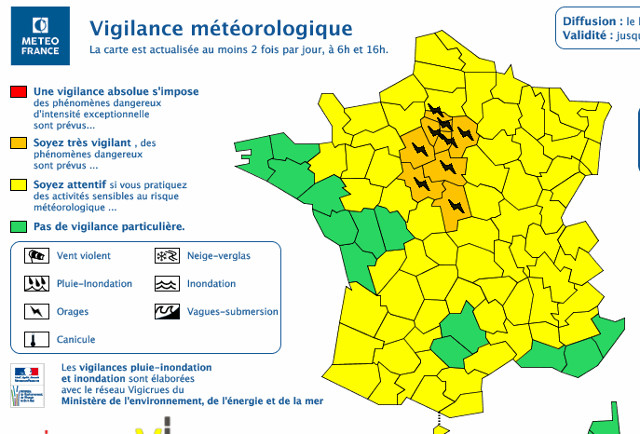
The national weather service Meteo France placed 12 departments (see map below, including those in the greater Paris region, on a 24-hour “orange alert” for heavy rains and electrical storms.
According to France's weather service Sunday night's downpour saw 50mm fall in an hour – the most rainfall in just one hour in the month of July since the year 1880.
Du coup pour la correspondance c'est pas gagné#orage #Montparnasse pic.twitter.com/PtVPxxoZ0k
— Flo (@fco6464) July 9, 2017
#Déluge à paris ! #metro pic.twitter.com/gp1W3HEsLW
— A. de Peretti (@AntoinedeP) July 9, 2017
The city fire brigade said it had received 1,700 emergency calls during the night and had intervened in 87 cases, mainly to pump out flooded cellars. They called on the public only to make calls if there was a real emergency.
Absolute torrential rainfall in Paris for last 30 mins. Thunder. Lightning. Then more Thunder. Mother nature clearly got the Sunday blues. pic.twitter.com/hI2DVub8jS
— Ben McPartland (@McPBen) July 9, 2017
On Monday people tried to make it to work although many were hampered by either flooded roads which made driving hazardous or closures to Metro stations.
Downpours in Paris. Metro stations and roads flooded and they still driving crazily pic.twitter.com/RsVKTFz5MG
— Ben McPartland (@McPBen) July 10, 2017
Bon courage pour soigner vos mycoses des pieds #orage ? pic.twitter.com/qTKugLRhPq
— laetitweet ? (@laetichtweet) July 10, 2017
8am – Chaussée d'Antin. #Paris #orage #flood #inondations pic.twitter.com/608kP7SZUf
— Jordi Bonabosch (@bonabosch) July 10, 2017
Underground car parks were flooded but firefighters were simply unable to deal with the amount of calls coming in.