SHARE
COPY LINK

WEATHER

Spain awaits first real snowfall of winter as flooding closes motorways

Weather alerts have been issued across Spain for rain, strong winds, waves, and even snow in parts of the northern peninsula.

Spain awaits first real snowfall of winter as flooding closes motorways
Two people walk in the snow after a snowfall in the northern Spanish Navarre village of Orreaga - Roncesvalles on January 10, 2024. (Photo by ANDER GILLENEA / AFP)

Spain is braced for its first significant snowfall of the winter with regions across the country on alert for strong winds and rain, with snowfall and wave surges forecast in some northern regions.

Heavy rain overnight in the Basque Country caused several rivers to overflow, mainly affecting the Vitoria area, and drivers were rescued from two vehicles in Navarre.

Weather forecast for Tuesday February 27th in Spain. Image: Aemet

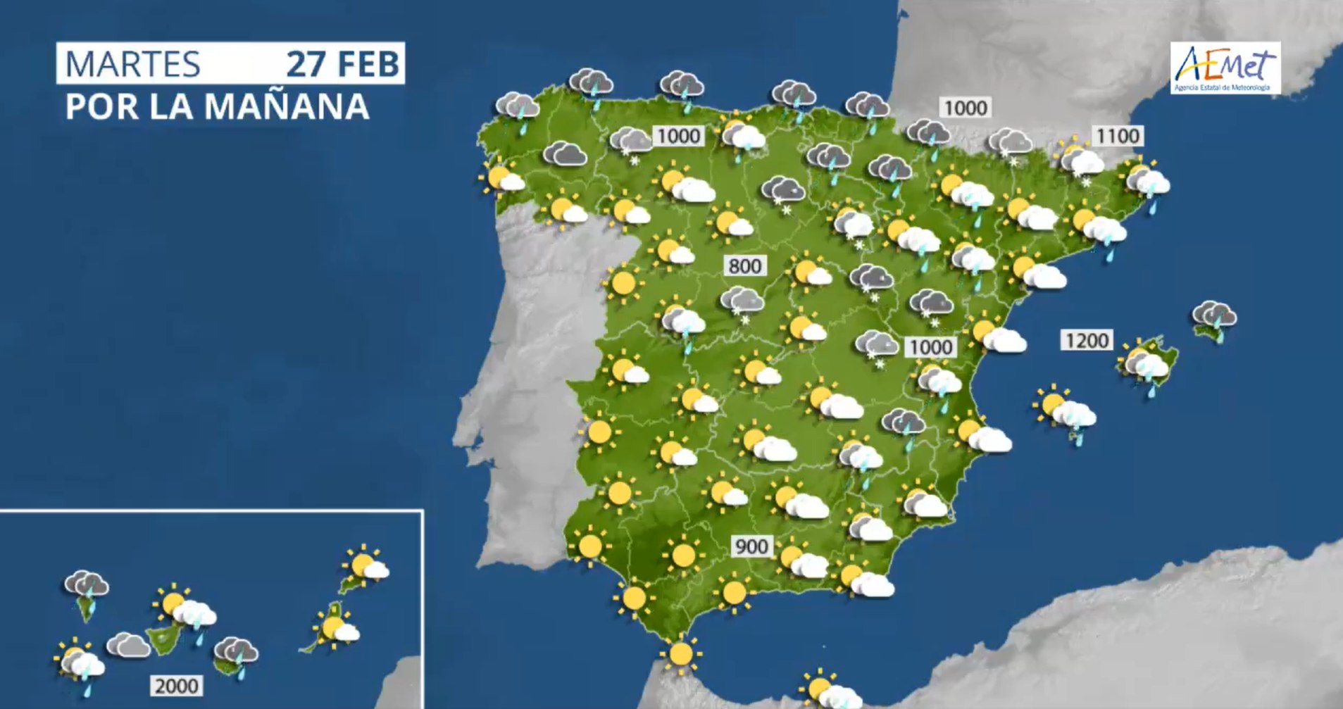
As of Tuesday morning every region of Spain, except Extremadura, remains on either a yellow warning (at risk) or orange warning (significant risk), for rains, winds, snow, or strong waves, according to forecasts from the state Meteorological Agency (Aemet).

The regions on orange alert are: Aragón, Asturias, the Balearic Islands, the Canary Islands, Cantabria, Castile and Leon, Catalonia, Navarre, the Basque Country and the Valencian Community.

Andalusia, Castile-La Mancha, Galicia, Madrid, Murcia, La Rioja and the autonomous city of Melilla are on yellow alert.

Temperatures are set to fall almost everywhere in the country, except in the far west of the peninsula, and could even fall below zero in places such as Teruel, Ávila, Segovia and Palencia.

So far at least 72 motorways are affected by the weather, especially roads in Asturias, León, Cantabria, Palencia, Burgos and Lugo, according to this live traffic map by Spain’s Dirección General de Tráfico (DGT).

Much of the snow is forecast to fall in mountainous areas, with a metre of snowfall predicted in the Cantabrian mountains, the Pyrenees and the Iberian system at elevations of 700-800 metres. In the Sierra Nevada and other southeastern mountain ranges light snow is forecast from 900 metres.

In Catalonia, an orange alert has been activated in Lleida for snow above 1,000 meters and there is a risk of avalanches.

In the Valencian Community, an orange level warning has been issued in Castellón for gusts between 90-100 km/h, and large parts of the peninsula could see winds of 70-80km/h.

In the Canary Islands, the orange alert particularly affects La Palma with maximum gusts of 90 km/h forecast. Strong winds are also expected in El Paso, though are forecast to affect the majority of the islands and cause strong waves.

Member comments

Log in here to leave a comment.
Become a Member to leave a comment.
For members

WEATHER

Does Spain use cloud seeding?

Some voices online blamed cloud seeding for flash flooding in Dubai recently. Does Spain use this weather modification technique and is it being harnessed as a means of combatting severe drought in the country?

Does Spain use cloud seeding?

The internet was awash with images of dramatic flooding in the UAE two weeks ago, in which parts of the country saw more rainfall in a single day than it usually does in an entire year on average.

The UEA government stated that it was the most rainfall the country had seen in 75 years and an incredible 10 inches of rain fell in the city of Al Ain.

Predictably, the freak weather event sparked fierce internet debate about the causes and consequences among climate change activists and climate change sceptics. The cause, in particular, struck a chord with certain subsections of the internet and many were asking the same question: did ‘cloud seeding’ cause this biblical downpour?

But what exactly is cloud seeding? Does Spain use it? And with the country’s ongoing drought conditions, should it be using it?

What is cloud seeding?

According to the Desert Research Institute: “Cloud seeding is a weather modification technique that improves a cloud’s ability to produce rain or snow by introducing tiny ice nuclei into certain types of subfreezing clouds. These nuclei provide a base for snowflakes to form. After cloud seeding takes place, the newly formed snowflakes quickly grow and fall from the clouds back to the surface of the Earth, increasing snowpack and streamflow.”

Cloud seeing is used by countries around the world, not only in the Middle East but in China and the U.S, usually in areas suffering drought concerns. The process can be done from the ground, with generators, or from above with planes.

Does Spain use cloud seeding?

Sort of, but on a far smaller scale and not in the same way other countries do. In places like China and the U.S, where large swathes of the country are at risk of drought, cloud seeding is used to help replenish rivers and reservoirs and implemented on an industrial scale.

In Spain, however, the technique has been for a much more specific (and small scale) reason: to avoid hailstorms that can destroy crops.

This has mostly been used in the regions of Madrid and Aragón historically.

But cloud seeding isn’t something new and innovative, despite how futuristic it might seem. In fact, Spain has a pretty long history when it comes to weather manipulation techniques. Between 1979 and 1981, the first attempts to stimulate rainfall took place in Spain, coordinated by the World Meteorological Organisation.

“In 1979, in Valladolid, different techniques were developed to observe the local clouds but they did not meet any possible conditions for cloud seeding experiments. The project came to a standstill,” José Luis Sánchez, professor of Applied Physics at the University of León, told La Vanguardia.

This sort of cloud seeding, as used abroad, doesn’t really happen in Spain anymore. Rather, when it’s used it’s done to protect crops on a local level. Spain’s Ministry for Ecological Transition and the Demographic Challenge are responsible for authorising cloud seeding, but there are only a handful of current authorisations to combat hail, such as the one granted to the Madrid’s Agricultural Chamber combat hail in the south-east of the region.

As of 2024, it is believed that no regions have requested cloud seeding (whether by generator or plane) to ‘produce’ more rain.

So, cloud seeding isn’t currently used like it is in countries such as the U.S., China, and the UAE. But should it, and could it solve the drought issue in Spain?

An aircraft technician inspects a plane’s wing mounted with burn-in silver iodide (dry ice) flare racks. (Photo by Indranil MUKHERJEE / AFP)

Spain’s drought conditions

Spain has been suffering drought conditions for several years now. Last year the government announced a multi-billion dollar package to combat the drought conditions, and several regions of Spain have brought in water restrictions to try and maintain dwindling reservoir reserves. 

READ ALSO:

At times in Spain in recent years it has felt as though another temperature or minimum rainfall record is broken every other day. The drought conditions are particularly bad in the southern region of Andalusia and Catalonia, where, despite heavy rain over Easter, reservoirs in the region are at just 18 percent capacity, the lowest level in the country.

So, could cloud seeding be used in Spain to help alleviate some of the drought conditions? Yes and no. Seeding is not the only answer to drought, but could theoretically be used as one option among many.

“It’s just another tool in the box,” Mikel Eytel, a water resources specialist with the Colorado River District, told Yale Environment 360 magazine: “It’s not the panacea that some people think it is.”

This is essentially because cloud seeding does not actually produce more rain, rather it stimulates water vapour already present in clouds to condense and fall faster. For there to be a significant amount of rainfall, the air needs significant levels of moisture.

That is to say, using cloud seeing to try and stimulate more rain may help Spain’s drought conditions in a small way, but the difference would be marginal.

“It’s not as simple and may not be as promising as people would like,” respected cloud physicist Professor William R. Cotton, wrote in The Conversation. 

“Experiments that produce snow or rain require the right type of clouds with sufficient moisture and the right temperature and wind conditions. The percentage increases are small and it is difficult to know when the snow or rain fell naturally and when it was triggered by seeding.”

SHOW COMMENTS