SHARE
COPY LINK

TRAVEL NEWS

Flights cancelled and trains disrupted after heavy snowfall in Munich

Munich airport reopened on Sunday after Saturday's heavy snowfall, but hundreds of flights have been cancelled and there are still no trains leaving the Bavarian city's main station.

This 2021 file photo shows a man in high-visibility clothing walking over snow-covered railtracks in a freight railway yard in Munich.
This 2021 file photo shows a man in high-visibility clothing walking over snow-covered railtracks in a freight railway yard in Munich. Heavy snowfall in the city caused trains, flights and roads to grind to a halt on Saturday. / AFP / Christof STACHE

Munich airport said on its website that flights were able to resume from 6am on Sunday, but some 560 of around 880 scheduled flights have been cancelled, a spokesperson told German news agency DPA. 

The temporary stop to flights on Saturday impacted take-offs and landings at other airports, too.

Anyone due to fly on Sunday should check the status of their flight before travelling.

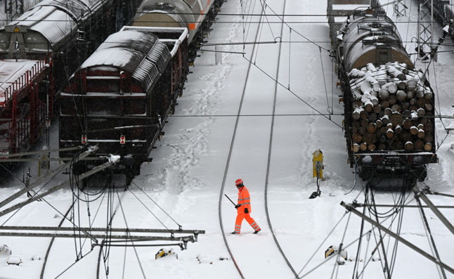
More than 40 centimetres of snow fell on Saturday, German weather services said, bringing trains in Munich and wider Bavaria to a stop.

READ ALSO: Heavy snow paralyses parts of southern Germany

No trains

Munich main station is expected to remain closed until at least 10am on Sunday, operator Deutsche Bahn said, asking travellers to postpone any non-urgent trips.

The railway wants to get trains up and running again as soon as possible, but this will only be on a few routes in the first instance and there will be fewer trains than normal, a spokesperson told DPA.

Travellers are still likely to face massive disruptions until at least Monday due to damaged infrastructure.

However, transport authorities said that bus, tram and suburban train services in Munich should resume on Sunday.

Traffic returned to normal on the roads in Bavaria overnight, however, with authorities only reporting minor incidents.

“A few trees fell down, but this only caused accidents with car body damage” a spokesman for the Upper Bavaria South police told DPA.

And in Lower Bavaria, a spokesperson said the number of accidents was also “typical for the time of year”.

The police said the night was similarly quiet on the streets in northern Upper Bavaria and Swabia.

Freezing temperatures 

The wintry weather didn’t just affect Bavaria either. The weather also impacted road travel in parts of northern Germany with one car in Mecklenburg-Vorpommern coming off a snow-covered road and hitting a tree. The driver and one passenger were seriously injured.

Further snowfall is not expected in most of Bavaria on Sunday, but the Eastern Central Uplands and the Alps may see several centimetres of fresh snow.

Forecasters are predicting lows of -6C to -9C on Sunday.

South of the Danube, temperatures could sink as low as -10C to -15C in some areas.

It’s set to remain cold on Monday and Tuesday with only sporadic snowfall.

It’s a similar picture for other parts of Germany, too: occasional snowfall is expected in Lower Saxony, on the North Sea coast and between the Ore Mountains and the Harz Mountains on Sunday.

On Monday, it’s forecast to turn to rain in those areas, but it should remain dry from Berlin to southern Bavaria.


Member comments

Log in here to leave a comment.
Become a Member to leave a comment.

WEATHER

Severe weather warnings issued as Germany braces for more storms

Extreme weather warnings for heavy rainfall remain in place in parts of Germany on Friday following flooding in the south. There is also a chance of thunderstorms at the weekend.

Severe weather warnings issued as Germany braces for more storms

Severe weather is expected in the southwest of the country on Friday, with the heaviest rain expected in Saarbrücken, as well as the surrounding areas of Saarland and southern Rhineland-Palatinate.

In these areas Germany’s weather service (DWD) has level 4 warnings in place – meaning that the rain is expected to be extremely heavy (more than 40 litres per square metre in an hour, or 60 litres per square metre in 6 hours).

Slightly less severe, but still heavy continuous rain can also be expected in the surrounding regions, extending as far as Stuttgart and Mainz.

Speaking to Bild newspaper, Climatologist Dr. Karsten Brandt suggested that the heavy precipitation and thunderstorms will continue to move northwest, even into southern North-Rhine Westphalia (Aachen).

There are also wind warnings in parts of the country, with squalls expected on the Brocken and the Fichtelberg mountains, as well as in the Black Forest and in the Alps.

Currently, the highest wind warnings are in Dresden and southern Bavaria near the Alps.

Friday’s weather warnings come in the wake of chaotic weather that flooded Nuremberg and parts of Bavaria Thursday night, where many roads flooded. Cars were submerged in water and bus routes were cancelled.

A number of household cellars also flooded as well as a large underground car park at the Technical University.

READ ALSO: Record heat deaths and floods – How Germany is being hit by climate change

What will the weekend bring?

Beyond the area of severe weather warnings but not beyond the reach of the storm, Cologne will have some rain on Friday which may continue on through the weekend.

Germany’s northern and eastern regions have dodged the recent bout of storms so far, but in Berlin scattered thunderstorms can be expected to move in by Sunday afternoon. This may put a dampener on the Karneval der Kulturen parade. 

In Bremen and Hamburg, residents can expect some rain showers on Sunday and Monday, with a chance of thunderstorms as well.

In Munich and Nuremberg, it looks as if the worst is over. Some small showers may continue into Saturday, but Bavarian residents can look forward to a sunny Sunday ahead of the public holiday on Monday for Pentecost. 

READ ALSO:

SHOW COMMENTS