SHARE
COPY LINK

WEATHER

Spain braces for possible tropical cyclone

After scorching summer temperatures, record-breaking droughts, wildfires across the country and deadly hail storms, Spain's extreme weather could be set to continue with a possible tropical cyclone.

Spain braces for possible tropical cyclone
Photo: Pixabay.

Spain has suffered its fair share of extreme weather this summer. Whether it be temperatures in the high forties during Spain’s ola de calora mini-tsunami in southern Spain, forest fires across the country, or a freak hail storm that killed a toddler recently, Spanish weather has been as unpredictable as it has extreme. 

READ MORE: WHO says heatwave caused 1,700 deaths in Spain and Portugal

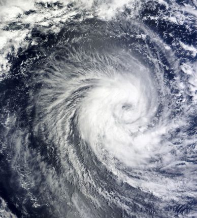
To further add to the summer of extreme weather, meteorologists are now predicting a possible tropical cyclone could be headed for the Spanish mainland. 

According to Spanish weather website eltiempo.es, an unstable area of pressure is currently sitting in the middle of the Atlantic Ocean at relatively high latitudes. Forecasts from various weather models suggest this zone could form a tropical storm.

The United States National Hurricane Center gives a 70 percent chance of a cyclone forming in the coming days.

READ MORE: VIDEO: ‘Mini tsunami’ shocks beachgoers in southern Spain

Models suggest that it would move slowly to the northeast, then turn eastward and move more quickly, picking up its maximum intensity, with the modelling forecasting that it could have the characteristics of a Category 1 hurricane from Tuesday of next week.

It is worth noting that although several models are predicting this, the possibility of whether the potential cyclone will affect Spain, or perhaps even reach the mainland, is not yet certain.

However, eltiempo.es states that “several of the main weather models indicate that the tropical cyclone could approach Spain on Thursday next week.”

This wouldn’t be the first tropical storm system to affect the Iberian Peninsula, however. In 2005, Hurricane Vince entered Spain as a tropical storm through the Gulf of Cadiz. And in 2018, the remains of Hurricane Leslie also reached Spain as a cyclone.

Effects

What happens if a cyclone does form? What happens if it approaches, or even enters, the Spanish mainland? If it were to move towards the northwest coast of the country, it is predicted to cause a strong burst of sustained southern wind.

It would also cause rough seas along Atlantic coast, as well as heavy rain.

If the potential cyclone approaches the mainland or even enters the peninsula, intense winds would likely be felt across the country, and there could ‘widespread instability’, according to eltiempo.es, with strong winds and rain.

Member comments

Log in here to leave a comment.
Become a Member to leave a comment.
For members

WEATHER

Does Spain use cloud seeding?

Some voices online blamed cloud seeding for flash flooding in Dubai recently. Does Spain use this weather modification technique and is it being harnessed as a means of combatting severe drought in the country?

Does Spain use cloud seeding?

The internet was awash with images of dramatic flooding in the UAE two weeks ago, in which parts of the country saw more rainfall in a single day than it usually does in an entire year on average.

The UEA government stated that it was the most rainfall the country had seen in 75 years and an incredible 10 inches of rain fell in the city of Al Ain.

Predictably, the freak weather event sparked fierce internet debate about the causes and consequences among climate change activists and climate change sceptics. The cause, in particular, struck a chord with certain subsections of the internet and many were asking the same question: did ‘cloud seeding’ cause this biblical downpour?

But what exactly is cloud seeding? Does Spain use it? And with the country’s ongoing drought conditions, should it be using it?

What is cloud seeding?

According to the Desert Research Institute: “Cloud seeding is a weather modification technique that improves a cloud’s ability to produce rain or snow by introducing tiny ice nuclei into certain types of subfreezing clouds. These nuclei provide a base for snowflakes to form. After cloud seeding takes place, the newly formed snowflakes quickly grow and fall from the clouds back to the surface of the Earth, increasing snowpack and streamflow.”

Cloud seeing is used by countries around the world, not only in the Middle East but in China and the U.S, usually in areas suffering drought concerns. The process can be done from the ground, with generators, or from above with planes.

Does Spain use cloud seeding?

Sort of, but on a far smaller scale and not in the same way other countries do. In places like China and the U.S, where large swathes of the country are at risk of drought, cloud seeding is used to help replenish rivers and reservoirs and implemented on an industrial scale.

In Spain, however, the technique has been for a much more specific (and small scale) reason: to avoid hailstorms that can destroy crops.

This has mostly been used in the regions of Madrid and Aragón historically.

But cloud seeding isn’t something new and innovative, despite how futuristic it might seem. In fact, Spain has a pretty long history when it comes to weather manipulation techniques. Between 1979 and 1981, the first attempts to stimulate rainfall took place in Spain, coordinated by the World Meteorological Organisation.

“In 1979, in Valladolid, different techniques were developed to observe the local clouds but they did not meet any possible conditions for cloud seeding experiments. The project came to a standstill,” José Luis Sánchez, professor of Applied Physics at the University of León, told La Vanguardia.

This sort of cloud seeding, as used abroad, doesn’t really happen in Spain anymore. Rather, when it’s used it’s done to protect crops on a local level. Spain’s Ministry for Ecological Transition and the Demographic Challenge are responsible for authorising cloud seeding, but there are only a handful of current authorisations to combat hail, such as the one granted to the Madrid’s Agricultural Chamber combat hail in the south-east of the region.

As of 2024, it is believed that no regions have requested cloud seeding (whether by generator or plane) to ‘produce’ more rain.

So, cloud seeding isn’t currently used like it is in countries such as the U.S., China, and the UAE. But should it, and could it solve the drought issue in Spain?

An aircraft technician inspects a plane’s wing mounted with burn-in silver iodide (dry ice) flare racks. (Photo by Indranil MUKHERJEE / AFP)

Spain’s drought conditions

Spain has been suffering drought conditions for several years now. Last year the government announced a multi-billion dollar package to combat the drought conditions, and several regions of Spain have brought in water restrictions to try and maintain dwindling reservoir reserves. 

READ ALSO:

At times in Spain in recent years it has felt as though another temperature or minimum rainfall record is broken every other day. The drought conditions are particularly bad in the southern region of Andalusia and Catalonia, where, despite heavy rain over Easter, reservoirs in the region are at just 18 percent capacity, the lowest level in the country.

So, could cloud seeding be used in Spain to help alleviate some of the drought conditions? Yes and no. Seeding is not the only answer to drought, but could theoretically be used as one option among many.

“It’s just another tool in the box,” Mikel Eytel, a water resources specialist with the Colorado River District, told Yale Environment 360 magazine: “It’s not the panacea that some people think it is.”

This is essentially because cloud seeding does not actually produce more rain, rather it stimulates water vapour already present in clouds to condense and fall faster. For there to be a significant amount of rainfall, the air needs significant levels of moisture.

That is to say, using cloud seeing to try and stimulate more rain may help Spain’s drought conditions in a small way, but the difference would be marginal.

“It’s not as simple and may not be as promising as people would like,” respected cloud physicist Professor William R. Cotton, wrote in The Conversation. 

“Experiments that produce snow or rain require the right type of clouds with sufficient moisture and the right temperature and wind conditions. The percentage increases are small and it is difficult to know when the snow or rain fell naturally and when it was triggered by seeding.”

SHOW COMMENTS