SHARE
COPY LINK

DISCOVER SWITZERLAND

Five beautiful Swiss villages located near Alpine lakes

During torrid summer days, why not come and cool off in one of these five alpine lakes? Set against a unique mountain backdrop, they are ideal for a trip out of the city no matter where you are in Switzerland.

Switzerland's Gänglesee. When the weather gets warmer, Swiss lakes are a perfect place to cool down. Picture: Christian Guerra/Swiss Villages

There will be no shortage of picnic areas, nooks and crannies for barbecuing with friends and hiking trails in the vicinity for discovering these idyllic areas.

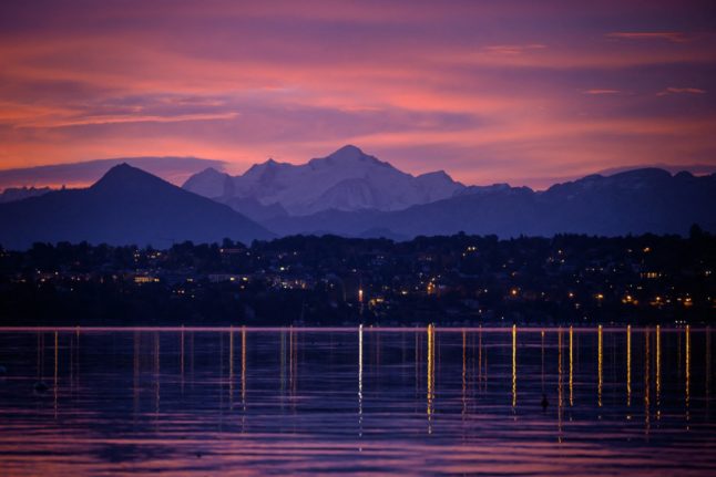
The following map shows the five lakes’ locations across Switzerland. 

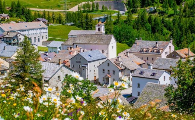
The lakes are close to five villages which are members of the association “Les plus beaux Villages de Suisse” (The most beautiful Villages in Switzerland), which aims to protect and promote villages that have a distinct architectural, landscape and historical beauty.

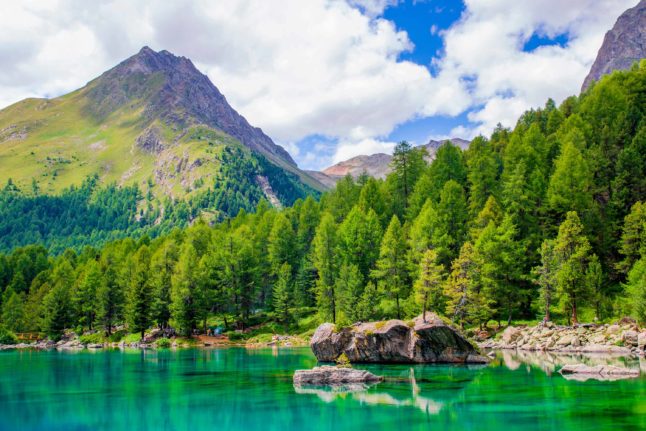
1. Lai da Palpuogna: Bergün (Gr)

Bergün is a charming village in Canton Graubünden set like a gem in Switzerland’s largest nature park, Parc Ela.

Its unique location between the Engadin and the Albula Pass has shaped the history, culture and architecture of the village.

Bergün. Picture: Christian Guerra/Swiss Villages

Bergün. Picture: Christian Guerra/Swiss Villages

Testimony to this are the typical Engadin houses decorated with the ‘sgraffito’ technique, the Kurhaus hotel that takes us back in time to the Belle Epoque and its Romanesque church, which houses an astonishing frescoed wooden ceiling.

And it is precisely on the Albula pass that we find the idyllic Lai da Palpuogna with its crystal-clear waters and a larch forest reflected in its changing colours. In a well-known Swiss television programme, this lake was voted the most beautiful place in Switzerland. 

Lai Palpuogna  Picture: Christian Guerra/Swiss Villages

Lai Palpuogna. Picture: Christian Guerra/Swiss Villages

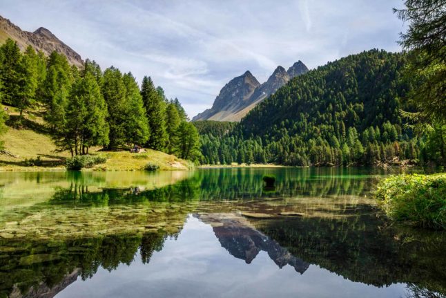
Starting point: Preda (train station) : 1 Km / 120 m difference in altitude / 20 minutes walk

2. Lag da Breil: Breil Brigels (Gr)

In the Surselva region, in the heart of the canton of Graubünden, we drive up the main road to Breil/Brigels.

This beautiful alpine village is a jigsaw puzzle of sumptuous wooden chalets and little churches, one more beautiful than the other, such as the church of St. Sievi, which stands in a panoramic position and is visible from everywhere.

Breil Brigels. Picture: Christian Guerra/Swiss Villages

Breil Brigels. Picture: Christian Guerra/Swiss Villages

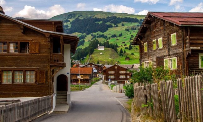
Here we are at the gateway to the Val Frisal, a fascinating side valley ideal for summer hiking.

Just a stone’s throw from the village centre, we find the Lag da Breil, a turquoise-coloured freshwater lake that invites tourists to relax on its shores.

There is a large car park, a mini-golf course, ski lifts and a playground right next to the lake… in short, all kinds of activities for everyone!

Lag da Breil  Picture: Christian Guerra/Swiss Villages

Lag da Breil. Picture: Christian Guerra/Swiss Villages

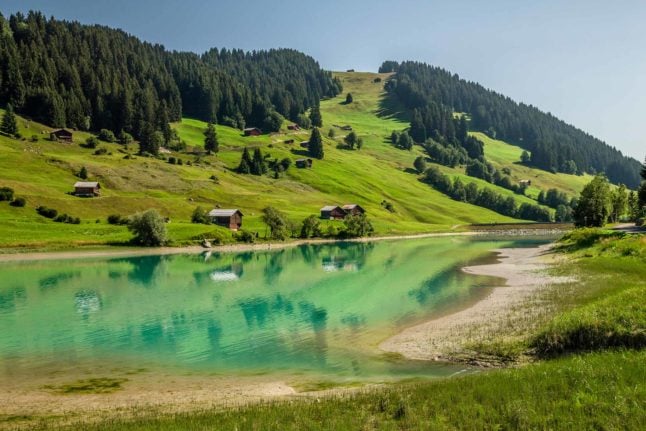
Starting point: Breil/Brigels (Church) : 900 M / 33 m difference in altitude / 10 minutes walk

3. Lago Saoseo: Poschiavo (Gr)

Poschiavo is a little Rome of the Alps, with its bell towers and opulent towers and an array of museums and state-of-the-art cultural spaces.

Poschiavo Picture: Christian Guerra/Swiss Villages

Poschiavo. Picture: Christian Guerra/Swiss Villages

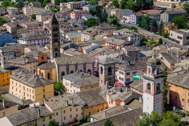
This small town in the Italian-speaking part of Switzerland has always been a key crossroads between Switzerland and Italy, and even today, the famous little red Bernina train links the two nations, travelling through glaciers, forests and wild mountains.

From the locality of Sfarzù, just a few minutes from Poschiavo, it is possible to walk or take the post bus up to Lake Saoseo. This Alpine lake is a concentration of unique beauty and is set like a jewel in a dense larch forest.

From here, with a little more effort, you can also reach the Lagh da Val Viola, a little larger in size but equally magnificent.

Lago Saoseo  Picture: Christian Guerra/Swiss Villages

Lago Saoseo. Picture: Christian Guerra/Swiss Villages

Starting point: Sfarzù (bus stop) : 5.5 km / 420 m difference in altitude / 1h30 minutes walk

4. Rotelschsee: Simplon Dorf (Vs)

The Simplon Pass has always been a key commercial junction for trade between northern and southern Europe, connecting Brig in Switzerland with Domodossola in Italy.

First Baron Stockalper, and then Napoleon Bonaparte, were able to create a road linking the two cities, and halfway along, the village of Simplon Dorf benefited. This ancient Italian-looking village contains an amazing square crowned by iconic buildings such as its museum.

Simplon Dorf Picture: Christian Guerra/Swiss Villages

Simplon Dorf. Picture: Christian Guerra/Swiss Villages

And it is precisely at the highest point of the Simplon Pass, at an altitude of around 2000m, that some very picturesque natural lakes have been created.

These include the Rotelschee lake, located just a few minutes behind the hospice, and the Hopschusee lake near the alpine pasture of the same name. 

Rotelschsee Picture: Christian Guerra/Swiss Villages

Rotelschsee. Picture: Christian Guerra/Swiss Villages

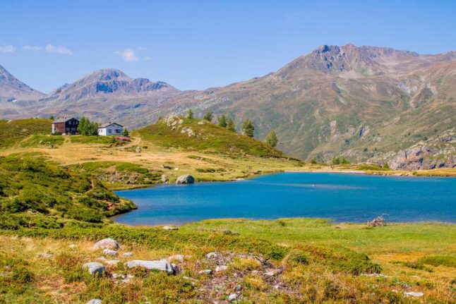
Starting point: Simplon Pass (Hospiz) : 700 m / 50 m difference in altitude / 10 minutes walk

5. Gänglesee: Triesenberg

The Principality of Liechtenstein shares not only language and currency with Switzerland, but also many traditions and peculiarities.

For example, the village of Triesenberg boasts a Walser past and even today, a different dialect is spoken here than in all the municipalities of the small country.

Triesenberg Picture: Christian Guerra/Swiss Villages

Triesenberg Picture: Christian Guerra/Swiss Villages

Since 2019, this village has been included in the Swiss network of ‘The most beautiful Villages in Switzerland. 

Gänglesee Picture: Christian Guerra/Swiss Villages

Gänglesee Picture: Christian Guerra/Swiss Villages

All these excursions, and many more feature in the Les plus beaux Villages de Suisse free to download app available in English for iOS and Android. 

To reach these magnificent freshwater lakes and much more, why not check out from ‘The most beautiful Villages in Switzerland‘?

Member comments

Log in here to leave a comment.
Become a Member to leave a comment.
For members

HIKING

The seven best hikes around Geneva

There are some great one day hikes within easy reach of the Swiss city of Geneva but some are easier than others, writes Monty Pierce Jones.

The seven best hikes around Geneva

When you walk across the Pont du Mont Blanc in the centre of Geneva you notice that you can’t actually see Mont Blanc itself. 

Instead, what catches your eye are a series of smaller, but no less iconic, mountains: Le Salève, Les Voirons, and Le Môle which make up the backdrop of Rive Gauche, and when looking the other way it is impossible to miss the Jura, with Crêt de la Neige and La Dôle being the more eye-catching summits of “Switzerland’s spine”.

These foothills hug the Geneva metropolitan area (forming la cuvette genevoise) – and other than trapping pollution, they offer some brilliant hiking for locals and visitors alike. 

Here are 7 of the best.

Le Salève

The Salève, is known as the balcony of Geneva. The main backdrop of this Swiss city is found in… France, like almost every other hike on this list. It feels like a great limestone wave about to crash onto you: the “French side” builds up slowly to the abrupt cliffs, striations, and quarry of the “Genevois side”. Frankenstein’s monster scales this perpendicular face in Mary Shelley’s book.

I’m not suggesting you follow in Frankenstein’s footsteps exactly, but you too can climb the Salève. Here are two recommended routes:

Via Le Pas de l’Échelle

This four and half hour, 4.4km hike offers an easier walk – but it’s not to be underestimated. Le Pas de l’Échelle is the historic way up the hill, its carved stone step sections attest to its 14th century roots. Park at the Gare de Départ of the Téléphérique (15 minute drive from Geneva’s centre, 40 minutes with a walk if you take the 8 bus) and head towards Chemin du Bois Meriguet. After an hour or so you’ll pass through the lovely village of Monnetier nestled between the Petit and Grand Salève – before reaching the “Panorama”, where you might catch a few paragliders taking off.

Via Chemin de la Grande Gorge

This is a more difficult hike – both longer and steeper than Le Pas de l’Échelle. As the name suggests, it follows the “big gorge” that cuts through this part of the Salève. It winds its way through the couloir before cutting left towards the “Panorama”. It is a more adventurous, secluded climb, and was apparently used by smugglers back in the day. Start from the same spots as Le Pas de l’Échelle.

You can go up one way and down the other to mix things up.

Get more info on trekking La Salève.

Le Signal des Voirons

Le Massif des Voirons (1,480 m) reaches higher than the more dramatic Salève (1,379 m) despite often being overshadowed by it.

This is an injustice, as getting to the top earns you the best 360 degree view on this list. Les Dents du Midi are viewable from the top. It is also wilder than Le Salève, so keep an eye out for orchids, chamois, and if you’re really lucky, a lynx.

Start from the Lac de Machilly parking (30 minutes by car) or the Machilly station (45 minutes by train via Annemasse) and head towards Chemin du Sauget. Turn right on Route du Seujet and you’ll find yourself at the signposted start of the five hour – 17 km loop of Les Voirons.

Le Môle

Le Môle sits further back from the city, but at 1,863 metres (the tallest mountain on this list) it is no molehill. In fact, it has one of the most recognisable silhouettes in the region: a near-perfect pyramid. It too was mentioned by Shelley in Frankenstein.

For an easy, sunny four hour – 9 km hike, drive 40 minutes to Saint-Jean-de-Tholome, park at Chez Beroud, and head towards the summit.

Petit Salève Loop

Park at the Château d’Etrembières (20 minute drive from the centre – can also take the 17 tram and walk). Head towards the forest and walk for around 2 hours hours. You will eventually reach the Camp des Allobroges near the summit. The Allobroges were the Celtic tribe that founded Geneva, they may even have helped Hannibal cross the Alps.

The remnants of their hillfort (or oppidum) – placed there as a symbol of control – are probably the best thing about the hike. The 6km loop should take you about four hours. On the way up you’ll have great views of Geneva and the Jura, and on the way back of Mont Blanc and the Môle.

Chemin de La Dôle

This hike is the only one on this list that is wholly in Switzerland, funnily enough. La Dôle is known for the iconic weather dome that you can easily spot from Le Jardin Anglais.

The views from the summits of the other hikes on this list, as wonderful as they are, do cross-over a fair amount: you can spot Le Môle from Les Voirons and vice versa; they all have great views of Geneva and the Massif du Mont Blanc.

La Dôle offers something different, you get a better sense of l’arc lémanique, and more expansive views of the alps (especially the Bernese and Chablais Alps). It is the furthest out from Geneva, at an hour by train or 45 minutes by car, but it’s worth it.

Le Chemin de La Dôle (SuisseMobile route 116) is a long but easy hike. You will likely walk 15km in 5 hours. You should start in La Givrine and end in St Cergue, though you can keep going to Nyon and in doing so complete the last stage of the Jura Crest Trail (SuisseMobile route 5).

Le Reculet + Crêt de la Neige

This is the hardest hike on this list, if you’re up to it you’ll reach the highest point in the Jura mountains. Le Reculet and Crêt de la Neige don’t jut out much from the Jura range but you can spot them from around the city. Next time you find yourself on one of the stops of the 12 tram in Rive Gauche, look up and you’ll realise that they are often framed by Geneva’s low-rise buildings.

It will take you 40 minutes by car to get to the trailhead (Tiocan, Thoiry), or 1h40 minutes by public transport (50 minutes to Thoiry – take the 18 tram and the 68 bus – and 50 minutes walk). Be prepared for a 13.5 km, 7 hour hike – and a view that encompasses every other peak on this list. It’s worth it.

Further reading:

The websites Monts de Geneve offers more info for treks in the area.

SHOW COMMENTS