
While rivers burst their banks across the country and several areas were hard hit, Vienna managed to escape the worst.
This week, the Danube (Donau) river is expected to flow over its banks, but instead of flooding Vienna’s historic streets, it will flow into the New Danube – the channel built in the 1970s to protect the city of Vienna.
Die "Neue Donau" wird überschwemmt, damit die Donau in Wien nicht übergeht. Dafür wurde die Neue Donau und die Donauinsel in den 1970er Jahren gebaut. pic.twitter.com/lJTQcBdV4c
— gerald krieghofer (@krieghofer) July 19, 2021
“The “New Danube” is flooded so that the Danube does not overflow in Vienna. The New Danube and the Danube Island were built in the 1970s for this purpose.”
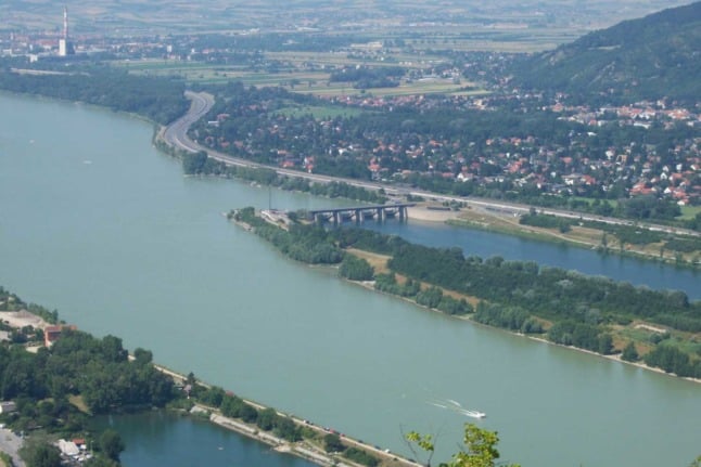
What is the New Danube?
The New Danube is a side channel built into the Danube River. The design of the channel was made in 1969, with construction taking place from 1972 to 1988.
The Donauinsel (Danube Island) is 21 kilometres long and now sits in the middle of the two waterways and was constructed from rocks and dirt dredged out of the river.
The International Knowledge Centre for Engineering Sciences and Technology reports that few areas of the city were protected from large floods.
“Vienna was over many centuries subject to severe flooding. Only the very oldest parts of town, where the Roman fort was once established were flood free.”
Catastrophic flooding events took place in 1897 and 1899, which led to smaller scale changes to try and reduce damage.
The idea for the channel gained momentum after 1954, when another catastrophic flood hit Vienna and authorities realised that a more drastic change was needed to properly protect the city from flooding.
How does it work?
At the entrance to the New Danube channel, there is an openable weir which stops water from the Danube from entering.
In normal times, the weir seals off the channel which makes it perfect for swimming and other water activities, while facilities were built on the land to allow for volleyball, skating, jogging and other activities.
Up to 300,000 people can use the area each day.
The weir is so popular some people use it to commute to work, giving it the nickname “the autobahn for swimmers”.
When the water level rises in the main river, the gates are released to reduce pressure on the main part of the river and allow water into the channel.
As has happened in 2021 with the high water levels, this will usually mean swimming, boating and other water activities are banned in the channel.
There are two other weirs further down in the channel which help to regulate water level during non-flood periods.


Member comments