SHARE
COPY LINK

WEATHER

Coldest night of year has Germans shivering, from Hamburg to Bavaria

The weathermen told us that it was going to be a cold night on Sunday. And sure enough, temperatures hit a low for the winter, from the Alps all the way up to the Baltic coast.

Coldest night of year has Germans shivering, from Hamburg to Bavaria
The Bismark memorial in Hamburg on Monday. Photo: DPA

The weather station at the summit of Zugspitze, at 2,962 metres Germany's tallest mountain, recorded a low of -27C on Sunday night, making it the chilliest night of the winter so far. February is the coldest month of the year of the snowy Alpine peak, with an average temperature of -11.4C.

Things weren't much warmer down in the flat lands, with temperatures ranging between -10C and -15C in much of the south and the east of the country.

SEE ALSO: Cold snap – lows of -20C set to hit Germany starting at weekend

In the northeast of the country, where temperatures were slightly higher, snow fell thick and fast. Residents of some districts of the capital Berlin woke up to find a dusting of snow covering the rooftops, while Hamburg also got a coating of white powder.

The German Weather Service (DWD) has forecast the cold snap to last until Tuesday evening.

The Feldberg in Baden-Württemberg on Sunday. Photo: DPA

A snow plough at work in Lübeck. Photo: DPA

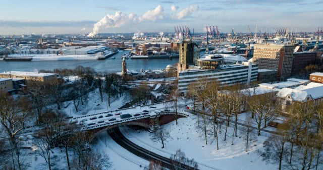
A snowy panorama in Hamburg. Photo: DPA

WEATHER

Severe weather warnings issued as Germany braces for more storms

Extreme weather warnings for heavy rainfall remain in place in parts of Germany on Friday following flooding in the south. There is also a chance of thunderstorms at the weekend.

Severe weather warnings issued as Germany braces for more storms

Severe weather is expected in the southwest of the country on Friday, with the heaviest rain expected in Saarbrücken, as well as the surrounding areas of Saarland and southern Rhineland-Palatinate.

In these areas Germany’s weather service (DWD) has level 4 warnings in place – meaning that the rain is expected to be extremely heavy (more than 40 litres per square metre in an hour, or 60 litres per square metre in 6 hours).

Slightly less severe, but still heavy continuous rain can also be expected in the surrounding regions, extending as far as Stuttgart and Mainz.

Speaking to Bild newspaper, Climatologist Dr. Karsten Brandt suggested that the heavy precipitation and thunderstorms will continue to move northwest, even into southern North-Rhine Westphalia (Aachen).

There are also wind warnings in parts of the country, with squalls expected on the Brocken and the Fichtelberg mountains, as well as in the Black Forest and in the Alps.

Currently, the highest wind warnings are in Dresden and southern Bavaria near the Alps.

Friday’s weather warnings come in the wake of chaotic weather that flooded Nuremberg and parts of Bavaria Thursday night, where many roads flooded. Cars were submerged in water and bus routes were cancelled.

A number of household cellars also flooded as well as a large underground car park at the Technical University.

READ ALSO: Record heat deaths and floods – How Germany is being hit by climate change

What will the weekend bring?

Beyond the area of severe weather warnings but not beyond the reach of the storm, Cologne will have some rain on Friday which may continue on through the weekend.

Germany’s northern and eastern regions have dodged the recent bout of storms so far, but in Berlin scattered thunderstorms can be expected to move in by Sunday afternoon. This may put a dampener on the Karneval der Kulturen parade. 

In Bremen and Hamburg, residents can expect some rain showers on Sunday and Monday, with a chance of thunderstorms as well.

In Munich and Nuremberg, it looks as if the worst is over. Some small showers may continue into Saturday, but Bavarian residents can look forward to a sunny Sunday ahead of the public holiday on Monday for Pentecost. 

READ ALSO:

SHOW COMMENTS