SHARE
COPY LINK

WEATHER

Paris on alert as River Seine breaks banks and keeps on rising

The River Seine in Paris has flooded and water levels just keep going up.

Paris on alert as River Seine breaks banks and keeps on rising
File pic: Beginning of January 2018/ AFP
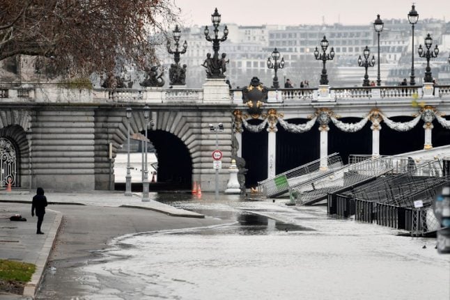
The river's water levels are now at 4.33 metres at the Pont d'Austerlitz in the city's 5th arrondissment. 
 
The city remains on yellow alert — the third highest warning — for flooding, according to the environment ministry's Vigicrues flood watch website, and the walkways next to the river banks have also been closed. 
 
As for the famous tourist boats, the Bateaux-Mouches, they are no longer sailing, leaving scores of tourists disappointed. 
 
“We have given our customers who made reservations this Sunday evening the opportunity to dine if they wish. For the rest, we do not know yet how long the closure will last,” reported an employee of the company. 
 
During the floods of 2016, the boats were closed for a week. 
 
By comparison, during that flood the River Seine reached 6.10 metres. And in the “flood of the century” in 1910 water levels reached 8.62 metres. 
 
For the time being, firefighters and the police remain vigilant but with rain forecast for much of the day in Paris and the surrounding region, water levels are due to rise further.
 
 
This isn't the first time this month that Paris has contended with rising flood waters. 
 
The River Seine also flooded after Storm Eleanor, with water levels doubling from 1.6 metres to 3.2 metres in just one week.
 
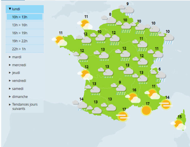
And Paris isn't the only place in France currently on alert for flooding, with flood warnings extended across the country on Monday morning.
 
READ ALSO:

France weather latest: Flood warnings extended as downpours continuePhoto: AFP

WEATHER

Norway to get a taste of summer with 20C days this week

Summer is finally here! Or least it is if you live in southern Norway, where a warm front coming up from Europe will bring t-shirt temperatures of 20C by Thursday, according to forecasts.

Norway to get a taste of summer with 20C days this week

Warm air from southern Europe will combine with a high pressure zone which will bring clear skies and sunshine, with summery weather coming towards the end of the week, Norway’s national weather forecaster Yr has reported. 

“Thursday and Friday especially will be nice,” Ingrid Villa, a meteorologist at the Norwegian Meteorological Institute, told the public broadcaster NRK. “Then we will probably get temperatures of over 20 degrees Celsius in some places.” 

Patches of 20C warmth are expected both in western Norway around Bergen and in Western Norway around Oslo, with the area around Tromsø expected to have slightly cooler weather, although Villa said that “it will absolutely be something like summer there too”. 

The warm sunny weather is, however, expected to pass northern Norway by, with grey overcast skies expected for much of this week. 

But if you think summer has come to Norway to stay, you risk disappointment as much cooler temperatures are expected next week.  

“There’s nothing unusual in getting an early taste of summer in April and the start of May, and then we can quickly go back to cooler more spring-like weather,” Villa said. 

SHOW COMMENTS