SHARE
COPY LINK

WEATHER

Storms and heavy rain bring trains to halt at Frankfurt central station

Rail transport in and out of Frankfurt was brought to a stop for half an hour on Tuesday, after storms made travel out of the central station too risky.

Storms and heavy rain bring trains to halt at Frankfurt central station
Storm clouds over Frankfurt on Tuesday. Photo: DPA

Torrential rain and gale force winds forced Deutsche Bahn to delay all travel out of the central station for a half hour period on Tuesday afternoon, starting at 2.45pm.

Flights out of Frankfurt Airport, the busiest air hub in Germany, were also delayed, and in some cases cancelled altogether.

Planes arriving at the airport were given the chance to land, but they were not brought into the gates by the land crew, so as not to endanger their lives.

Frankfurt fire services reported that they were called out roughly 180 times. Volunteer crews were also called into action to assist their professional colleagues. The main causes for call outs were trees that had been blown over by the wind and flooded buildings. No injuries were reported.

The German Weather Service (DWD) announced a severe weather warning for the Rhine-Main area for the day. It said that winds of up to 98 km/h had been recorded at Frankfurt Airport, and warned that storms would continue into the night.

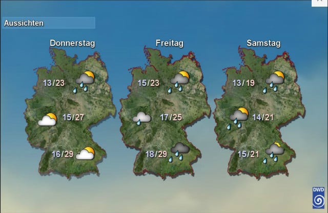
After days of warm weather, the whole of Germany is to face more unsettled conditions, as a cold front moves in from the east coast of Scotland. By Friday the DWD expects rain throughout much of the country.

WEATHER

Germany braces for more severe storms and heavy rain

Storms have been sweeping across Germany since Friday. Residents in the south-west were hit first, but other regions can expect thunderstorms and severe rain from Tuesday.

Germany braces for more severe storms and heavy rain

Parts of Bavaria, Rhineland-Palatinate, Hesse and Saarland should be prepared for thunderstorms and heavy rain.

“On Tuesday, another low-pressure zone will form over Germany, increasing the risk of severe weather,” said the German Weather Service (DWD).

Over the Whitsun weekend, a series of storms hit Germany. Residents in Saarland and south-west Rhineland-Palatinate in particular battled against flooding.

A deluge of rain caused landslides as well as flooded roads and cellars in these two regions. Rail services also came to a temporary standstill, but resumed on Saturday.

According to Saarland state premier Anke Rehlinger (SPD), emergency services were called out on 4,000 rescue operations. However, tragedy struck when a 67-year-old woman died after being hit by an emergency vehicle. Authorities said no one else was seriously injured.

READ ALSO: Floods easing in Germany’s Saarland but situation remains serious

From the Eifel via central Hesse to Bavaria

From Tuesday, stormy weather will affect other regions in Germany.

“This time, the focus will probably not be in Saarland and southern Rhineland-Palatinate, but a little further north, in the area from the Eifel region to central Hesse and south-east Bavaria,” said meteorologist Nico Bauer from the DWD.

German Chancellor Olaf Scholz (L) and Saarland State premier Anke Rehlinger (R) wades through water as they visit flood stricken town of Kleinblittersdorf.

German Chancellor Olaf Scholz (L) and Saarland State premier Anke Rehlinger (R) wades through water as they visit flood stricken town of Kleinblittersdorf. Photo: Iris Maria Maurer / AFP

From the early afternoon, thunderstorms, some of them heavy, are expected in a strip from south-east and eastern Bavaria via Hesse to northern Rhineland-Palatinate and North Rhine-Westphalia.

Heavy rainfall of up to 25 litres per square metre is forecast to hit these areas. Locally, up to 40 litres per square metre is possible. Hailstones and high winds are also expected. According to the DWD, heavy rain and thunderstorms are likely to move to the north-east of Germany during the night to Wednesday.

Isolated storms have also affected other regions in Germany. Four people are fighting for their lives and a further six are seriously injured following a lightning strike on the banks of the Elbe in Dresden on Monday evening. 

Damage ‘in the millions’ 

While the current crisis is not yet over, the areas affected by heavy flooding are already beginning to come to terms with the situation. According to initial estimates, the floods have caused damage “well into the millions”, Saarland’s state premier Rehlinger said. The exact extent will only be known once the water has receded completely.

“However, it is already clear today that we will have to deal with massive damage to private property, but also to infrastructure such as roads, bridges and day care centres,” she said. “We have been fighting against masses of water for a few days, but we will certainly have to deal with the consequences for years.”

According to DWD meteorologist Bauer, heavy rainfall like this is becoming more frequent in Germany due to climate change.

“They are becoming more frequent and more intense, simply because a warmer atmosphere can absorb more moisture and the rainfall is therefore heavier,” he said. 

READ ALSO: ‘Record heat deaths and floods’: How Germany is being hit by climate change

SHOW COMMENTS