SHARE
COPY LINK

STORM

Hurricane force storm brings flood threat to north Germany

On Wednesday the north of Germany is set to be hit by torrential rain and hurricane force winds, as the low pressure "Axel" moves in.

Hurricane force storm brings flood threat to north Germany
Walkers at the Baltic coast town of Graal-Müritz. Photo: DPA

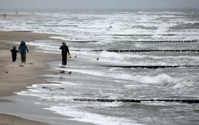
The first sign of troubles to come will be winds reaching up to 110 km/h blowing across the north of the country.

The weathermen are also warning of the possibility of flooding on the Baltic Sea coast on Wednesday evening.

The government’s maritime office (BSH) said that sea levels could rise to 1.50 metres above normal, or higher.

Ines Perlet from the BSH said that if water levels rise over 1.50 metres above normal, serious flooding would ensue due to the fact that sea levels in the Baltic are already 30cm to 40cm higher than average.

Also on the North Sea, coastal tides are set to be unusually high. At the mouth of the River Elbe, tides will be 1.50 metres higher than normal on Wednesday morning.
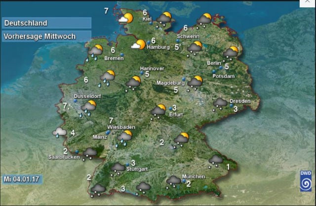
Source: DWD

“Some people might ask themselves why moderate winds could bring about such high water levels,” said Jürgen Holfort from the BSH, explaining that even a mild storm could cause flooding in the current conditions.

The last time there was extensive flooding on the Baltic Sea coast was on November 1st 2006. Before that there was severe flooding in the winter of 2002.

The low pressure coming in from the north is also set to bring heavy snowfall to Germany’s mountainous regions. The Ore Mountains in eastern central Germany could be covered by 30cm of fresh powder on Wednesday.

The German Weather Service (DWD) is also predicting further snowfall across the east and south of the country on Wednesday, with Dresden, Munich and Stuttgart all set to be blanketed in more of the white stuff.

Member comments

Log in here to leave a comment.
Become a Member to leave a comment.

WEATHER

‘Turbo spring’: Germany to see temperatures above 25C

Germany is set for a blast of warm weather in the coming week as the colder spell eases off.

'Turbo spring': Germany to see temperatures above 25C

“The late winter weather of the past few days with frost and snow is a thing of the past for the time being, and spring will kick into turbo gear over the next few days,” said meteorologist Adrian Leyser from the German Weather Service (DWD) on Friday.

Temperatures are expected to rise sharply over the weekend with plenty of sunshine, forecasters said. In Germany anything above 25C is classed as a summer day. “The summer mark of 25C will be cracked regionally as early as Sunday,” said Leyser.

It comes as snow and hail hit Germany last week, and temperatures fell below freezing in some places.

But showers and thunderstorms are still possible in the west and north of Germany. Maximum temperatures there are expected to reach around 20C. 

According to the DWD, spring will get a little damper on Monday, with a few rain spells.  “However, the next low pressure system over Western Europe is preparing to turn on the warm air jet again from Tuesday,” said the meteorologist.

On Wednesday – which is a public holiday across Germany for International Workers’ Day – temperatures could soar nearer 30C. 

“In the south and east, we are even approaching the 30C mark,” said Leyser. However, the weather will remain “susceptible to disruption”, said Leyser, especially in the west where there is a risk of isolated and sometimes severe thunderstorms.

READ ALSO: What to do on May 1st in Germany

SHOW COMMENTS