P { margin-bottom: 0.21cm; }
P { margin-bottom: 0.21cm; } P { margin-bottom: 0.21cm; }A:link { }
Almost all flights meant to leave and arrive at Hamburg airport did not, schools closed and ships stayed in harbour ahead of the bad weather with wind speeds of 140 km/h expected. Companies across the hit areas have sent staff home, Welt newspaper reported.
By the afternoon, winds of 140 km/h were howling down the coast, where children largely did not go to school. Schools as far south as Berlin – three hours inland – were sending pupils home early.
The entire train network in Schleswig-Holstein had been shut down, as was motorways A7. Some towns on exposed bits of coast, like Borkum, have advised residents to seek higher ground, Welt newspaper reported.
CLICK HERE for photos of the storm

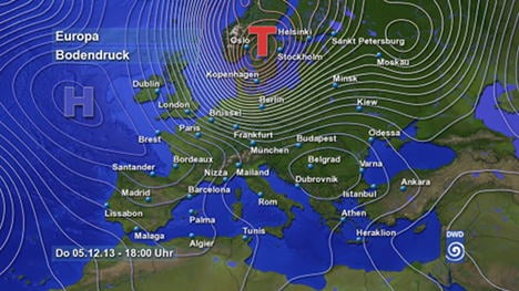
The DWD issued an extreme weather warning for the states of Hamburg, Schleswig-Holstein, Lower Saxony and Bremen. Travelling from Greenland – Xaver has already hit Scotland, leaving large areas without electricity and killed one person.
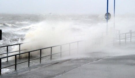
Storm “Xaver” will be longer and more intense than “Christian” which hit in October and in Hamburg, coastal workers are preparing for a six metre surge in water levels – this would go straight over storm barriers.
Fire brigades have been going between houses since 7am advising people to secure their windows and doors. Cars should also be parked somewhere safe and any furniture on balconies and terraces stacked away.
Anyone in the area should try to stay at home and avoid narrow streets and forests.
Schools as well as Christmas markets in both Kiel and Hamburg are shut, as are visitor attractions and cathedrals. As of 10am, Chemnitz in Saxony – miles from the most intense weather, said it would also close theirs, just to be safe.
Leipzig Christmas market was also shut on Thursday afternoon.
Esther Carretero, 45, who lives in the centre of Hamburg with her three children and husband, said people had been leaving work early and were following advice to stay indoors.
"It is really dark and very windy," she told The Local on Thursday afternoon. "There were not many people around today."
Ferries leaving from Kiel harbour going to Denmark and Scandinavia are, for the time being, staying in port because of very high tides and huge waves.
The storm is expected to hit at high tide leading to fears of a repeat of the floods which devastated Hamburg in 1962. Police removed eight surfers who were riding waves on the Alster river. They face fines.
Temperatures are, the DWD said, expected to plummet overnight and northern Germany will freeze – meaning potentially treacherous icy conditions on Friday morning.
The south of the country will also experience gale-force blasts, especially in the mountains, although this will not be as bad as in the north, which will have to wait until Friday for the wild weather to calm down.

Member comments