SHARE
COPY LINK

WEATHER

Snow marks winter’s return to Switzerland

Snow hit low-lying areas of Switzerland for the first time this season on Thursday with accumulations of up to five centimetres in the western part of the country and up to 20 centimetres in the mountains.

Snow marks winter's return to Switzerland
Gstaad-Saanenland on Thursday morning: the snowfall is not yet sufficient to open most ski resorts. Photo: Switzerland Tourism (Webcam)

The wintry conditions led to tailbacks on the A1 and A9 motorways and main roads around Lausanne, according to media reports.

The right lane of the A-1 was blocked for an hour between Winterthur and upper Matzingen in the direction of Saint Gallen on Thursday morning because of an accident in icy conditions, the Blick newspaper reported online.

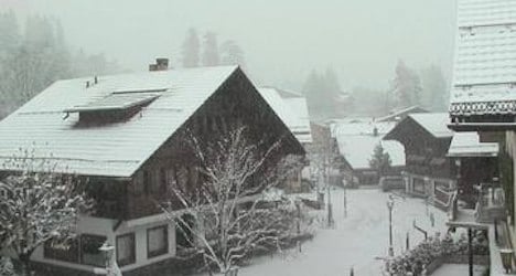
Zurich is bracing for snow on Friday when more of the white stuff is forecast across the country, except for the valleys of Ticino, MeteoSwiss, the national weather service said.

Up to 15 centimetres is expected in areas of the canton of Zurich at an altitude between 600 and 800 metres.

Actual accumulations will depend on temperatures, which are hovering either side of zero in the valleys and on the plateau.

There is still not enough snow for most of the country’s ski resorts to open, although Switzerland Tourism said seven ski areas were open with limited lift services on Thursday.

At Zermatt, in the canton of Valais, 16 of the area’s 54 lifts were reported operating.

Other resorts with limited operations included Gstaad Mountain Rides (Glacier 3000) in the Bernese Oberland, Engelberg-Titlis and Rigi in Lucerne, and the Graubünden ski centres of Davos, Klosters and Engadin-St. Moritz.

Most ski resorts are not scheduled to start lifts running until the end of the month or in December.

However, Verbier in the canton of Valais announced it will open this weekend with a limited number of runs open, while Crans-Montana, also in Valais, is scheduled to start its season on Saturday.
 

Member comments

Log in here to leave a comment.
Become a Member to leave a comment.

WEATHER

IN PICTURES: ‘Exceptional’ Sahara dust cloud hits Europe

An "exceptional" dust cloud from the Sahara is choking parts of Europe, the continent's climate monitor said on Monday, causing poor air quality and coating windows and cars in grime.

IN PICTURES: 'Exceptional' Sahara dust cloud hits Europe

Copernicus Atmosphere Monitoring Service said the latest plume, the third of its kind in recent weeks, was bringing hazy conditions to southern Europe and would sweep northward as far as Scandinavia.

Mark Parrington, senior scientist at Copernicus, said the latest event was related to a weather pattern that has brought warmer weather to parts of Europe in recent days.

“While it is not unusual for Saharan dust plumes to reach Europe, there has been an increase in the intensity and frequency of such episodes in recent years, which could be potentially attributed to changes in atmospheric circulation patterns,” he said.

This latest episode has caused air quality to deteriorate in several countries, Copernicus said.

The European Union’s safe threshold for concentrations of PM10 — coarser particles like sand and dust that that can irritate the nose and throat — has already been exceeded in some locations.

A picture taken on April 8, 2024 shows a rapeseed field under thick sand dust blown in from the Sahara, giving the sky a yellowish appearance near Daillens, western Switzerland. – An “exceptional” dust cloud from the Sahara is choking parts of Europe, the continent’s climate monitor said, causing poor air quality and coating windows and cars in grime. (Photo by Fabrice COFFRINI / AFP)

The worst affected was the Iberian Peninsula in Spain but lesser air pollution spikes were also recorded in parts of Switzerland, France and Germany.

READ ALSO:

Local authorities in southeastern and southern France announced that the air pollution threshold was breached on Saturday.

They advised residents to avoid intense physical activity, particularly those with heart or respiratory problems.

The dust outbreak was expected to reach Sweden, Finland and northwest Russia before ending on Tuesday with a shift in weather patterns, Copernicus said.

The Sahara emits between 60 and 200 million tonnes of fine dust every year, which can travel thousands of kilometres (miles), carried by winds and certain meteorological conditions.

The Spanish Canary Islands off the coast of northwest Africa saw just 12 days within a 90-day period from December to February where skies were free of Saharan dust, the local weather agency Aemet had reported.

SHOW COMMENTS