SHARE
COPY LINK

WEATHER

Cold front ‘Xevera’ bringing taste of winter

The final week of October will draw to a close with a taste of the coming Central European winter, as the cold front 'Xevera' brings a blast of cold air and possible snow to Germany.

Cold front 'Xevera' bringing taste of winter
Photo: DPA

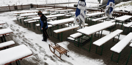
Mid and higher elevations should expect below-zero temperatures and may even see the first dusting this year, German Weather Service meteorologist Dorothea Paetzold said. Lower elevations won’t be spared either, with mercury levels set to plunge dramatically.

The winter chill will hit most of the country starting on Monday night, as rain continues across much of the south and east. In the northwest, where night skies will remain clear, there could be the first frost of the year.

Temperatures on Tuesday will reach between six and ten degree Celsius at lower elevations, but mountainous regions in the middle of the country and in the Alps will likely see precipitation turn to snow.

As the week progresses overnight lows will creep below the freezing mark, making for widespread wintery driving conditions.

Click here for The Local’s weather forecast.

WEATHER

Germany braces for more severe storms and heavy rain

Storms have been sweeping across Germany since Friday. Residents in the south-west were hit first, but other regions can expect thunderstorms and severe rain from Tuesday.

Germany braces for more severe storms and heavy rain

Parts of Bavaria, Rhineland-Palatinate, Hesse and Saarland should be prepared for thunderstorms and heavy rain.

“On Tuesday, another low-pressure zone will form over Germany, increasing the risk of severe weather,” said the German Weather Service (DWD).

Over the Whitsun weekend, a series of storms hit Germany. Residents in Saarland and south-west Rhineland-Palatinate in particular battled against flooding.

A deluge of rain caused landslides as well as flooded roads and cellars in these two regions. Rail services also came to a temporary standstill, but resumed on Saturday.

According to Saarland state premier Anke Rehlinger (SPD), emergency services were called out on 4,000 rescue operations. However, tragedy struck when a 67-year-old woman died after being hit by an emergency vehicle. Authorities said no one else was seriously injured.

READ ALSO: Floods easing in Germany’s Saarland but situation remains serious

From the Eifel via central Hesse to Bavaria

From Tuesday, stormy weather will affect other regions in Germany.

“This time, the focus will probably not be in Saarland and southern Rhineland-Palatinate, but a little further north, in the area from the Eifel region to central Hesse and south-east Bavaria,” said meteorologist Nico Bauer from the DWD.

German Chancellor Olaf Scholz (L) and Saarland State premier Anke Rehlinger (R) wades through water as they visit flood stricken town of Kleinblittersdorf.

German Chancellor Olaf Scholz (L) and Saarland State premier Anke Rehlinger (R) wades through water as they visit flood stricken town of Kleinblittersdorf. Photo: Iris Maria Maurer / AFP

From the early afternoon, thunderstorms, some of them heavy, are expected in a strip from south-east and eastern Bavaria via Hesse to northern Rhineland-Palatinate and North Rhine-Westphalia.

Heavy rainfall of up to 25 litres per square metre is forecast to hit these areas. Locally, up to 40 litres per square metre is possible. Hailstones and high winds are also expected. According to the DWD, heavy rain and thunderstorms are likely to move to the north-east of Germany during the night to Wednesday.

Isolated storms have also affected other regions in Germany. Four people are fighting for their lives and a further six are seriously injured following a lightning strike on the banks of the Elbe in Dresden on Monday evening. 

Damage ‘in the millions’ 

While the current crisis is not yet over, the areas affected by heavy flooding are already beginning to come to terms with the situation. According to initial estimates, the floods have caused damage “well into the millions”, Saarland’s state premier Rehlinger said. The exact extent will only be known once the water has receded completely.

“However, it is already clear today that we will have to deal with massive damage to private property, but also to infrastructure such as roads, bridges and day care centres,” she said. “We have been fighting against masses of water for a few days, but we will certainly have to deal with the consequences for years.”

According to DWD meteorologist Bauer, heavy rainfall like this is becoming more frequent in Germany due to climate change.

“They are becoming more frequent and more intense, simply because a warmer atmosphere can absorb more moisture and the rainfall is therefore heavier,” he said. 

READ ALSO: ‘Record heat deaths and floods’: How Germany is being hit by climate change

SHOW COMMENTS