
Swiss federal weather service MeteoSchweiz reported that sunny conditions are expected across most of Switzerland on Thursday and Friday.
However, violent storms and even hail showers are forecast to return on Saturday afternoon, with more developing throughout Sunday.
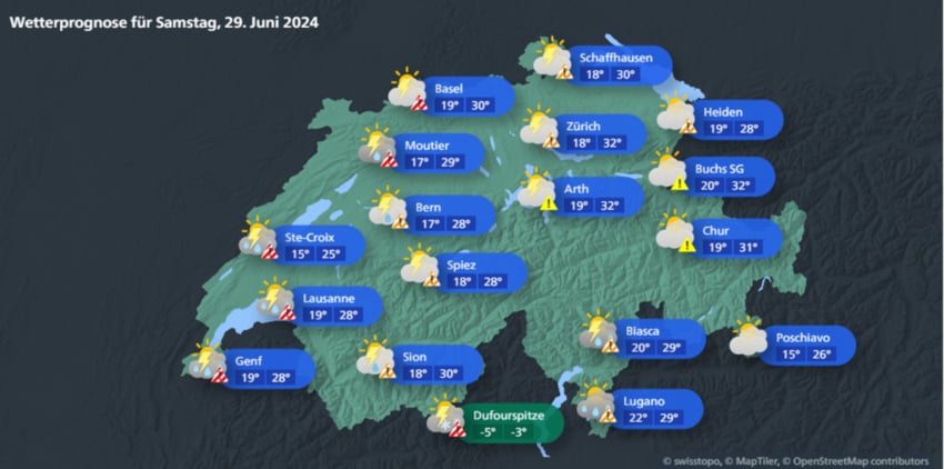
Dangerous storm conditions are most likely in the cantons of Geneva, Vaud, Neuchâtel, Jura, Basel-City, Basel-Land and north-west parts of Bern, according to the meteorological service.
The storms pose a moderate threat in the remainder of Bern, Ticino, Lucerne, Aargau, Appenzell Outer Rhodes and Appenzell Inner Rhodes.
Alpine areas are the most likely to be affected by rain, thunder and lightning, while the lowlands will experience milder and drier conditions.
MeteoSchweiz reports that weather conditions will then improve across the next week.
Severe weather disruptions
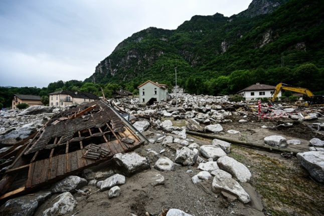
The forecast comes after parts of Switzerland were subjected to severe thunderstorms and rain over the past seven days.
On Saturday, June 22, storms in the canton of Graubünden left police searching for three missing hikers in the Mesolcina Valley and forced dozens of residents to be evacuated amid fears of flooding and landslides.
Also in Graubünden, the A13, an important motorway connecting Switzerland’s north and south, was also severed by landslides and flooding near the town of Lostallo.
The motorway will completely closed until July 10, when one lane will be reopened. It is not expected that all lanes will be operational before the end of the year.
In the canton of Valais, the storms also temporarily isolated Zermatt from the rest of the country, as roads were blocked and the Matterhorn-Gotthard-Bahn railway was damaged, necessitating several weeks of repair.
Similar weather on Tuesday night also led to what has been called ‘the flood of the century’ in the canton of Vaud, where a month’s worth of torrential rain left the town of Morges, on the shores of Lake Geneva under several feet of water.
Better preparation required
The dangerous conditions have led to calls for the country to better prepare for such natural disasters.
Swiss hydrologist Frédéric Jordan told Swiss public radio, RTS, on Monday: “In the last hundred years or so, heavy floods have typically occurred between August and October.
“However, if we look at the last 12 months, we had a major flood on the Rhône River on November 14, 2023 and one on June 21, 2024, which is quite new,” he explained.
He went on to state that “Switzerland must take note of this new information and adapt.”
Despite fluctuations in weather trends over the past four decades, flooding has cost Switzerland approximately 3.5 billion francs since records began in 1972.
In that period of time, the worst flooding occurred in August 2005, leaving much of the country underwater and resulting in multiple deaths and the evacuation of thousands.
Outlook for the rest of the summer
Meteorologist Roger Perret, of the Swiss weather blog MeteoNews, nevertheless offers hope for those looking for a sunny summer.
Analysing air pressure, precipitation and ocean temperature data, his ‘Summer Oracle’ predicts warmer, drier weather over July and August.
He writes: “The record high temperatures of the seas certainly indicate that there will be heat waves, which encourage the formation of Atlantic lows, which will encourage hot south to southwest conditions over central and western Europe.
Perret notes in his blog that his MeteoNews colleague, Fred Decker, offers a similar prognostication
“July and August would then be largely dominated by the Azores high, which would mean that Switzerland would often have dry, sunny and above-average warm weather.
“Longer periods of heat are also quite possible. Thunderstorms would occur mainly in the and would be rare in the lowlands.”
Member comments