SHARE
COPY LINK

SKIING

LATEST: Five cross-country skiers found dead in Swiss Alps

Five of the six cross-country skiers who went missing in the Swiss Alps over the weekend have been found dead.

LATEST: Five cross-country skiers found dead in Swiss Alps
The hikers were found dead on the Zermatt-Arolla route. Photo: Pixabay

Poor weather conditions complicated the search in the mountains, but a team of rescuers was finally able to be dispatched to the area by helicopter, where they “discovered the bodies of five of the six people reported missing”, Valais cantonal police announced on Monday.

After the group, which left Zermatt on Saturday morning toward the resort of Arolla, had not arrived at their destination at 4 pm, a family member had alerted the police.

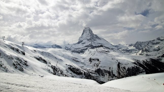
The search was launched on the Zermatt-Arolla hiking route, focusing especially on the  Col de Tête Blanche sector located at the altitude of approximately 3,500 metres.

“All day Sunday, the various specialised units of the Cantonal Police, in particular the mountain group as well as the technical and telecommunications officers, were engaged alongside the rescuers and the army air forces,” the police said.

The weather conditions were “catastrophic”, with freezing temperatures and a significant avalanche risk, Christian Varone, head of Valais cantonal police told reporters.

A person who had gone to pick up the group in Arolla sounded the alarm shortly after 4 pm  on Saturday.

An hour later, a member of the missing group managed to reach the rescue services by mobile phone, allowing them to pinpoint where to search for the skiers.

Varone said rescue workers had pulled out all the stops to try to reach them, but that the dire weather conditions had long prevented helicopters and teams of expert skiers and mountaineers from reaching the area.

“We were trying the impossible,” he said, adding that the mission had pushed its efforts “to the extreme, extreme limit”, but were forced to turnaround to avoid “seriously endangering the lives of the rescue workers”.

“Sometimes you have to bow before nature.”

On Sunday, a team consisting of two rescue workers, a doctor and a mountain police officer, was finally able to be dropped off by helicopter nearby, police said.

“At around 9:20 pm, it reached the Tête Blanche sector, where it discovered the bodies of five of the six people who were missing,” it said in a statement.

The search is meanwhile continuing for the last member of the group.

“As long as there is hope we will keep going… while remaining realistic in view of the conditions this person has been in for the past 48 hours,” Varone said.

Police have yet to reveal the identities of those involved, only saying that the five family members were from Wallis canton and the sixth person from the canton of Fribourg.

Valais lead prosecutor Beatrice Pilloud told reporters that an investigation had been launched to determine the circumstances surrounding the incident.

Member comments

Log in here to leave a comment.
Become a Member to leave a comment.
For members

HIKING

The seven best hikes around Geneva

There are some great one day hikes within easy reach of the Swiss city of Geneva but some are easier than others, writes Monty Pierce Jones.

The seven best hikes around Geneva

When you walk across the Pont du Mont Blanc in the centre of Geneva you notice that you can’t actually see Mont Blanc itself. 

Instead, what catches your eye are a series of smaller, but no less iconic, mountains: Le Salève, Les Voirons, and Le Môle which make up the backdrop of Rive Gauche, and when looking the other way it is impossible to miss the Jura, with Crêt de la Neige and La Dôle being the more eye-catching summits of “Switzerland’s spine”.

These foothills hug the Geneva metropolitan area (forming la cuvette genevoise) – and other than trapping pollution, they offer some brilliant hiking for locals and visitors alike. 

Here are 7 of the best.

Le Salève

The Salève, is known as the balcony of Geneva. The main backdrop of this Swiss city is found in… France, like almost every other hike on this list. It feels like a great limestone wave about to crash onto you: the “French side” builds up slowly to the abrupt cliffs, striations, and quarry of the “Genevois side”. Frankenstein’s monster scales this perpendicular face in Mary Shelley’s book.

I’m not suggesting you follow in Frankenstein’s footsteps exactly, but you too can climb the Salève. Here are two recommended routes:

Via Le Pas de l’Échelle

This four and half hour, 4.4km hike offers an easier walk – but it’s not to be underestimated. Le Pas de l’Échelle is the historic way up the hill, its carved stone step sections attest to its 14th century roots. Park at the Gare de Départ of the Téléphérique (15 minute drive from Geneva’s centre, 40 minutes with a walk if you take the 8 bus) and head towards Chemin du Bois Meriguet. After an hour or so you’ll pass through the lovely village of Monnetier nestled between the Petit and Grand Salève – before reaching the “Panorama”, where you might catch a few paragliders taking off.

Via Chemin de la Grande Gorge

This is a more difficult hike – both longer and steeper than Le Pas de l’Échelle. As the name suggests, it follows the “big gorge” that cuts through this part of the Salève. It winds its way through the couloir before cutting left towards the “Panorama”. It is a more adventurous, secluded climb, and was apparently used by smugglers back in the day. Start from the same spots as Le Pas de l’Échelle.

You can go up one way and down the other to mix things up.

Get more info on trekking La Salève.

Le Signal des Voirons

Le Massif des Voirons (1,480 m) reaches higher than the more dramatic Salève (1,379 m) despite often being overshadowed by it.

This is an injustice, as getting to the top earns you the best 360 degree view on this list. Les Dents du Midi are viewable from the top. It is also wilder than Le Salève, so keep an eye out for orchids, chamois, and if you’re really lucky, a lynx.

Start from the Lac de Machilly parking (30 minutes by car) or the Machilly station (45 minutes by train via Annemasse) and head towards Chemin du Sauget. Turn right on Route du Seujet and you’ll find yourself at the signposted start of the five hour – 17 km loop of Les Voirons.

Le Môle

Le Môle sits further back from the city, but at 1,863 metres (the tallest mountain on this list) it is no molehill. In fact, it has one of the most recognisable silhouettes in the region: a near-perfect pyramid. It too was mentioned by Shelley in Frankenstein.

For an easy, sunny four hour – 9 km hike, drive 40 minutes to Saint-Jean-de-Tholome, park at Chez Beroud, and head towards the summit.

Petit Salève Loop

Park at the Château d’Etrembières (20 minute drive from the centre – can also take the 17 tram and walk). Head towards the forest and walk for around 2 hours hours. You will eventually reach the Camp des Allobroges near the summit. The Allobroges were the Celtic tribe that founded Geneva, they may even have helped Hannibal cross the Alps.

The remnants of their hillfort (or oppidum) – placed there as a symbol of control – are probably the best thing about the hike. The 6km loop should take you about four hours. On the way up you’ll have great views of Geneva and the Jura, and on the way back of Mont Blanc and the Môle.

Chemin de La Dôle

This hike is the only one on this list that is wholly in Switzerland, funnily enough. La Dôle is known for the iconic weather dome that you can easily spot from Le Jardin Anglais.

The views from the summits of the other hikes on this list, as wonderful as they are, do cross-over a fair amount: you can spot Le Môle from Les Voirons and vice versa; they all have great views of Geneva and the Massif du Mont Blanc.

La Dôle offers something different, you get a better sense of l’arc lémanique, and more expansive views of the alps (especially the Bernese and Chablais Alps). It is the furthest out from Geneva, at an hour by train or 45 minutes by car, but it’s worth it.

Le Chemin de La Dôle (SuisseMobile route 116) is a long but easy hike. You will likely walk 15km in 5 hours. You should start in La Givrine and end in St Cergue, though you can keep going to Nyon and in doing so complete the last stage of the Jura Crest Trail (SuisseMobile route 5).

Le Reculet + Crêt de la Neige

This is the hardest hike on this list, if you’re up to it you’ll reach the highest point in the Jura mountains. Le Reculet and Crêt de la Neige don’t jut out much from the Jura range but you can spot them from around the city. Next time you find yourself on one of the stops of the 12 tram in Rive Gauche, look up and you’ll realise that they are often framed by Geneva’s low-rise buildings.

It will take you 40 minutes by car to get to the trailhead (Tiocan, Thoiry), or 1h40 minutes by public transport (50 minutes to Thoiry – take the 18 tram and the 68 bus – and 50 minutes walk). Be prepared for a 13.5 km, 7 hour hike – and a view that encompasses every other peak on this list. It’s worth it.

Further reading:

The websites Monts de Geneve offers more info for treks in the area.

SHOW COMMENTS