SHARE
COPY LINK

SKIING

Skiing in Switzerland: The best way to check if there’s snow on the slopes

February is traditionally a month when people in Switzerland (and abroad) head to the Alpine slopes. But this year, the mild weather and lack of snow are a problem in some areas. Here's how you can find out the conditions.

A snowcat parked on remaining snow at Adelboden Swiss alpine resort, on January 6th, 2023. Due to the lack of snow, several mid-altitude ski resorts had to close in Switzerland, and some resorts are struggling this year.
A snowcat parked on remaining snow at Adelboden Swiss alpine resort, on January 6th, 2023. Due to the lack of snow, several mid-altitude ski resorts had to close in Switzerland, and some resorts are struggling this year. (Photo by Fabrice COFFRINI / AFP)

If you’re heading to a Swiss ski resort, you’ll likely be wondering: what’s the condition of the slopes?

And it’s a good question. Due to the mild start to 2024, some ski resorts are struggling because there hasn’t been enough snowfall this. year. 

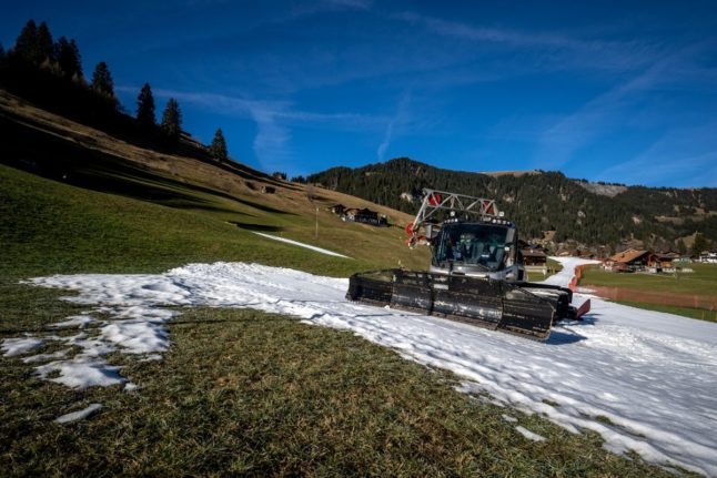
For instance, the Dent-de-Vaulion ski area among the Jura mountains in the canton of Vaud is usually a popular destination for winter sports fans, but is drawing in less visitors this year. 

That’s because the ski slopes have almost no snow on the ground.

“Green space instead of a snowy idyll: climate change is making Swiss ski areas sweat,” the Swiss news outlet Blick said on Monday. 

It’s not the first time a lack of snow has hit sites. Last year, mild conditions resulted in several Swiss ski resorts closing.

Experts say the climate crisis spells bad news for the long-term outlook on the skiing industry in Europe.

According to Swiss weather site MeteoNews, this January was too warm overall, despite several days of icy conditions. It still remains mild – temperatures up to 11 or even 12C are possible in the canton of Vaud in the coming days, and there’s no snow forecast.

Some ski resorts are bringing in artificial snow to try and get round the problem. These include Wildhaus in the canton of St. Gallen. 

Meanwhile, the Adelboden ski area in the Bernese Oberland is also struggling with too little snow. 

READ ALSO: What you should know about skiing in the Swiss Alps this winter

How can you find out if there is snow on the slopes?

So that winter sports enthusiasts can be sure whether there is enough snow to enjoy their trip, Switzerland Tourism has launched the ‘snowticker’ platform in collaboration with the resorts. It is aimed at solving the problem of unknown piste conditions.

On the website, a map brings together webcams from all over Switzerland – from the 4 Vallées in Valais to Alt St. Johann, St Gallen, in eastern Switzerland. With a total of 814 cameras, images from the ski areas can be seen in real time. 

There are often several webcams per winter destination. In Davos, for instance, you can check the piste conditions from 13 different stations.

Of course, even with a ‘snowticker’ it is difficult to estimate exactly what the slope conditions feel like. Even top skiing professionals can rarely judge just by looking to figure out how wet or grippy the snow is. Nevertheless, the webcams provide an insight into the amount of snow in the area. 

Member comments

Log in here to leave a comment.
Become a Member to leave a comment.
For members

HIKING

The seven best hikes around Geneva

There are some great one day hikes within easy reach of the Swiss city of Geneva but some are easier than others, writes Monty Pierce Jones.

The seven best hikes around Geneva

When you walk across the Pont du Mont Blanc in the centre of Geneva you notice that you can’t actually see Mont Blanc itself. 

Instead, what catches your eye are a series of smaller, but no less iconic, mountains: Le Salève, Les Voirons, and Le Môle which make up the backdrop of Rive Gauche, and when looking the other way it is impossible to miss the Jura, with Crêt de la Neige and La Dôle being the more eye-catching summits of “Switzerland’s spine”.

These foothills hug the Geneva metropolitan area (forming la cuvette genevoise) – and other than trapping pollution, they offer some brilliant hiking for locals and visitors alike. 

Here are 7 of the best.

Le Salève

The Salève, is known as the balcony of Geneva. The main backdrop of this Swiss city is found in… France, like almost every other hike on this list. It feels like a great limestone wave about to crash onto you: the “French side” builds up slowly to the abrupt cliffs, striations, and quarry of the “Genevois side”. Frankenstein’s monster scales this perpendicular face in Mary Shelley’s book.

I’m not suggesting you follow in Frankenstein’s footsteps exactly, but you too can climb the Salève. Here are two recommended routes:

Via Le Pas de l’Échelle

This four and half hour, 4.4km hike offers an easier walk – but it’s not to be underestimated. Le Pas de l’Échelle is the historic way up the hill, its carved stone step sections attest to its 14th century roots. Park at the Gare de Départ of the Téléphérique (15 minute drive from Geneva’s centre, 40 minutes with a walk if you take the 8 bus) and head towards Chemin du Bois Meriguet. After an hour or so you’ll pass through the lovely village of Monnetier nestled between the Petit and Grand Salève – before reaching the “Panorama”, where you might catch a few paragliders taking off.

Via Chemin de la Grande Gorge

This is a more difficult hike – both longer and steeper than Le Pas de l’Échelle. As the name suggests, it follows the “big gorge” that cuts through this part of the Salève. It winds its way through the couloir before cutting left towards the “Panorama”. It is a more adventurous, secluded climb, and was apparently used by smugglers back in the day. Start from the same spots as Le Pas de l’Échelle.

You can go up one way and down the other to mix things up.

Get more info on trekking La Salève.

Le Signal des Voirons

Le Massif des Voirons (1,480 m) reaches higher than the more dramatic Salève (1,379 m) despite often being overshadowed by it.

This is an injustice, as getting to the top earns you the best 360 degree view on this list. Les Dents du Midi are viewable from the top. It is also wilder than Le Salève, so keep an eye out for orchids, chamois, and if you’re really lucky, a lynx.

Start from the Lac de Machilly parking (30 minutes by car) or the Machilly station (45 minutes by train via Annemasse) and head towards Chemin du Sauget. Turn right on Route du Seujet and you’ll find yourself at the signposted start of the five hour – 17 km loop of Les Voirons.

Le Môle

Le Môle sits further back from the city, but at 1,863 metres (the tallest mountain on this list) it is no molehill. In fact, it has one of the most recognisable silhouettes in the region: a near-perfect pyramid. It too was mentioned by Shelley in Frankenstein.

For an easy, sunny four hour – 9 km hike, drive 40 minutes to Saint-Jean-de-Tholome, park at Chez Beroud, and head towards the summit.

Petit Salève Loop

Park at the Château d’Etrembières (20 minute drive from the centre – can also take the 17 tram and walk). Head towards the forest and walk for around 2 hours hours. You will eventually reach the Camp des Allobroges near the summit. The Allobroges were the Celtic tribe that founded Geneva, they may even have helped Hannibal cross the Alps.

The remnants of their hillfort (or oppidum) – placed there as a symbol of control – are probably the best thing about the hike. The 6km loop should take you about four hours. On the way up you’ll have great views of Geneva and the Jura, and on the way back of Mont Blanc and the Môle.

Chemin de La Dôle

This hike is the only one on this list that is wholly in Switzerland, funnily enough. La Dôle is known for the iconic weather dome that you can easily spot from Le Jardin Anglais.

The views from the summits of the other hikes on this list, as wonderful as they are, do cross-over a fair amount: you can spot Le Môle from Les Voirons and vice versa; they all have great views of Geneva and the Massif du Mont Blanc.

La Dôle offers something different, you get a better sense of l’arc lémanique, and more expansive views of the alps (especially the Bernese and Chablais Alps). It is the furthest out from Geneva, at an hour by train or 45 minutes by car, but it’s worth it.

Le Chemin de La Dôle (SuisseMobile route 116) is a long but easy hike. You will likely walk 15km in 5 hours. You should start in La Givrine and end in St Cergue, though you can keep going to Nyon and in doing so complete the last stage of the Jura Crest Trail (SuisseMobile route 5).

Le Reculet + Crêt de la Neige

This is the hardest hike on this list, if you’re up to it you’ll reach the highest point in the Jura mountains. Le Reculet and Crêt de la Neige don’t jut out much from the Jura range but you can spot them from around the city. Next time you find yourself on one of the stops of the 12 tram in Rive Gauche, look up and you’ll realise that they are often framed by Geneva’s low-rise buildings.

It will take you 40 minutes by car to get to the trailhead (Tiocan, Thoiry), or 1h40 minutes by public transport (50 minutes to Thoiry – take the 18 tram and the 68 bus – and 50 minutes walk). Be prepared for a 13.5 km, 7 hour hike – and a view that encompasses every other peak on this list. It’s worth it.

Further reading:

The websites Monts de Geneve offers more info for treks in the area.

SHOW COMMENTS