SHARE
COPY LINK

WEATHER

France braces for icy snap as flood alerts remain in north of country

Five departments in the north of France were still on heightened flood alert on Thursday, as forecasts predict a marked dip in temperatures across the country from the weekend.

France braces for icy snap as flood alerts remain in north of country
Firefighters evacuate inhabitants in Arques, northern France, after the river Aa flooded. (Photo by Denis Charlet / AFP)

Pas-de-Calais, in northern France, remained on the highest alert level for flooding on Thursday, while the body of a man in his seventies was recovered from a partially submerged car in the Loire-Atlantique département.

Flood waters had started to recede along the River Aa, officials said, though the département remained on the highest ‘red’ alert level on Thursday morning.

A further four northern départements – Ardennes, Aisne, Meuse and Nord – were kept under orange weather warnings, the second-highest, in forecaster Météo-France’s early bulletin. 

All five departments were set to remain on the same heightened alert levels into Friday at least, Météo-France indicated.

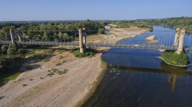
In Pas-de-Calais, 1,299 homes in 189 communes were affected by flooding along the rivers Aa, Liane, Hem, Canche, Lys-Plaine, Lys-Plaine, Lys-Amont and Lawe-Clarence, according to the Pas-de-Calais prefecture on Wednesday evening, as flood waters reached their peak along the Aa.

READ ALSO How to ensure your French property is insured for storm damage

A total of 450 firefighters from the Pas-de-Calais department were mobilised overnight, along with 120 additional firefighters and members of regional civil security training units from other areas. Rescuers carried out 115 evacuations in the area on Wednesday, bringing the total to 371 since Sunday.

Elsewhere, a 73-year-old man was found dead in his partially submerged car near Nantes, after apparently driving on a road closed to traffic due to flooding in the area. The victim’s partner had raised the alarm 24 hours earlier, after he had gone out for bread in the town of Saffré.

This is the third time parts of Pas-de-Calais have flooded since November. Between October 17th and December 31st, 464mm of precipitation was recorded in Pas-de-Calais. Over the same period in 2022, 296mm of rain fell.

There is no immediate let-up in the weather for those affected by the floods. Further rain and strong winds are forecast for northern and northwestern France on Thursday.

But a change from the mild, rainy conditions over Christmas and New Year is forecast from the weekend, as a colder, mostly drier air pushes into the country.

A dip in temperatures is expected from Friday morning. By Sunday, the mercury is set to rise no higher than between 0C and 2C at dawn across most of the country.

Morning frosts will become widespread from Sunday, January 7th, with temperatures dropping as low as -5C in the Massif Central and to the east of the country for much of the week. 

As children return to school after the Christmas holidays, morning temperatures in Paris, Amiens, Strasbourg and Aurillac are expected to remain noticeably below zero, while a chill wind is set to make it feel even colder.

Snow is expected in mountain regions at the weekend and, at higher altitudes, temperatures could fall as low as -10C, forecasters warned.

Member comments

Log in here to leave a comment.
Become a Member to leave a comment.
For members

ENVIRONMENT

How likely are droughts and water restrictions in France in summer 2024?

Much of France has faced severe flooding this winter, but other areas already face water restrictions, and there's an extra variable in store global weather patterns play their part

How likely are droughts and water restrictions in France in summer 2024?

France’s Bureau de Recherches Géologiques et Minières (BRGM) most recent report, in early March, revealed that the water table in France was ‘satisfactory over a large part of the country’, with levels above normal for the time of year in 46 percent of the country’s underground aquifers.

It warned at the time, however, that levels were low to very low in parts of Alsace, as well as in the Saône corridor and areas of Languedoc, from the south of the Massif Central to the coast, and the Roussillon area of southwest France.

March, too, was a wet month across the bulk of France – it was the fifth wettest since records began in 1958, according to national forecaster Météo-France.

Crucially however, most of the rain falling on the ground in France now will be gobbled up by vegetation, which means that very little water will make it through to aquifers. The groundwater recharge period, when underground water tables are refilled, is now over until late autumn 2024.

Basically, the water table is about as high as it’s going to get this summer.

Which brings us back to the weather.

Long-range forecasts are notoriously inaccurate but after a mild, wet winter, forecasters expect another dry, warm summer overall, following a cooler-than-normal and occasionally wet spring.

April, for example, is set to be marked by cool spells, though, for the April-May-June quarter as a whole, temperatures are expected to remain above seasonal averages. Forecasters warn that a higher-than-usual number of Spring storms could affect the south-east of the country.

Long-range models suggest, however, that June could be hot and dry, with consequences for agriculture – though groundwater levels should be high enough to cope comfortably.

Forecasting further into the summer is even less certain than normal because – over in the Pacific – El Nino is expected to be replaced by La Nina much faster than normal, making weather prediction difficult. 

The consensus is, however, that the cooling effect of La Nina will not be felt until much later in the year. That said, it will have a more immediate effect on weather activity in the North Atlantic. Forecasters are already predicting a record-breaking hurricane season – which will have an effect on French weather patterns.

Between May and July, forecast temperatures in France are likely to remain 1C to 2C above seasonal averages. Precipitation is expected to be fairly close to average, with a tendency for thunderstorms, especially in the south.

Forecast models predict a wet end to April, a fine and dry May, a hot and occasionally thundery June, and a warmer-than-normal July punctuated by thunderstorms – though some forecasts suggest more mixed weather in the north in the seventh month.

With water tables currently well recharged, the national water situation for the summer is, right now, giving experts little cause for concern. 

Thunderstorms are expected to provide occasional watering to limit surface drought, which is always possible even if water tables are well recharged. The summer of 2024 therefore looks set to be different from recent droughts. 

However, this is not to say water restrictions are not impossible, or even unlikely. In certain areas, notably the Aude and Pyrénées-Orientales, where rainfall has been well below average for years, the situation is already serious.

While the rest of the country saw high rainfall in March, these two départements were recording 50 percent less rain than normal.

These areas are already facing a range of water restrictions. To find out whether restrictions are in place where you live, consult the Vigieau website, which offers information on a national, regional and local level.

SHOW COMMENTS