SHARE
COPY LINK

FRANCE WEATHER

Another storm will batter France at weekend, forecasters warn

As Storm Ciaran moves north after battering France with 190km/h winds, forecasters say another Atlantic depression is barrelling towards France.

Another storm will batter France at weekend, forecasters warn
A tree felled by storm Ciaran. (Photo by Sebastien SALOM-GOMIS / AFP)

Twelve départments of France remain on orange weather alerts, notably in the north of the country, but Storm Ciaran – which prompted national forecaster Méteo France to issue red weather warnings in Brittany and set a number of weather records – is moving north, away from the country.

But it’s not over yet, forecasters said that another Atlantic depression is barrelling its way towards France and will make landfall on Saturday.

Meanwhile travel is likely to remain disrupted on Friday, with transport minister Clément Beaune warning that local TER train services will be limited in Brittany, Normandy and Hauts-de-France as the clean-up operation continues. 

TGV services will run as normal on Friday, SNCF announced, apart from the routes between Saint-Brieuc and Brest, Lorient and Quimper, Nantes and les Sables d’Olonne and Arras and Lille.

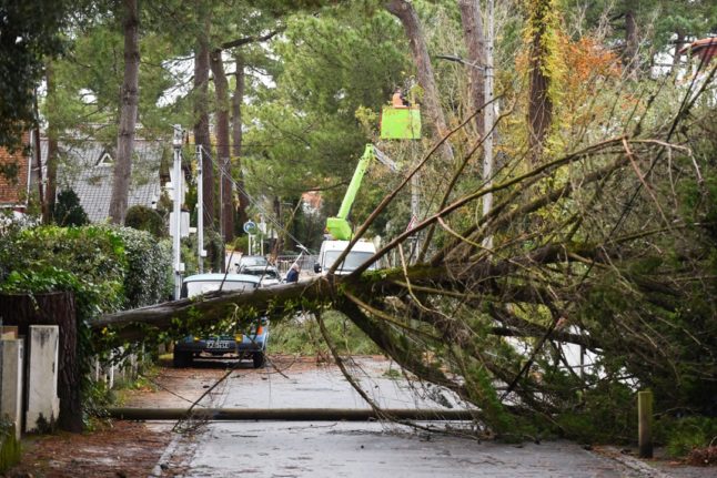
In the worst affected areas – mostly in Brittany – many roads remain closed as local emergency services deal with a very high number of fallen trees.

Red weather alerts were lifted at 10am on Thursday, after the storm left 1.2 million homes without electricity in France, 780,000 of them in Brittany, energy provider Enedis said on Thursday morning.

READ ALSO Severe travel disruption, power cuts and 190km/h winds as Storm Ciaran hits France

Twelve orange weather alerts remain in place – Manche, Seine-Maritime, Oise, Somme, Pas-de-Calais and Nord departments remained on heightened vigilance because of strong winds, which are now ranging between 100km/h and 120km/h.

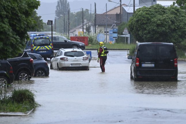
Meanwhile, Corse-du-Sud is on alert for flooding, storms and dangerous sea conditions; Haute Corse for flooding; and Bouches-du-Rhône, Var, Alpes-Maritimes, Pyrénées-Atlantiques, Landes and Calvados were all on alert for dangerous sea conditions, while heavy overnight rain in the south-west will increase flood risks in Landes and Pyrénées-Atlantiques into Friday.

A further 34 départements, along the north coast, west coast and in Alpine regions, are on yellow weather alerts – mostly for high winds, flood risk and heavy rain.

A cold front crossing Corsica overnight is expected to bring heavy rains and storms, as well as strong winds, especially towards the west of the island.

Six départements will remain on orange alert into Friday, according to Meteo France’s Thursday afternoon bulletin. Pas-de-Calais, Landes and Pyrénées-Atlantiques are all on alert for flash flooding caused by intense rain, while stormy showers are forecast to continue on the western side of Corsica, and are set to strengthen in the late afternoon and evening. 

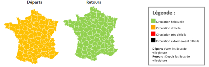
But forecasters have warned that France faces a stormy weekend as another Atlantic depression hurtles towards the country, bringing strong winds and sustained rain, followed by stormy showers on Saturday. Mediterranean areas may be spared the worst of the weekend weather, but people in the region should expect strong mistral and tramontane winds.

Minimum temperatures will range from 7C to 11C in the morning and maximums will range from 12C to 15C.

Unstable weather conditions are expected to continue into Sunday, with heavy, occasionally sleety showers, while winds will be especially strong near the Mediterranean. Heavy snow is forecast in mountainous areas from around 1,200m.

It will be relatively cool with temperatures in the morning between 3C and 8C and maximums between 11C and 15C from north to south.

Member comments

Log in here to leave a comment.
Become a Member to leave a comment.

FRANCE WEATHER

Thunderstorms, floods and traffic: France’s last holiday weekend in May 

The final holiday weekend of May in France is set to be marked by bad weather and difficult driving conditions on busy roads.

Thunderstorms, floods and traffic: France’s last holiday weekend in May 

Monday, May 20th is a holiday for most of France, marking the Christian festival of Pentecost, which means that many people will enjoy a three-day weekend.

This is the last of four public holidays in France in May 2024, now we need to wait until August for another extra day off work (since the Fête National on July 14th falls on a Sunday this year).

So what can we expect for the long weekend? Well, bad weather and heavy traffic, unfortunately.

The Moselle département, in north-east France, was placed on red weather alert on Friday after hours of heavy rain caused flash flooding.

The red weather alert initially runs until 9pm on Friday, with between 80mm and 100mm of rain expected, while between 70mm and 90mm are predicted in the far north of the neighbouring Bas-Rhin, with up to 70mm expected further south – figures national forecaster Météo-France said approached records for daily rainfall figures in the region.

Orange alerts in the area remain in place on Saturday.

Image: Météo-France

Rain and occasional storms, some bringing hail, are expected to develop across large parts of the country throughout the weekend, with only the Mediterranean areas likely to remain dry on Saturday.

Showers and sunny spells will continue into Sunday and Monday, with occasional thunderstorms in the south-west. Temperatures throughout the weekend should rise to between 15C and 22C.

To make family getaways on the final long weekend of the month even more difficult, roads watchdog Bison Futé predicts ‘difficult’, or ‘very difficult’ travel conditions on key routes across the country. 

Image: Bison Fute

On Friday, traffic is expected to be heavy on routes heading away from major cities towards popular holiday destinations until well into the evening – especially on Paris’s Périphérique and the A86 and A6B, the A7, along the Mediterranean Arc and on the Atlantic seaboard (A11, N165 and A63). 

The A13 is likely to remain closed to traffic between Paris and Vaucresson across the holiday weekend, so drivers from the Paris region wishing to reach Normandy are advised to take the A14, A15 or N12

On Saturday, May 18th, conditions on the roads will be difficult nationwide, particularly on roads serving the Mediterranean arc (A7 and A9) and the Atlantic coast (A63 and N165). In the Île-de-France region, traffic will be heavy from early morning onwards on the A6 and A10. From mid-morning onwards, traffic is expected to intensify significantly. 

Image: Bison Fute

Routes converging on the A10 and A6 could also see traffic problems on Saturday, Bison Futé warned.

No major forecastable traffic problems are expected on Sunday – but, on Monday, May 20th, short breakers will be returning home, leading to heavy traffic across the country, notably on A7 and A9, in the Mediterranean region, and routes serving the west of the country.

Traffic will be heavy on the A10 and A6 in the Île-de-France region from late morning into the evening. The A13, which should be open, could also experience traffic problems from mid-afternoon onwards, and could continue to do so well into the evening.

Across the country banks and public administration offices will close. Some independent shops may close, while larger stores and chains are more likely to be open, but probably with altered opening hours.

Most bars, restaurants and cafés will remain open while public transport will run as normal. 

SHOW COMMENTS