SHARE
COPY LINK

HEATWAVE

Parts of Switzerland on red alert as temperatures soar

A number of heat warnings remain in place across Switzerland as temperatures in some areas are expected to rise to 37C.

A boy jumps into Lake Geneva at sunset from a platform off the village of Lutry, western Switzerland on August 9th 2020.
A boy jumps into Lake Geneva at sunset from a platform off the village of Lutry, western Switzerland on August 9th 2020. Switzerland is seeing severely hot weather this week. (Photo by Fabrice COFFRINI / AFP)

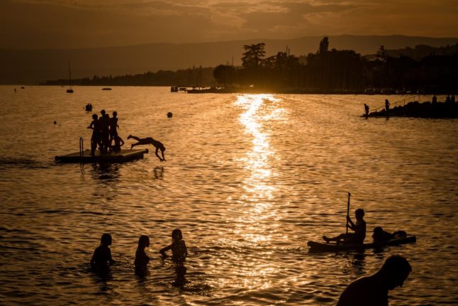
There has been no respite from the extreme heat in Switzerland this week. 

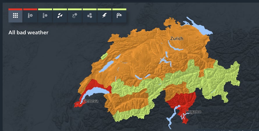
On Wednesday, a red level 4 ‘high danger’ heat warning was issued by MeteoSwiss in parts of southern and western Switzerland, while an orange level 3 ‘considerable danger’ alert was announced for large swathes of the country, as seen below. 

Switzerland's heat alerts on August 23rd.

Switzerland’s heat alerts on August 23rd. Screenshot: MeteoSwiss

Temperatures up to 37C were expected in Geneva on Wednesday, while it was due to hover around 35C in other areas. In Zurich highs of 33C were forecast.   

READ ALSO: What Swiss employees need to know about working in a heatwave

MeteoSwiss said that a temperature record for the second half of August was recorded on Tuesday at several locations, including in Zurich (34.7C) and Geneva (36.7). 

Meanwhile, the highest ever August temperature was recorded at the weather station in Disentis, Graubünden, where the mercury hit 32.8C.

Temperatures have not dropped below 30C during the day in many places since last Friday,

And there have also been ‘tropical nights’ – when the temperature doesn’t fall below 20C during the night, making it very uncomfortable to sleep. 

READ ALSO: Switzerland’s official advice on how to protect yourself in a heatwave

But the heatwave is due to end soon. 

On Friday it will get ever so slightly cooler with a maximum of 30C in Zurich and 32C in Geneva. 

On Saturday temperatures are expected to fall dramatically, with around 22C forecast in the north. 

In the south, the mercury is likely to dip under 30C at the weekend – Lugano is forecast to see 28C and Geneva 25C. But heavy showers and thunderstorms are expected all over the country, especially in the southwest.

From Sunday on, it will be even cooler – in Zurich it will barely reach 20C during the day, and in Bern just 19C.

And in the south, too, the hot summer will take a break: Geneva and Sion will see a maximum of 22C, while Lugano will be warmest at 24C. Again, showers are expected.

According to MeteoSwiss, the weather development from Monday onwards is quite uncertain, but it looks like it will be cooler for a while. 

Member comments

Log in here to leave a comment.
Become a Member to leave a comment.

WEATHER

IN PICTURES: ‘Exceptional’ Sahara dust cloud hits Europe

An "exceptional" dust cloud from the Sahara is choking parts of Europe, the continent's climate monitor said on Monday, causing poor air quality and coating windows and cars in grime.

IN PICTURES: 'Exceptional' Sahara dust cloud hits Europe

Copernicus Atmosphere Monitoring Service said the latest plume, the third of its kind in recent weeks, was bringing hazy conditions to southern Europe and would sweep northward as far as Scandinavia.

Mark Parrington, senior scientist at Copernicus, said the latest event was related to a weather pattern that has brought warmer weather to parts of Europe in recent days.

“While it is not unusual for Saharan dust plumes to reach Europe, there has been an increase in the intensity and frequency of such episodes in recent years, which could be potentially attributed to changes in atmospheric circulation patterns,” he said.

This latest episode has caused air quality to deteriorate in several countries, Copernicus said.

The European Union’s safe threshold for concentrations of PM10 — coarser particles like sand and dust that that can irritate the nose and throat — has already been exceeded in some locations.

A picture taken on April 8, 2024 shows a rapeseed field under thick sand dust blown in from the Sahara, giving the sky a yellowish appearance near Daillens, western Switzerland. – An “exceptional” dust cloud from the Sahara is choking parts of Europe, the continent’s climate monitor said, causing poor air quality and coating windows and cars in grime. (Photo by Fabrice COFFRINI / AFP)

The worst affected was the Iberian Peninsula in Spain but lesser air pollution spikes were also recorded in parts of Switzerland, France and Germany.

READ ALSO:

Local authorities in southeastern and southern France announced that the air pollution threshold was breached on Saturday.

They advised residents to avoid intense physical activity, particularly those with heart or respiratory problems.

The dust outbreak was expected to reach Sweden, Finland and northwest Russia before ending on Tuesday with a shift in weather patterns, Copernicus said.

The Sahara emits between 60 and 200 million tonnes of fine dust every year, which can travel thousands of kilometres (miles), carried by winds and certain meteorological conditions.

The Spanish Canary Islands off the coast of northwest Africa saw just 12 days within a 90-day period from December to February where skies were free of Saharan dust, the local weather agency Aemet had reported.

SHOW COMMENTS