After days of heavy rain resulted in deadly flooding in northern Italy, the short-term forecasts showed few signs of improvement.
More rain was forecast for the northeastern Emilia-Romagna region in the coming days, after this week’s floods claimed 14 lives and caused widespread devastation.
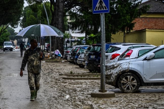
READ ALSO: Italy’s flood death toll rises to 14 as government urged to act on climate
Parts of the northeastern region remain on the highest-level ‘red’ alert for extreme weather events on Saturday, Italy’s civil protection agency confirmed.
Other parts of the region, along with Piedmont, Calabria, and Sicily, were placed on a medium-level amber alert.
🔴🔔#AllertaROSSA, #20maggio, su parte dell'#EmiliaRomagna. #AllertaARANCIONE in 5 regioni e #allertaGIALLA in 11 regioni.
Previsti venti forti al Sud. Pioggia e temporali su Nord-Ovest, Sardegna e regioni meridionali. Leggi l'avviso meteo #19maggio 👉 https://t.co/rJUrbdL20P pic.twitter.com/WJYmZYaSVv— Dipartimento Protezione Civile (@DPCgov) May 19, 2023
Parts of the Marche region, south of Emilia Romagna, were under a lower-level yellow alert after it also suffered flooding in some areas this week.
The civil protection agency said the risk of landslides was considered high in Emilia Romagna, where there are also concerns that the levels of already swollen river levels will rise further.
There have already been 290 landslides reported in the region this week, officials in the Emilia Romagna region said on Friday.
The number of floods had reached 58, in 43 municipalities. 544 roads remained totally closed.
Landslides were also possible in parts of the Piedmont region, the agency said, where two provinces were under a lower-level ‘yellow’ alert.
READ ALSO:
- Why has flooding in northern Italy been so devastating?
- Floods in Italy: What to do when there’s a weather warning
- IN VIDEOS: How floods devastated Italy’s Emilia-Romagna region
No weather warnings were issued elsewhere in the country, though it was set to be another wet and windy weekend with rain forecast everywhere from Turin and Milan in the north to Rome in the centre and across the southern regions of Puglia and Basilicata.
Forecasters also said sirocco winds from northern Africa would carry sand from the Sahara across much of Italy in the coming days, which combined with the rain was likely to leave everything coated in yellow-brown dust.
Long-range forecasts predicted unusually rainy and unsettled weather was likely to continue across Italy until at least the end of May.
Rain would then be followed by intense heat at the start of summer due to anticyclones moving in from Africa, forecasters said.


Member comments