SHARE
COPY LINK

TRANSPORT

Copenhagen Marathon: How to avoid transport delays on race day

Copenhagen’s annual marathon takes place on Sunday May 14th with a new route and around 12,500 runners expected to take part.

Copenhagen Marathon: How to avoid transport delays on race day
Around 12,500 runners will take on the marathon in Copenhagen on May 14th, meaning some disruptions for cars and cyclists. Photo: Philip Davali/Ritzau Scanpix

Roads will be closed in each of the capital’s central districts of Østerbro, Vesterbro, Nørrebro and Inner City, as well as in Frederiksberg, on the day of the race.

Cars will not be permitted to drive on the marathon route until it is reopened, including at times when there are no runners on those sections. As such, drivers should park outside the city centre and head in via public transport, or choose routes that avoid the centre if crossing Copenhagen.

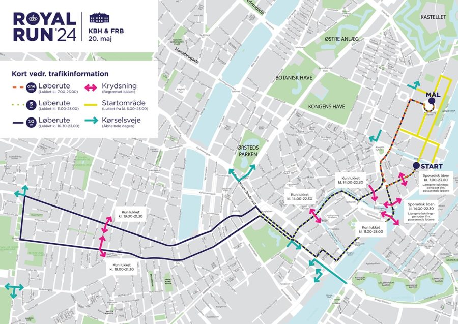
Streets included on the route will be reopened in sections after runners have passed them, Copenhagen Marathon states in its traffic advice ahead of Sunday’s race.

A full map of the marathon route can be found here, including a list of points where cars can cross the marathon route. Drivers should be aware that these points may not always be open while the race is ongoing.

Residents and visitors to the city are advised to use the Metro, S-train and regional train services wherever possible, as these are unaffected by the event. Bus routes are likely to be diverted or cancelled.

If you are heading across town by bicycle or on foot, you will be able to cross the course when there are no runners. This might require walking alongside it for a while to find a gap and to wait for a break in participants. Race marshals can provide instructions for crossing.

Two bicycle bridges crossing Copenhagen Harbour, the “Cykelslangen” from Fisketorvet to Dybbølsbro; and the “Lille Langebro” between Islands Brygge and the Danish Architecture Centre and Royal Library, will both be closed from 7am to 4pm. The harbour can instead be crossed via the main Langebro bridge.

The 2023 Copenhagen Marathon is the 42nd edition of the event, which was cancelled in 2020 and 2021.

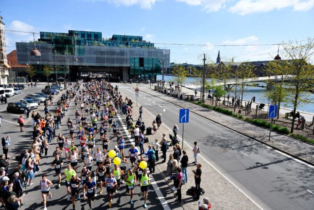
Its route through the city has been updated for this year, with the start and finish area now at Øster Allé near Fælledparken, instead of by the harbour at Islands Brygge as in past editions. The classic 42.2 kilometre (26 mile) distance will take marathoners past Tivoli, Christiansborg and Kongens Nytorv, with the Round Tower and Nyhavn among landmarks from the old route that have been dropped.

Race organiser Sparta says the new route is flatter and therefore hopes for new course records to be set on Sunday, helping position the Copenhagen Marathon as the fastest and most attractive marathon in the Nordic region.

Member comments

Log in here to leave a comment.
Become a Member to leave a comment.
For members

TRAVEL NEWS

How will traffic be affected by Monday’s Royal Run in Copenhagen and Aarhus?

About 95,000 people are taking part in the Royal Run in Copenhagen, Aarhus, Fredericia, Kalundborg and Brønderslev. Here's how traffic will be affected in Denmark's two biggest cities.

How will traffic be affected by Monday's Royal Run in Copenhagen and Aarhus?

In Copenhagen, traffic will be diverted away from all the streets around the starting area at Amalienborg Palace between 6am and 11pm, with the first part of the race route (Orange on map below) closed from 7am and 11pm, a broader area including HC Andersens Boulevard closed from 2pm to 10.30pm (green below) and a much larger route closed from 4.30pm and 11pm.  

The map of how the Royal Run will affect traffic in Copenhagen. Photo: Royal Run
 

Cars will also be banned from stopping or parking on Frederiksberg Allé,  Amaliegade, Toldbodgade, St. Annæ Plads, and Holbergsgade between Nyhavn and Herluf Trolles Gade.

In Fredericiagade between Amaliegade and Bredgade, the stopping and parking ban already applies from Sunday 19 May at 8.00am to Tuesday 21 May at 10am. 

The race organisers are recommending that people either come by public transport or cycle to the start area, as no areas have been arranged for parking in the city.

They recommend travelling by metro to Kongens Nytorv or Marmokirken, by harbor ferry to Nyhavn, or by metro or S-train to Østerport, and then walking the rest of the distance. 

Those participating in the race are being offered a cheap ticket on public transport, costing 33 kroner for zones 1 to 4 or 66 kroner for unlimited zones, which is valid for 24 hours. 

Aarhus

Some 20,000 people will be participating in the run in Aarhus, with quite a significant impact on traffic in the city. 

Large parts of the city centre will be closed to car traffic between 10am and 5pm, with the areas immediately around the start and finish line closed from 7am (click on the red areas in the map below to see times when areas are closed to car traffic). 

In the guide to traffic issued by the run’s organisers, people travelling into the city by car from the north are advised to park their cars at the Navitas car park, and then get buses 16 or 18 from Nørregade into the city centre. 

 
People travelling in by car from the south and west advised to park at the Jydsk Væddeløpsbane, on Observatorivevejen 2, from where it is a 15 minutes walk to the star area. 
 
Those travelling from the south are also advised to use the car parks next to Aarhus Stadium.
 
 
SHOW COMMENTS