Several times already this year, strong solar activity has meant that the elusive Northern Lights have already blanketed Norway’s night sky this year.
Following a dazzling display of green, purple and red over Norway on Sunday, the presence of the aurora will continue throughout much of the country over the next week.
The bad news is that those in southern Norway and Oslo will likely miss out.
READ MORE: Strong Northern Lights to continue over Norway this week
The good news for those hoping to catch a glimpse of the lights in Norway is that their presence will become much more intense in the coming years, according to experts.
The Northern Lights are triggered by strong geomagnetic activity. The northern parts of the Earth are divided into KP zones. The zones range from one to nine. For example, Tromsø, in the north, is in KP1, and southern Norway is in KP5. The stronger the geomagnetic activity, the higher the KP number, and the further south the lights can be seen.
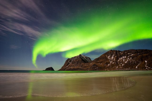
The Northern Lights are caused by streams of charged particles from the sun, which penetrate the Earth’s atmosphere and collide with gas molecules, which then release photons of light.
The type of molecule, along with the altitude of the collisions, determines the colour of each aurora. The most common are green from oxygen molecules around 120 to 180 kilometres up. Less frequent are red auroras, generated from oxygen around 200 km above the ground, while red-purple auroras come from nitrogen closer to the planet’s surface.
Red and purple auroras are much more frequent during instances of high solar activity.
Intense solar activity and solar winds contribute to the presence of the Northern Lights. In the coming years, there will be much more solar activity, meaning more intense Northern Lights activity.
“The sun has an 11-year cycle, and now we are approaching the peak of activity. It is likely to be a great winter with a lot of northern lights ahead,” Njål Gulbrandsen, researcher at the Tromsø Geophysical Observatory at the University of Tromsø, told NRK.
Essentially, the sun has an activity cycle that lasts around 11 years. In the coming years, the sun will enter a stage of plenty of solar activity. This increases the frequency of solar storms and coronal holes (holes in the sun’s atmosphere), leading to more intense appearances of the northern lights.
This winter will see the Northern Lights the strongest they have been in at least a decade. The current cycle is expected to peak in 2024 or 2025.
As this activity reaches its peak, the intensity and frequency of the Northern Lights will increase.
For those hoping to see the Northern Lights, it’s worth remembering that other factors come into play. Weather conditions such as cloud coverage, and light pollution, all limit the possibility of seeing the lights.
To maximise your chances you will need to check the weather as well as the KP coverage. Norway’s Yr weather app has an aurora forecast function that offers both a KP forecast and a cloud coverage forecast, helping you identify your chances of seeing the Northern Lights.
READ ALSO: How to take the best pictures of the Northern Lights

Member comments