SHARE
COPY LINK

WEATHER

Storms Dudley and Eunice set to bring 140 km/h winds to northern France

Winds of up to 140 km/h are forecast when storms Dudley and Eunice hit northern France.

Storm waves crash into the sea wall of a town in northern France
Photo: Philippe Huguen / AFP

A month of relative weather peace ended this week after an anticyclone that protected the country for more than a month dissipated, leaving the country at the mercy of winter Atlantic weather conditions

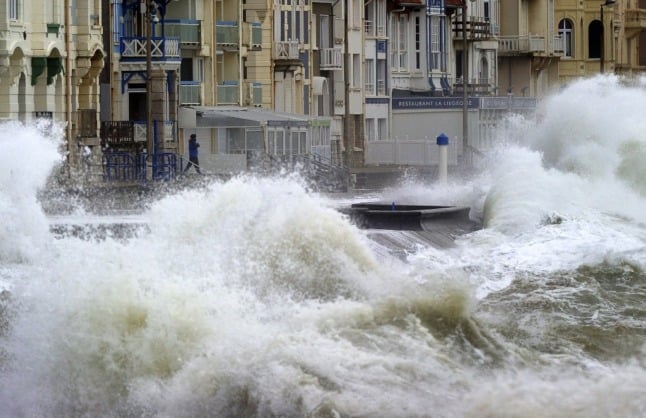
Storms Dudley and Eunice are forecast to sweep over Ireland, then into the UK before heading into Europe – and the north of France should brace for strong winds on Wednesday night into the early hours of Thursday, and again on Friday.

The French have already witnessed a return of rainy intervals, turning wintry at higher altitudes following the break-up of the anticyclone’s ‘weather shield’.

Dudley will be the first storm to affect northern reaches of France, bringing some heavy rain and winds gusting up to 110kph overnight on the hauteurs de l’Artois and Pays de Caux, upper Normandy, and across Hauts-de-France from 10pm until about 2pm. 

Winds of up to 80kph are to be expected from Lower Normandy across to the Grand Est.

After a lull on Thursday, the more powerful Storm Eunice is set to track across a similar path on Friday, bringing wind gusts of up to 120kph in the Nord, Pas-de-Calais and Somme, rising to 140kph along the coast.

From Normandy to the Ardennes, windspeeds of up to 100kph are forecast, while further south, from Brittany and Pays-de-la-Loire to the Grand Est, the gusts can reach 80 or even 90kph.

A storm surge of between 30cm and 40cm is expected along northern coasts at high tide on Friday – though that is not as high as the 1m envisaged along the coast of the Netherlands, further north, where worse conditions are predicted.

Member comments

  1. Pingback: Anonymous
Log in here to leave a comment.
Become a Member to leave a comment.
For members

ENVIRONMENT

How likely are droughts and water restrictions in France in summer 2024?

Much of France has faced severe flooding this winter, but other areas already face water restrictions, and there's an extra variable in store global weather patterns play their part

How likely are droughts and water restrictions in France in summer 2024?

France’s Bureau de Recherches Géologiques et Minières (BRGM) most recent report, in early March, revealed that the water table in France was ‘satisfactory over a large part of the country’, with levels above normal for the time of year in 46 percent of the country’s underground aquifers.

It warned at the time, however, that levels were low to very low in parts of Alsace, as well as in the Saône corridor and areas of Languedoc, from the south of the Massif Central to the coast, and the Roussillon area of southwest France.

March, too, was a wet month across the bulk of France – it was the fifth wettest since records began in 1958, according to national forecaster Météo-France.

Crucially however, most of the rain falling on the ground in France now will be gobbled up by vegetation, which means that very little water will make it through to aquifers. The groundwater recharge period, when underground water tables are refilled, is now over until late autumn 2024.

Basically, the water table is about as high as it’s going to get this summer.

Which brings us back to the weather.

Long-range forecasts are notoriously inaccurate but after a mild, wet winter, forecasters expect another dry, warm summer overall, following a cooler-than-normal and occasionally wet spring.

April, for example, is set to be marked by cool spells, though, for the April-May-June quarter as a whole, temperatures are expected to remain above seasonal averages. Forecasters warn that a higher-than-usual number of Spring storms could affect the south-east of the country.

Long-range models suggest, however, that June could be hot and dry, with consequences for agriculture – though groundwater levels should be high enough to cope comfortably.

Forecasting further into the summer is even less certain than normal because – over in the Pacific – El Nino is expected to be replaced by La Nina much faster than normal, making weather prediction difficult. 

The consensus is, however, that the cooling effect of La Nina will not be felt until much later in the year. That said, it will have a more immediate effect on weather activity in the North Atlantic. Forecasters are already predicting a record-breaking hurricane season – which will have an effect on French weather patterns.

Between May and July, forecast temperatures in France are likely to remain 1C to 2C above seasonal averages. Precipitation is expected to be fairly close to average, with a tendency for thunderstorms, especially in the south.

Forecast models predict a wet end to April, a fine and dry May, a hot and occasionally thundery June, and a warmer-than-normal July punctuated by thunderstorms – though some forecasts suggest more mixed weather in the north in the seventh month.

With water tables currently well recharged, the national water situation for the summer is, right now, giving experts little cause for concern. 

Thunderstorms are expected to provide occasional watering to limit surface drought, which is always possible even if water tables are well recharged. The summer of 2024 therefore looks set to be different from recent droughts. 

However, this is not to say water restrictions are not impossible, or even unlikely. In certain areas, notably the Aude and Pyrénées-Orientales, where rainfall has been well below average for years, the situation is already serious.

While the rest of the country saw high rainfall in March, these two départements were recording 50 percent less rain than normal.

These areas are already facing a range of water restrictions. To find out whether restrictions are in place where you live, consult the Vigieau website, which offers information on a national, regional and local level.

SHOW COMMENTS