Residents in the areas are advised to seek shelter indoors and stay away from rivers or trees during a storm.
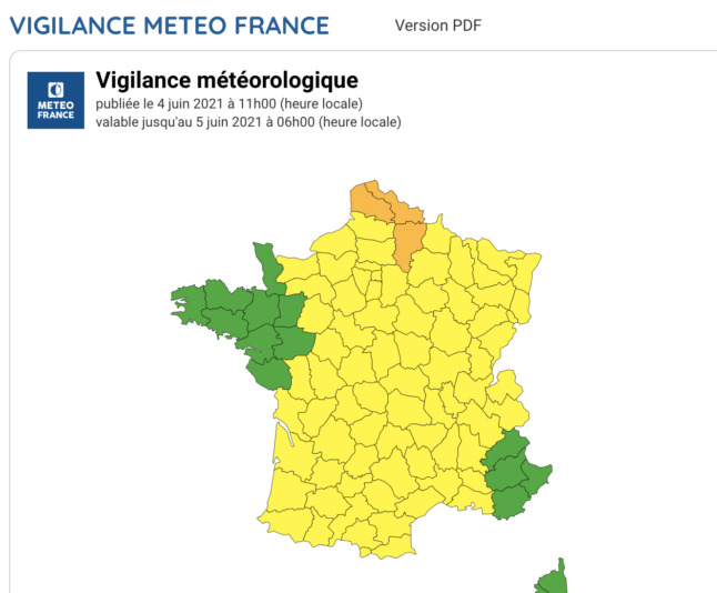
And forecasters have warned that, after a few days of rising temperatures, storms are expected throughout the day on Friday.
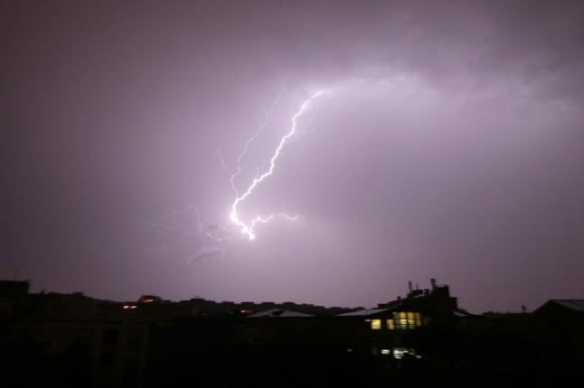
Residents in the capital will be well aware of the conditions as storms hit early this morning as the system spread west.
⚡️ Le photographe @prenard a capturé ce matin vers 4h33 un coup de #foudre sur la #TourEiffel ! Cela se produit 4 à 5 fois par an en moyenne, la Tour Eiffel étant l’un des plus hauts paratonnerres artificiels de France… @LCI #Paris #orage pic.twitter.com/LYnx4Xf5BO
— Guillaume Woznica (@GWoznica) June 4, 2021
And day very quickly turned to night as the conditions continued into rush hour.
Un #orage d'une rare intensité a touché #Paris vers 7h30 avec des #pluies diluviennes : il est tombé 16 mm en moins d'un quart d'heure. Résultat : près de 300 km sur les routes d'#IledeFrance. En images accélérées, l'arrivée de l'orage vue depuis la caméra du toit de la tour @TF1 pic.twitter.com/uOkfeFx5ZQ
— Guillaume Woznica (@GWoznica) June 4, 2021
C’est normal ça??? #orageparis #orage #paris #pluie #inondation pic.twitter.com/GstmEHNlJH
— jacques hadi (@MinisteredesAe) June 4, 2021
A quarter of an hour was all it took for the deluge in several communes across the Seine-et-Marne department, flooding 90 houses in the 800-population village of Thieux on Wednesday.
Twenty-four hours later, residents – who had spent the day cleaning up – were forced to evacuate again, as the storms returned.
Thieux : reprise d'orage en fin de soirée, pas de secours à victimes mais une cuvette plus importante qu'hier (@Sdis77) pic.twitter.com/IrvkE7NiKk
— Seine-et-Marne (@Departement77) June 3, 2021
The nearby communes of Messy, Gressy, Villeroy and Cherny were also hit as the storms battered large parts of the country.
This afternoon, heavy thunderstorms will extend from the Paris Basin towards Hauts-de-France, Champagne-Ardenne and Lorraine.
Further south, storms will develop in the Pyrenees and spread deeper into the Occitanie. The weather will also become very unstable from Limousin to Auvergne with sometimes strong thunderstorms.
Overnight, powerful storms are forecast to hit Occitanie and Auvergne, while a few thunderstorms will still affect the regions north of the Seine, mainly between Hauts-de-France and Lorraine.
Member comments