Satelite footage shot by NASA shows the cloud of sand sweeping over the Canary Islands from the Sahara.
Imágenes de satélite de la tormenta de arena que están sufriendo las Islas #Canarias • pic.twitter.com/xtfNS5iCbW vía @apuntoratge #VideoCiencia #calima
— Apuntes de ciencia (@ApuntesCiencia) February 22, 2020
And the forecast shows the phenonmenon is set to continue until Wednesday.
Forecast indicating that it not be until Wednesday until the clearer air fully replaces the dust-laden skies currently in place #duststorm #sandstorm pic.twitter.com/tzhcQYGCsf
— Matt Taylor (@MetMattTaylor) February 24, 2020
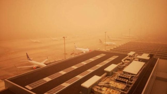
The dust cloud closed airspace over the Canary Islands and bathed eveything in an orange hue.
This image was shot from the air traffic control tower at one of the airports on the archipelago.
Días muy difíciles en el espacio aéreo canario por la presencia de calimas que dificultan la operativa, pero ¿por qué? ¿Cómo influye el polvo en suspensión en el vuelo de los aviones?
Os lo explico en este HILO ??@controladores pic.twitter.com/6KCAOlZ7JA
— Julio Morillas (@J_Morillas) February 23, 2020
And here's some footage ofGran Canaria looking like a scene from Lawrence of Arabia but with a bicycle in place of a camel.
God loves a tryer… ? ? #Famara #Calima #Lanzarote pic.twitter.com/65ztZQclxa
— Lanzarote Chic (@ChicLanzarote) February 22, 2020
The scene was repeated across the Canary Islands, from Gran Canaria to Tenerife to Lanzarote.
Outside Gran Canaria airport today #duststorm #calima pic.twitter.com/8ylEeYeG4A
— Ben Adams (@bennyaddo) February 23, 2020
Worst #dust #storm #calima in the last 30 years turned #Tenerife into #Mars. Visibility is under 800m. Airports are closed. pic.twitter.com/EI8erGaMuc
— Helen N (@cryptoHelen) February 23, 2020
¡Brutal! Las imágenes de las islas Canarias son de distopía de ciencia-ficción. CANARIAS 2049. #Calima #Sandstorm pic.twitter.com/wlJATa2U3k
— Ivanovitch ?? (@Johnny_Boy_37) February 24, 2020
And here's a shot of Las Canteras beach on the island of Las Palmas.
Así se ve la playa de Las Canteras en Las Palmas.pic.twitter.com/Kwp31PY1kR
— Airam Fernández (@Shiva_dilan) February 23, 2020
Island authorities have declared a red alert and issued a list of recommendations which include closing doors and windows, drink lots of liquids and avoid exertion. Those who suffer from respiratory problems are advised to stay indoors and drivers are told to be careful on the roads, use headlamps and cut speed as visibility is greatly reduced.
#Calima Recomendaciones @112canarias:
-Cerrar puertas y ventanas
-No salir si sufre enfermedad respiratoria
-Beber mucho líquido
-Evitar el ejercicio severo
-Precaución al volante, encender luz y reducir velocidad
-Tener medicamentos habituales
-Acudir al médico si se siente mal pic.twitter.com/EFpoxH9wOp— Cabildo Gran Canaria (@GranCanariaCab) February 22, 2020

Member comments