SHARE
COPY LINK

WEATHER

Southeast France on red alert again as ‘dangerous’ floods and heavy rainfall storm in

Just a week after torrential floods claimed the lives of six people on the French Riviera, the southeastern departments of Var and Alpes-Maritimes were hit again by a “dangerous meteorological phenomenon” on Sunday.

Southeast France on red alert again as 'dangerous' floods and heavy rainfall storm in
Météo France fears a repeat of last week's floods in southeast France, as seen in this photo (weather map insert: Sunday Dec 1st forecast). Photo: AFP/Météo France

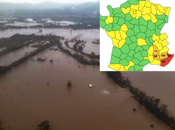
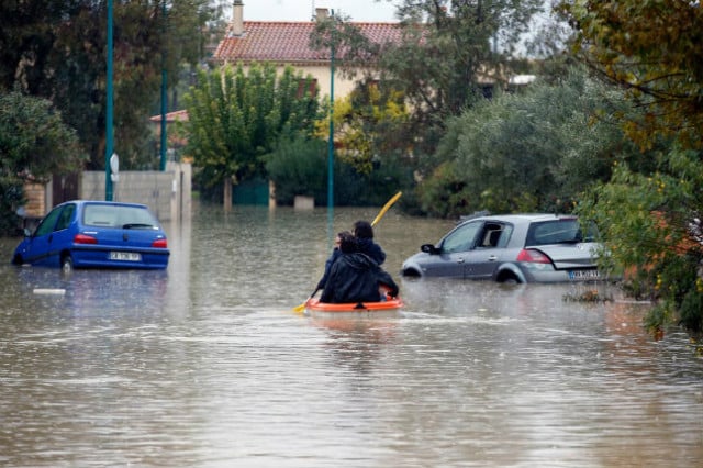
Heavy rain and storms returned to southeast France on Sunday, with national weather agency Météo France placing the departments of Alpes-de-Haute-Provence, Drôme and Vaucluse on orange alert and Var and the Alpes-Maritimes on red alert for flood and thunderstorm risk.

Torrential rain of “exceptional intensity” began in the early hours of Sunday throughout the Rhone Valley. The storm eventually drifted to the Alpine regions and western Provence by the morning and rainfall is expected to continue throughout much of Sunday.

Météo France has forecast up to 100mm of rainfall/sqm across “most of the southern half of the Var”, and between 80mm/ and 200mm/sqm in Alpes-Maritimes.

Vaucluse is expected to get between 20 and 80mm/sqm, with the heaviest rainfall forecast for the south and west of the department.

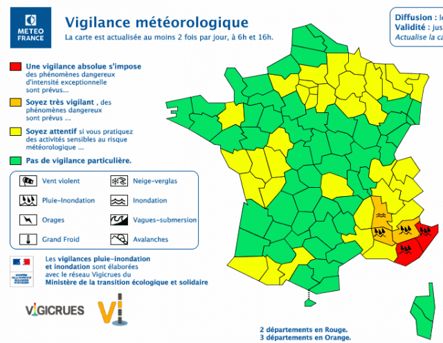
France’s public forecaster has warned against all forms of travel in the most affected departments, writing: “very serious flooding is possible. Driving conditions on the roads may be extremely difficult, visibility will be reduced and there may be considerable disruption to train travel”. 

The ominous weather announcement comes just a week after another spell of torrential downpours and floods in south-east France cost six people their lives, including a couple whose car was swept away in rising waters. 

Member comments

Log in here to leave a comment.
Become a Member to leave a comment.

WEATHER

Norway to get a taste of summer with 20C days this week

Summer is finally here! Or least it is if you live in southern Norway, where a warm front coming up from Europe will bring t-shirt temperatures of 20C by Thursday, according to forecasts.

Norway to get a taste of summer with 20C days this week

Warm air from southern Europe will combine with a high pressure zone which will bring clear skies and sunshine, with summery weather coming towards the end of the week, Norway’s national weather forecaster Yr has reported. 

“Thursday and Friday especially will be nice,” Ingrid Villa, a meteorologist at the Norwegian Meteorological Institute, told the public broadcaster NRK. “Then we will probably get temperatures of over 20 degrees Celsius in some places.” 

Patches of 20C warmth are expected both in western Norway around Bergen and in Western Norway around Oslo, with the area around Tromsø expected to have slightly cooler weather, although Villa said that “it will absolutely be something like summer there too”. 

The warm sunny weather is, however, expected to pass northern Norway by, with grey overcast skies expected for much of this week. 

But if you think summer has come to Norway to stay, you risk disappointment as much cooler temperatures are expected next week.  

“There’s nothing unusual in getting an early taste of summer in April and the start of May, and then we can quickly go back to cooler more spring-like weather,” Villa said. 

SHOW COMMENTS