SHARE
COPY LINK

CLIMATE

Climate protesters block Geneva’s private jet terminal

Dozens of climate activists blocked access to the private jet terminal at Geneva airport Saturday, demanding a halt to the "absurd" mode of luxury transportation.

Climate protesters block Geneva's private jet terminal
Photos: AFP

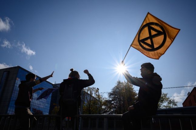
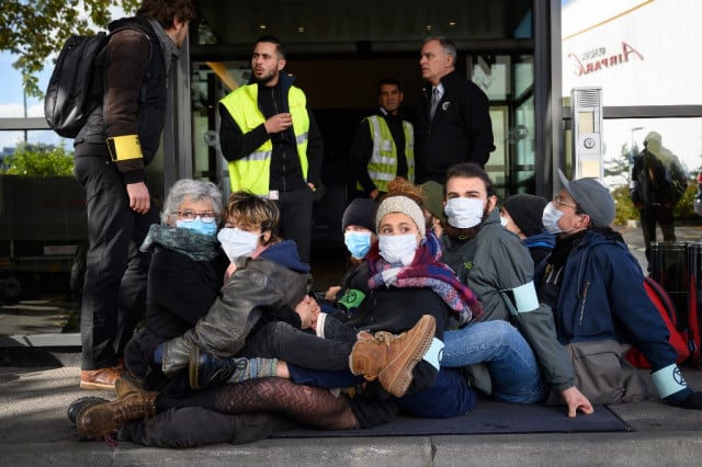
Around 100 people took part, organised by pressure group Extinction Rebellion, large groups sitting in front of three entrances to block access to the building for several hours.

Extinction Rebellion describes itself as an international movement using non-violent civil disobedience “to achieve radical change in order to minimise the risk of human extinction and ecological collapse”.

As musicians played, protesters wearing armbands with the Extinction Rebellion logo sang songs and danced around with white, cloud-shaped placards and banners with slogans like “Be part of the solution, not pollution”.

“We are facing a total climate emergency,” Extinction Rebellion spokesman Micael Metry told AFP.

“Private jets emit 20 times more CO2 per passenger than normal airplanes,” he said.

“It is very important for us to denounce this completely absurd and unjust means of transportation, which is used by a tiny fraction of the population.”

Sonia Ediger, who said she had come from Lausanne to take part in the protest, called on the “powerful people of the world” who fly private jets “to come down out of the clouds”.

“We are seeing the world collapse around us, we see catastrophe after catastrophe, ever bigger, ever more frequent, all around us,” she told AFP, insisting that “radical change” was needed.

A large number of Geneva police, some in riot gear, assembled to monitor the unauthorised protest, but kept their distance for several hours.

At mid-afternoon, police asked the demonstrators to identify themselves and then leave in small groups, which they did peacefully.

Police spokesman Silvain Guillaume-Gentil told the ATS news agency they had not yet decided whether to bring charges.

Member comments

Log in here to leave a comment.
Become a Member to leave a comment.

CLIMATE

Central and southern Italy brace for storms and heavy snow

Storms and snowfall are forecast across much of central and southern Italy over the next few days, according to weather reports.

Snow is forecast in the hills of much of central and southern Italy.
Snow is forecast in the hills of much of central and southern Italy. Photo: Miguel MEDINA / AFP

Italy’s Civil Protection Department on Monday issued ‘orange’ alerts for bad weather along Campania’s Tyrrhenian coastline and the western part of Calabria, while Sicily, Basilicata, Lazio, Molise, Umbria, Abruzzo, central-western Sardinia, and the remaining areas of Campania and Calabria are under a lower-level ‘yellow’ weather warning.

The European Centre for Medium-Range Weather Forecasts is warning Italy’s central-southern regions to prepare for a blast of polar air from the Arctic Circle that will bring heavy snowfall, rain and storms, reports national weather forecaster Il Meteo.

The village of Grotte di Castro in the province of Viterbo, two hours’ drive north of Rome, mountainous parts of Sardinia, and much of the province of Campobasso in the central-eastern region of Molise were already blanketed in snow on Monday morning.

The department is responsible for predicting, preventing and managing emergency events across the country, and uses a green, yellow, orange and red graded colour coding system for weather safety reports.

An orange alert signifies a heavy rainfall, landslide and flood risk, while a yellow alert warns of localised heavy and potentially dangerous rainfall.

The current meteorological conditions mean that snow is expected to reach unusually low altitudes of around 450-500 metres, with flakes already falling thickly on parts of the southern-central Apennines mountain range at 500-700 metres altitude.

The hills of Marche, Abruzzo, Molise, Lazio, Sardinia, Campania, Calabria and Basilicata are likely to see heavy snow around the 500m mark, while areas at an altitude of 1000m or higher will see between 50-60 cm of fresh snow.

Affected parts of the country could see 50-60cm of snowfall.

Affected parts of the country could see 50-60cm of snowfall. Photo: Vincenzo PINTO /AFP

In areas where the snow is unlikely to reach, heavy rains and thunderstorms are anticipated, with rain forecast throughout Sardinia, Campania, Calabria and Lazio, reports Il Meteo.

Strong winds are forecast over the whole country, with the island regions of Sicily and Sardinia facing windspeeds of over 100km/hour and the risk of storm surges, according to the national newspaper La Repubblica.

READ ALSO: Climate crisis: The Italian cities worst affected by flooding and heatwaves

The north of the country, meanwhile, will see sun but low temperatures of below 0°C at night in many areas, including across much of the Po Valley.

While conditions are expected to stabilise on Tuesday, cold currents from Northern Europe are forecast to trigger another wave of bad weather on Wednesday and Thursday, with Sardinia and Italy’s western coastline again at risk of storms and heavy rainfall that will move up towards Lombardy, Emilia Romagna and Veneto in the north.

SHOW COMMENTS