SHARE
COPY LINK

WEATHER

Violent storms hit France, with winds of 113 km/h recorded

After an unseasonably warm weekend - with temperatures getting up to 32C in some parts of France - the western half of the country is set to be battered by storms.

Violent storms hit France, with winds of 113 km/h recorded
Lightning over Bordeaux. Illustration photo: AFP

A total of 46 départements are on orange alert – the second highest alert – for violent storms which hit southern France this afternoon and are moving north.

Winds of 113 km/h have been recorded in Mayenne this afternoon, with 93 km/h gusts in Landes and Maine et Loire, while Nantes received 16mm of rain in just one hour.

French weather forecaster Météo France has issued the warning starting at 2pm on Monday for heavy rain, strong winds and electrical storms.
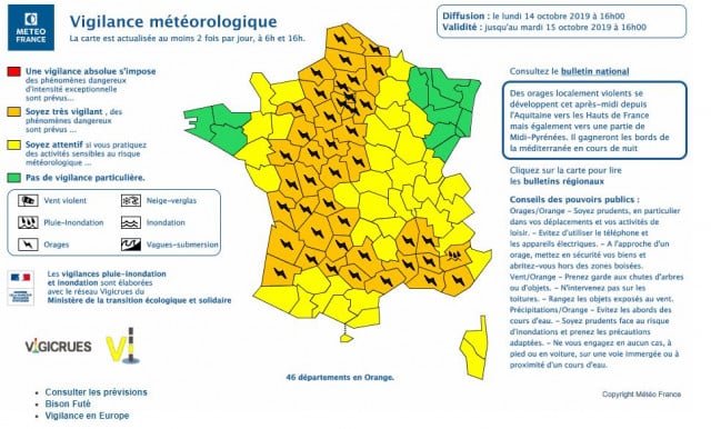
Map: Météo France

The weather forecaster stated: “In the afternoon on Monday, an active storm will enter Aquitaine and spread north east to gradually affect the Charentes, Poitou, western Limousin, central and southern Pays-de-la-Loire, and finally to Ile de France and the Hauts de France in the evening.

At the same time in the southern part the storms will spread to the shores of the Mediterranean in the middle of the night.
 
“High rainfall intensities are expected over a short period of time, between 20 and 30 mm, hail and strong gusts of wind, up to 110 km/h locally.
 
“This will continue in the evening and the following night towards the départments further east.”
 
The départements covered by the warning are: “Charente, Charente-Maritime, Cher, Dordogne, Eure-et-Loir, Gironde, Indre, Indre-et-Loire, Landes, Loir-et-Cher, Loiret, Maine-et-Loire, Orne, Sarthe, Deux-Sèvres, Vienne, Haute-Vienne, Aisne, Aveyron, Bouches-du-Rhône, Corrèze, Eure, Gard, Hérault, Lot, Lot-et-Garonne, Nord, Oise, Pas-de-Calais, Paris et petite couronne, Seine-Maritime, Seine-et-Marne, Yvelines, Somme (80), Tarn (81), Tarn-et-Garonne (82), Vaucluse, Essonne, Val-d'Oise, Alpes-de-Haute-Provence, Ardèche, Drôme and Var. 
 

Member comments

Log in here to leave a comment.
Become a Member to leave a comment.

WEATHER

Norway to get a taste of summer with 20C days this week

Summer is finally here! Or least it is if you live in southern Norway, where a warm front coming up from Europe will bring t-shirt temperatures of 20C by Thursday, according to forecasts.

Norway to get a taste of summer with 20C days this week

Warm air from southern Europe will combine with a high pressure zone which will bring clear skies and sunshine, with summery weather coming towards the end of the week, Norway’s national weather forecaster Yr has reported. 

“Thursday and Friday especially will be nice,” Ingrid Villa, a meteorologist at the Norwegian Meteorological Institute, told the public broadcaster NRK. “Then we will probably get temperatures of over 20 degrees Celsius in some places.” 

Patches of 20C warmth are expected both in western Norway around Bergen and in Western Norway around Oslo, with the area around Tromsø expected to have slightly cooler weather, although Villa said that “it will absolutely be something like summer there too”. 

The warm sunny weather is, however, expected to pass northern Norway by, with grey overcast skies expected for much of this week. 

But if you think summer has come to Norway to stay, you risk disappointment as much cooler temperatures are expected next week.  

“There’s nothing unusual in getting an early taste of summer in April and the start of May, and then we can quickly go back to cooler more spring-like weather,” Villa said. 

SHOW COMMENTS