SHARE
COPY LINK

CLIMATE

Heatwave threatens to accelerate ice melt in Greenland

As Europe's record-breaking heatwave drifts towards the Arctic it threatens to accelerate the melting of ice in Greenland, which already started earlier than normal this year, climate scientists warned Saturday.

Heatwave threatens to accelerate ice melt in Greenland
File photo: Christian Brøndum / Ritzau Scanpix

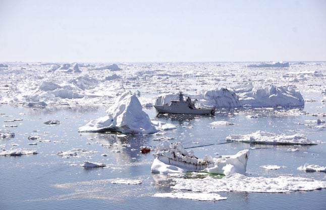
After breaking records over Europe, the heatwave has swept over Scandinavia and is predicted to move towards Greenland, according to the World Meteorological Organization.

“As it is forecast to move over the Arctic it will potentially bring a large amount of energy that will melt ice, both sea ice in the Arctic Ocean and the ice sheet surface over the next 3 to 5 days,” Ruth Mottram, a climate scientist with the Danish Meteorological Institute (DMI), told AFP.

That heat will add to a summer where the melting season started early and “persistent warm conditions have led to a very large loss of ice”.

According to DMI's models an estimated 170 gigatonnes of water have been added to the world's oceans from melted ice and snow between July 1st to July 26th.

100 gigatonnes contribute to about 0.28 millimetres of global sea level rise.

The expected average would be of about 60 to 80 gigatonnes of ice over the same period.

“So we're well over what we would normally have”, Mottram said, emphasizing that the rate of melting can vary greatly from one year to the next.

There are fears that this year's ice melt in Greenland could approach the record level set in 2012.

In “2012 summer conditions were even more extreme and for several days there was quite intense melt all the way to the summit of the ice sheet at 3000 metres above sea level,” Mottram said.

A similar melting event has not been observed this year so far, but with the heatwave approaching Greenland there could be a repeat.

Although the melting has been persistent this year, with relatively high temperatures day after day, “though within the normal range,” it is still unlike 2012 when melting was much more driven by “several very extreme melting days,” according to Mottram.

But Mottram also noted that higher than average melting coincides with a trend of “increasing melt rates over the last two decades”.

Melting ice in Greenland is also quite closely linked to global temperatures, meaning that as global temperatures rise, “we expect more melting to occur”.

READ ALSO: Greenland changes increase fears of another devastating year for Arctic

Member comments

Log in here to leave a comment.
Become a Member to leave a comment.

CLIMATE

Central and southern Italy brace for storms and heavy snow

Storms and snowfall are forecast across much of central and southern Italy over the next few days, according to weather reports.

Snow is forecast in the hills of much of central and southern Italy.
Snow is forecast in the hills of much of central and southern Italy. Photo: Miguel MEDINA / AFP

Italy’s Civil Protection Department on Monday issued ‘orange’ alerts for bad weather along Campania’s Tyrrhenian coastline and the western part of Calabria, while Sicily, Basilicata, Lazio, Molise, Umbria, Abruzzo, central-western Sardinia, and the remaining areas of Campania and Calabria are under a lower-level ‘yellow’ weather warning.

The European Centre for Medium-Range Weather Forecasts is warning Italy’s central-southern regions to prepare for a blast of polar air from the Arctic Circle that will bring heavy snowfall, rain and storms, reports national weather forecaster Il Meteo.

The village of Grotte di Castro in the province of Viterbo, two hours’ drive north of Rome, mountainous parts of Sardinia, and much of the province of Campobasso in the central-eastern region of Molise were already blanketed in snow on Monday morning.

The department is responsible for predicting, preventing and managing emergency events across the country, and uses a green, yellow, orange and red graded colour coding system for weather safety reports.

An orange alert signifies a heavy rainfall, landslide and flood risk, while a yellow alert warns of localised heavy and potentially dangerous rainfall.

The current meteorological conditions mean that snow is expected to reach unusually low altitudes of around 450-500 metres, with flakes already falling thickly on parts of the southern-central Apennines mountain range at 500-700 metres altitude.

The hills of Marche, Abruzzo, Molise, Lazio, Sardinia, Campania, Calabria and Basilicata are likely to see heavy snow around the 500m mark, while areas at an altitude of 1000m or higher will see between 50-60 cm of fresh snow.

Affected parts of the country could see 50-60cm of snowfall.

Affected parts of the country could see 50-60cm of snowfall. Photo: Vincenzo PINTO /AFP

In areas where the snow is unlikely to reach, heavy rains and thunderstorms are anticipated, with rain forecast throughout Sardinia, Campania, Calabria and Lazio, reports Il Meteo.

Strong winds are forecast over the whole country, with the island regions of Sicily and Sardinia facing windspeeds of over 100km/hour and the risk of storm surges, according to the national newspaper La Repubblica.

READ ALSO: Climate crisis: The Italian cities worst affected by flooding and heatwaves

The north of the country, meanwhile, will see sun but low temperatures of below 0°C at night in many areas, including across much of the Po Valley.

While conditions are expected to stabilise on Tuesday, cold currents from Northern Europe are forecast to trigger another wave of bad weather on Wednesday and Thursday, with Sardinia and Italy’s western coastline again at risk of storms and heavy rainfall that will move up towards Lombardy, Emilia Romagna and Veneto in the north.

SHOW COMMENTS