SHARE
COPY LINK

WEATHER

Extreme flooding can be expected again: Norwegian water agency

Water levels in some of southern Norway’s water courses are currently at their highest level for over a century.

Extreme flooding can be expected again: Norwegian water agency
Flooding of the Topdalselva river at Boen on October 2nd 2017. Photo: Tor Erik Schrøder / NTB scanpix

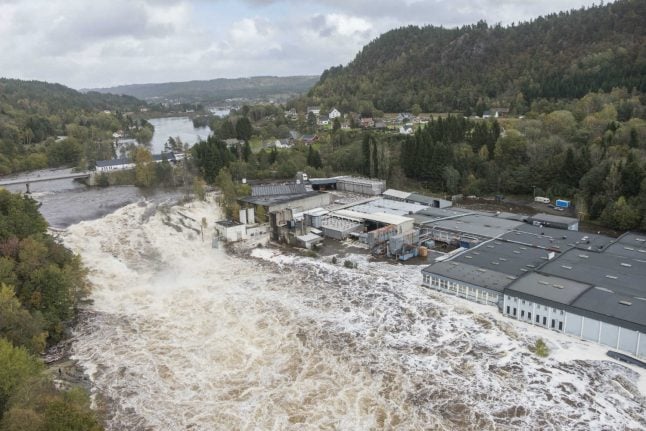
Flooding of the extending currently seen in the region is “extreme and rare,” according to a hydrologist with the Norwegian Water Resources and Energy Directorate (NVE).

“This is something we will see more of in the future,” NVE climate advisor and hydrologist Hege Hisdal told NRK.

Floods now seem to have peaked in water courses in the south and the water will now gradually recede, although it will take several days for larger rivers to return to normal levels, according to the broadcaster’s report.

“An extreme amount of rain has fallen in a relatively short time. The unusual element was a series of low pressure fronts that followed each other with a lot of rain – it has rained a lot over a large area,” Hisdal said.

Some areas have reported the highest water levels since 1900, writes NRK.

“This is very extreme and quite unusual,” Hisdal said, adding that “it is unfortunate that ongoing climate changes increase the probability of this happening.”

While flooding in the affected area of Norway is a natural phenomenon, NVE has observed a significant increase in both temperature and precipitation since the 1900s, Hisdal told NRK.

As such, more flooding as a result of both rainfall and melting snow is likely, she said.

“It is a result of increases in temperature and precipitation, and although we have a had a lot of big floods, including this one, we know that we can expect this again in the future,” Hisdal said.

READ MORE: Not-so-rainy Norwegian city sets record for warm September weather

WEATHER

Denmark records deepest snow level for 13 years

Blizzards in Denmark this week have resulted in the greatest depth of snow measured in the country for 13 years.

Denmark records deepest snow level for 13 years

A half-metre of snow, measured at Hald near East Jutland town Randers, is the deepest to have occurred in Denmark since January 2011, national meteorological agency DMI said.

The measurement was taken by the weather agency at 8am on Thursday.

Around 20-30 centimetres of snow was on the ground across most of northern and eastern Jutland by Thursday, as blizzards peaked resulting in significant disruptions to traffic and transport.

A much greater volume of snow fell in 2011, however, when over 100 centimetres fell on Baltic Sea island Bornholm during a post-Christmas blizzard, which saw as much as 135 centimetres on Bornholm at the end of December 2010.

READ ALSO: Denmark’s January storms could be fourth extreme weather event in three months

With snowfall at its heaviest for over a decade, Wednesday saw a new rainfall record. The 59 millimetres which fell at Svendborg on the island of Funen was the most for a January day in Denmark since 1886. Some 9 weather stations across Funen and Bornholm measured over 50cm of rain.

DMI said that the severe weather now looks to have peaked.

“We do not expect any more weather records to be set in the next 24 hours. But we are looking at some very cold upcoming days,” DMI meteorologist and press spokesperson Herdis Damberg told news wire Ritzau.

SHOW COMMENTS