SHARE
COPY LINK

WEATHER

April snow puts parts of northern France on alert

The winter continues to bite back in northern France with three departments placed on alert for snow on Friday.

April snow puts parts of northern France on alert
File photo of cars stuck in the snow storm that hit France in the middle of march. More snow is due in Normandy on Friday. Photo: AFP

The clocks may have already gone forward but winter weather returned to parts of Normandy overnight forcing the country’s weather service to put the departments of Calvados, l'Orne and l'Eure on “orange” alert – the second highest level of warning.

The winter of 2012/13 has gone down as one of the harshest to hit France in recent memory after breaking several records.

Meteo France revealed earlier this month that several towns in northern and western France recorded their coldest start to spring since records began. Throughout March the average temperature across the north of France was 1.5 degrees colder than normal.

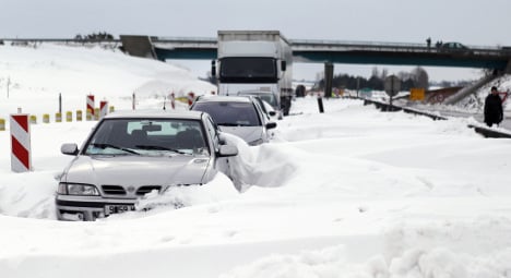
Residents of Normandy will be relieved to hear however that the snow falls forecast will be “nothing compared to” the winter storm that brought the region to a standstill in the middle of March.

Around 15 cm of snow is expected this time around far less than the metre high drifts that resulted in hundreds of motorists getting stranded in their cars and power cuts to thousands of homes.

Member comments

Log in here to leave a comment.
Become a Member to leave a comment.

WEATHER

Denmark records deepest snow level for 13 years

Blizzards in Denmark this week have resulted in the greatest depth of snow measured in the country for 13 years.

Denmark records deepest snow level for 13 years

A half-metre of snow, measured at Hald near East Jutland town Randers, is the deepest to have occurred in Denmark since January 2011, national meteorological agency DMI said.

The measurement was taken by the weather agency at 8am on Thursday.

Around 20-30 centimetres of snow was on the ground across most of northern and eastern Jutland by Thursday, as blizzards peaked resulting in significant disruptions to traffic and transport.

A much greater volume of snow fell in 2011, however, when over 100 centimetres fell on Baltic Sea island Bornholm during a post-Christmas blizzard, which saw as much as 135 centimetres on Bornholm at the end of December 2010.

READ ALSO: Denmark’s January storms could be fourth extreme weather event in three months

With snowfall at its heaviest for over a decade, Wednesday saw a new rainfall record. The 59 millimetres which fell at Svendborg on the island of Funen was the most for a January day in Denmark since 1886. Some 9 weather stations across Funen and Bornholm measured over 50cm of rain.

DMI said that the severe weather now looks to have peaked.

“We do not expect any more weather records to be set in the next 24 hours. But we are looking at some very cold upcoming days,” DMI meteorologist and press spokesperson Herdis Damberg told news wire Ritzau.

SHOW COMMENTS