SHARE
COPY LINK

WEATHER

Snow warnings for northern and central France as winter weather arrives

After snow fell over much of France Monday morning, several départements were placed on the "yellow" weather warning as the country expects more winter weather later in the week.

Snow warnings for northern and central France as winter weather arrives
The Val Thorens French resort on its opening day on November 26, 2022. (Photo by JEFF PACHOUD / AFP)

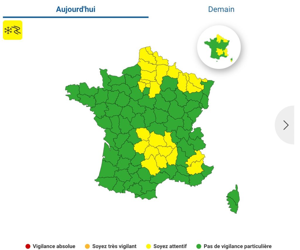
Winter weather has made its way to France. On Monday, Météo-France placed 24 departments under the “yellow” warning on Monday, over snow and ice. 

The départements concerned were primarily located in France’s north, north-east, and centre.

Screenshot from Météo France

Snowflakes made their appearance in Hauts de France and the Paris region on Monday morning, with a few centimetres accumulated in the Grand-Est region. 

In Lozere, significant snowfall on Monday left several motorists blocked in traffic on the A75. 

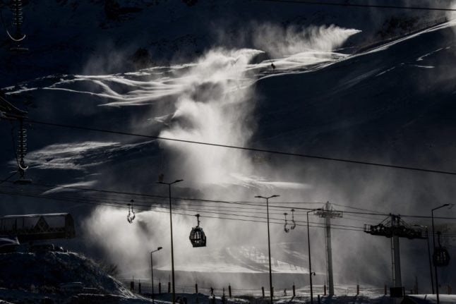
Ski season opened at several resorts, such as the high-altitude Val Thorens resort, in the French Alps this weekend.

As of Monday morning, six of France’s mountainous departments, from Haute-Savoie to Alpes-Maritimes were placed on the “yellow” (be aware) alert for avalanches on Monday.

Where snow is expected later this week

According to BFMTV, the remainder of the week will be marked by dry, cold weather across much of the northern parts of France, but the snowflakes are likely to return over the weekend, from Friday through Sunday.

Météo France expects temperatures to be colder than average this week, by about 4 to 5C chillier than seasonal norms.

Snowfall may begin on Friday morning, starting in France’s east and centre, particularly in the Oise and Cher départements. Later in the evening, light snowflakes are expected to fall on the départements north of the Seine and as far east as Alsace, particularly impacting Ille-et-Vilaine, Mayenne, Orne, Sarthe, Maine-et-Loire and Indre-et-Loire could also be affected.

Over the weekend, about two thirds of the northern part of the country will get to see some flurries, and by Sunday morning, a large northeast quarter of France could have a dusting of snow over the ground before higher temperatures turn the snow to rain later in the day.

Member comments

Log in here to leave a comment.
Become a Member to leave a comment.
For members

ENVIRONMENT

How likely are droughts and water restrictions in France in summer 2024?

Much of France has faced severe flooding this winter, but other areas already face water restrictions, and there's an extra variable in store global weather patterns play their part

How likely are droughts and water restrictions in France in summer 2024?

France’s Bureau de Recherches Géologiques et Minières (BRGM) most recent report, in early March, revealed that the water table in France was ‘satisfactory over a large part of the country’, with levels above normal for the time of year in 46 percent of the country’s underground aquifers.

It warned at the time, however, that levels were low to very low in parts of Alsace, as well as in the Saône corridor and areas of Languedoc, from the south of the Massif Central to the coast, and the Roussillon area of southwest France.

March, too, was a wet month across the bulk of France – it was the fifth wettest since records began in 1958, according to national forecaster Météo-France.

Crucially however, most of the rain falling on the ground in France now will be gobbled up by vegetation, which means that very little water will make it through to aquifers. The groundwater recharge period, when underground water tables are refilled, is now over until late autumn 2024.

Basically, the water table is about as high as it’s going to get this summer.

Which brings us back to the weather.

Long-range forecasts are notoriously inaccurate but after a mild, wet winter, forecasters expect another dry, warm summer overall, following a cooler-than-normal and occasionally wet spring.

April, for example, is set to be marked by cool spells, though, for the April-May-June quarter as a whole, temperatures are expected to remain above seasonal averages. Forecasters warn that a higher-than-usual number of Spring storms could affect the south-east of the country.

Long-range models suggest, however, that June could be hot and dry, with consequences for agriculture – though groundwater levels should be high enough to cope comfortably.

Forecasting further into the summer is even less certain than normal because – over in the Pacific – El Nino is expected to be replaced by La Nina much faster than normal, making weather prediction difficult. 

The consensus is, however, that the cooling effect of La Nina will not be felt until much later in the year. That said, it will have a more immediate effect on weather activity in the North Atlantic. Forecasters are already predicting a record-breaking hurricane season – which will have an effect on French weather patterns.

Between May and July, forecast temperatures in France are likely to remain 1C to 2C above seasonal averages. Precipitation is expected to be fairly close to average, with a tendency for thunderstorms, especially in the south.

Forecast models predict a wet end to April, a fine and dry May, a hot and occasionally thundery June, and a warmer-than-normal July punctuated by thunderstorms – though some forecasts suggest more mixed weather in the north in the seventh month.

With water tables currently well recharged, the national water situation for the summer is, right now, giving experts little cause for concern. 

Thunderstorms are expected to provide occasional watering to limit surface drought, which is always possible even if water tables are well recharged. The summer of 2024 therefore looks set to be different from recent droughts. 

However, this is not to say water restrictions are not impossible, or even unlikely. In certain areas, notably the Aude and Pyrénées-Orientales, where rainfall has been well below average for years, the situation is already serious.

While the rest of the country saw high rainfall in March, these two départements were recording 50 percent less rain than normal.

These areas are already facing a range of water restrictions. To find out whether restrictions are in place where you live, consult the Vigieau website, which offers information on a national, regional and local level.

SHOW COMMENTS