SHARE
COPY LINK

WEATHER

What to expect as France braces for three-day ‘heat dome’

Experts predict temperature records to fall as a well-known weather phenomenon forms over France - bringing highs more usually associated with July and August than mid-May. Here's what to expect.

What to expect as France braces for three-day 'heat dome'
(Photo: Philippe Huguen / AFP)

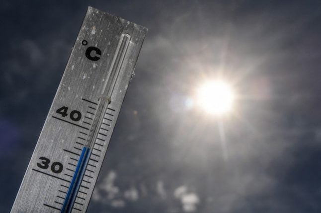
France basked in a late Spring heatwave last week, with temperatures topping 30C in parts of the country for the first time this year.

Now, as we enter the third week in May, forecasters are predicting that temperature records could tumble as a heat dome forms over the country.

Last week was hot, there’s no doubt, but not record-breaking – with higher figures recorded for the month in 1976, 1992, and 1998. But experts say even those highs could fall this week as a mass of hot air moves into France from the south – bringing temperatures more usually associated with July and August.

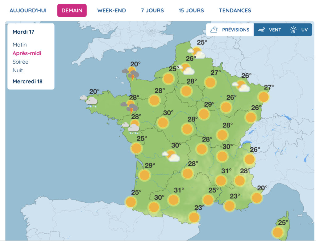
Temperatures over the weekend were already between 8C and 10C above average for the time of year – but, after a brief lull on Monday, they are set to intensify between Tuesday, May 17th, and Thursday, May 19th, as a so-called “heat dome” settles over the country. 

Weather forecast for Tuesday afternoon. Screengrab from MétéoFrance.

A heat dome occurs when the atmospheric pressure acts like a lid and traps warm air from the ocean. This trapped mass of warm ocean air produces a “dome,” like a lid on a microwave meal, inside which temperatures rise. 

The phenomenon, which occurs mainly in spring and summer, is intensified by global warming, and contributes to the increasingly high temperatures recorded year after year. It can cause, in the worst cases, droughts and forest fires.

The mercury will pass 30C across most of the country in the middle of the week, and is expected to soar beyond 35C in the south. High humidity levels mean that it may feel closer to 40C in the south west, and may lead to storms.

There will be some respite overnight, but temperatures are not expected to drop much below 20C in larger cities.

Despite the high temperatures, France’s “plan canicule” will probably not be activated this time in any department or region. 

Average temperatures across France have to cross 30 to 35C during the day and 18 to 20C at night for three consecutive days to trigger the plan – and storms are forecast across a large part of the country on Friday, pushing cooler air down from the north.

Member comments

Log in here to leave a comment.
Become a Member to leave a comment.
For members

ENVIRONMENT

How likely are droughts and water restrictions in France in summer 2024?

Much of France has faced severe flooding this winter, but other areas already face water restrictions, and there's an extra variable in store global weather patterns play their part

How likely are droughts and water restrictions in France in summer 2024?

France’s Bureau de Recherches Géologiques et Minières (BRGM) most recent report, in early March, revealed that the water table in France was ‘satisfactory over a large part of the country’, with levels above normal for the time of year in 46 percent of the country’s underground aquifers.

It warned at the time, however, that levels were low to very low in parts of Alsace, as well as in the Saône corridor and areas of Languedoc, from the south of the Massif Central to the coast, and the Roussillon area of southwest France.

March, too, was a wet month across the bulk of France – it was the fifth wettest since records began in 1958, according to national forecaster Météo-France.

Crucially however, most of the rain falling on the ground in France now will be gobbled up by vegetation, which means that very little water will make it through to aquifers. The groundwater recharge period, when underground water tables are refilled, is now over until late autumn 2024.

Basically, the water table is about as high as it’s going to get this summer.

Which brings us back to the weather.

Long-range forecasts are notoriously inaccurate but after a mild, wet winter, forecasters expect another dry, warm summer overall, following a cooler-than-normal and occasionally wet spring.

April, for example, is set to be marked by cool spells, though, for the April-May-June quarter as a whole, temperatures are expected to remain above seasonal averages. Forecasters warn that a higher-than-usual number of Spring storms could affect the south-east of the country.

Long-range models suggest, however, that June could be hot and dry, with consequences for agriculture – though groundwater levels should be high enough to cope comfortably.

Forecasting further into the summer is even less certain than normal because – over in the Pacific – El Nino is expected to be replaced by La Nina much faster than normal, making weather prediction difficult. 

The consensus is, however, that the cooling effect of La Nina will not be felt until much later in the year. That said, it will have a more immediate effect on weather activity in the North Atlantic. Forecasters are already predicting a record-breaking hurricane season – which will have an effect on French weather patterns.

Between May and July, forecast temperatures in France are likely to remain 1C to 2C above seasonal averages. Precipitation is expected to be fairly close to average, with a tendency for thunderstorms, especially in the south.

Forecast models predict a wet end to April, a fine and dry May, a hot and occasionally thundery June, and a warmer-than-normal July punctuated by thunderstorms – though some forecasts suggest more mixed weather in the north in the seventh month.

With water tables currently well recharged, the national water situation for the summer is, right now, giving experts little cause for concern. 

Thunderstorms are expected to provide occasional watering to limit surface drought, which is always possible even if water tables are well recharged. The summer of 2024 therefore looks set to be different from recent droughts. 

However, this is not to say water restrictions are not impossible, or even unlikely. In certain areas, notably the Aude and Pyrénées-Orientales, where rainfall has been well below average for years, the situation is already serious.

While the rest of the country saw high rainfall in March, these two départements were recording 50 percent less rain than normal.

These areas are already facing a range of water restrictions. To find out whether restrictions are in place where you live, consult the Vigieau website, which offers information on a national, regional and local level.

SHOW COMMENTS