SHARE
COPY LINK

CLIMATE

Glacial 1991 day in Greenland belatedly sets Arctic cold record

A new cold record in the Northern Hemisphere of -69.6 degrees Celsius (-93.2 Fahrenheit) was set on December 22nd, 1991, in Greenland, the Danish Meteorological Institute announced Wednesday, 28 years after the fact.

Glacial 1991 day in Greenland belatedly sets Arctic cold record
File photo: Linda Kastrup/Ritzau Scanpix

The temperature, recorded at a weather station outside of the usual network, was exhumed by “climate detectives” who later had it confirmed by the World Meteorological Organisation. 

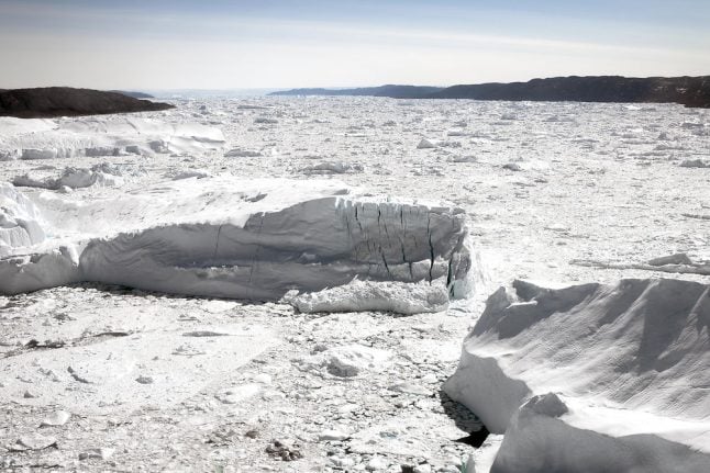
“The record was registered at an altitude of 3,105 metres, near the topographical summit of the icecap, at an automatic test station called Klinck,” DMI said in a statement.

“There have been a lot of heat records in the last decade and it's important to recognise the extremes,” DMI climatologist John Cappelen told AFP.

“The possibility of getting a cold record is lower and lower but I cannot say that it won't happen anymore,” he added.

The previous record low in the Northern Hemisphere was -67.8 Celsius,  registered in Russia on two occasions, in 1892 and 1933.

The lowest temperature ever recorded in the world is -89.2 Celsius, at the Vostok high altitude weather station in the Antarctic, set on July 21st, 1983.

READ ALSO: Climate change sends melting Greenland ice 'past tipping point'

Member comments

Log in here to leave a comment.
Become a Member to leave a comment.

CLIMATE

Central and southern Italy brace for storms and heavy snow

Storms and snowfall are forecast across much of central and southern Italy over the next few days, according to weather reports.

Snow is forecast in the hills of much of central and southern Italy.
Snow is forecast in the hills of much of central and southern Italy. Photo: Miguel MEDINA / AFP

Italy’s Civil Protection Department on Monday issued ‘orange’ alerts for bad weather along Campania’s Tyrrhenian coastline and the western part of Calabria, while Sicily, Basilicata, Lazio, Molise, Umbria, Abruzzo, central-western Sardinia, and the remaining areas of Campania and Calabria are under a lower-level ‘yellow’ weather warning.

The European Centre for Medium-Range Weather Forecasts is warning Italy’s central-southern regions to prepare for a blast of polar air from the Arctic Circle that will bring heavy snowfall, rain and storms, reports national weather forecaster Il Meteo.

The village of Grotte di Castro in the province of Viterbo, two hours’ drive north of Rome, mountainous parts of Sardinia, and much of the province of Campobasso in the central-eastern region of Molise were already blanketed in snow on Monday morning.

The department is responsible for predicting, preventing and managing emergency events across the country, and uses a green, yellow, orange and red graded colour coding system for weather safety reports.

An orange alert signifies a heavy rainfall, landslide and flood risk, while a yellow alert warns of localised heavy and potentially dangerous rainfall.

The current meteorological conditions mean that snow is expected to reach unusually low altitudes of around 450-500 metres, with flakes already falling thickly on parts of the southern-central Apennines mountain range at 500-700 metres altitude.

The hills of Marche, Abruzzo, Molise, Lazio, Sardinia, Campania, Calabria and Basilicata are likely to see heavy snow around the 500m mark, while areas at an altitude of 1000m or higher will see between 50-60 cm of fresh snow.

Affected parts of the country could see 50-60cm of snowfall.

Affected parts of the country could see 50-60cm of snowfall. Photo: Vincenzo PINTO /AFP

In areas where the snow is unlikely to reach, heavy rains and thunderstorms are anticipated, with rain forecast throughout Sardinia, Campania, Calabria and Lazio, reports Il Meteo.

Strong winds are forecast over the whole country, with the island regions of Sicily and Sardinia facing windspeeds of over 100km/hour and the risk of storm surges, according to the national newspaper La Repubblica.

READ ALSO: Climate crisis: The Italian cities worst affected by flooding and heatwaves

The north of the country, meanwhile, will see sun but low temperatures of below 0°C at night in many areas, including across much of the Po Valley.

While conditions are expected to stabilise on Tuesday, cold currents from Northern Europe are forecast to trigger another wave of bad weather on Wednesday and Thursday, with Sardinia and Italy’s western coastline again at risk of storms and heavy rainfall that will move up towards Lombardy, Emilia Romagna and Veneto in the north.

SHOW COMMENTS