SHARE
COPY LINK

WEATHER

In pictures: Eiffel Tower struck by lightning as storms hit Paris

The Iron Lady was hit by lightning on Wednesday during a spring storm in Paris. Here's a look at the moment in pictures and what's on the horizon for the weather in France over the coming days.

In pictures: Eiffel Tower struck by lightning as storms hit Paris
Photo: Bertrand Kulik/Flickr

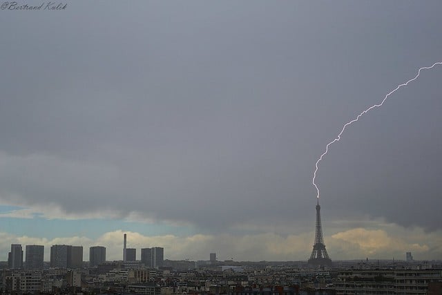
The moment the bolt of lightning hit the iconic Paris monument was captured by photographer Bertrand Kulik (see below). 


The Eiffel Tower is the tallest building in Paris and is regularly hit by lightning, with the monument receiving around four to five strikes a year.
 
This isn't the first time such dramatic scenes have been witnessed in the French capital and elsewhere across France during the month of May. 
 
Last year France's national weather agency Méteo France said that the country experienced the most lightning strikes making contact with the earth since the year 2000.
 
More storms are set to hit France on Thursday in the Hauts-de-France region in the north while rain will hit much of the rest of the country, according to Meteo France. 
 
Meanwhile on Friday the storms will hit Occitanie right in the south of France as temperatures and conditions start to improve across most of the country. 
 
From Monday next week, the weather will seem more pleasantly springlike, with sunshine predicted across most of France and the mercury set to rise from Wednesday. 
 
French words to know:
 
Weather – la météo 
 
Eiffel Tower – la Tour Eiffel
 
Lightning – la foudre
 
Storm – un orage

Member comments

Log in here to leave a comment.
Become a Member to leave a comment.

WEATHER

Denmark records deepest snow level for 13 years

Blizzards in Denmark this week have resulted in the greatest depth of snow measured in the country for 13 years.

Denmark records deepest snow level for 13 years

A half-metre of snow, measured at Hald near East Jutland town Randers, is the deepest to have occurred in Denmark since January 2011, national meteorological agency DMI said.

The measurement was taken by the weather agency at 8am on Thursday.

Around 20-30 centimetres of snow was on the ground across most of northern and eastern Jutland by Thursday, as blizzards peaked resulting in significant disruptions to traffic and transport.

A much greater volume of snow fell in 2011, however, when over 100 centimetres fell on Baltic Sea island Bornholm during a post-Christmas blizzard, which saw as much as 135 centimetres on Bornholm at the end of December 2010.

READ ALSO: Denmark’s January storms could be fourth extreme weather event in three months

With snowfall at its heaviest for over a decade, Wednesday saw a new rainfall record. The 59 millimetres which fell at Svendborg on the island of Funen was the most for a January day in Denmark since 1886. Some 9 weather stations across Funen and Bornholm measured over 50cm of rain.

DMI said that the severe weather now looks to have peaked.

“We do not expect any more weather records to be set in the next 24 hours. But we are looking at some very cold upcoming days,” DMI meteorologist and press spokesperson Herdis Damberg told news wire Ritzau.

SHOW COMMENTS