SHARE
COPY LINK

WEATHER

Temperature highs of 33C predicted for the week ahead

Germany is in for a mixed bag of weather this week, though temperatures will mostly remain pleasant, hitting up to 33C.

Temperature highs of 33C predicted for the week ahead
A thermometer in Stuttgart with the sun in the background. Photo: DPA

The German Weather Service (DWD) reports that sea air entering Germany will warm up under high atmospheric pressure and subtropical warm air will spread over the south and southwest over this week.

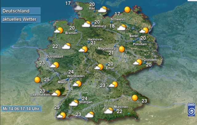
DWD predictions for Wednesday.

It'll be time to don your t-shirts on Thursday, which is expected to be this week's star of the show temperature-wise. In most places it will be lightly cloudy, sunny and dry.

Temperatures will reach 20C-25C by the coast, elsewhere they will lie between 26C and 30C. Areas along the Rhine will enjoy the warmest temperatures, with a high of 32C predicted. The east of the country will remain dry, but individual showers will develop during the afternoon in the southwest, and in the evening in the west and northwest.

There will be powerful thunderstorms and even hail in very southern areas, south of the Danube river, during the night. 

Friday will not be as pleasant as the previous day, bringing changeable weather and heavy clouds in the north and east. Here, as well as in eastern alpine areas, there will be showers and small, isolated thunderstorms. The sun will show itself most often in the southwest and south of the country. Temperatures will fall slightly and sit between 16C and 24C, or up to 26C in southwest.

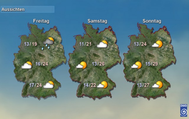
DWD predictions for Friday, Saturday and Sunday.

Like Friday, Saturday is also expected to be changeable and heavily cloudy. The east and southeast will see showers and individual thunderstorms, but these will decrease during the course of the day. Rain will fall in the eastern region of the German Alps. The most sun is to be found in the southwest, where it will also remain dry. Temperatures will increase slightly on the previous day to 17C – 25C, in the southwest up to 27C. 

Sunny and dry weather will prevail on Sunday though, with temperatures warming to 22C-25C in the northeast, 26C-30C elsewhere and the southwest hitting 32C.

This temperature increase will continue at the beginning of next week, with the mercury hitting 33C in parts of the country on Monday. 

June 20th will see temperatures between 28C and 33C with a mixture of sunshine and cloud and isolated thunderstorms in the afternoon. 


WEATHER

Winter weather returns to Germany after spring heat spell

Temperatures in Germany almost hit 30C in the last few weeks. But winter-like weather is well and truly back - and ski slopes are even re-opening in some areas.

Winter weather returns to Germany after spring heat spell

Many people in Germany will have already packed away their winter clothes as spring has seen high temperatures and lots of sun.

But a cosy hoody and jacket will be needed again.

According to the German Weather Service (DWD), a blast of polar air has been moving in bringing ice, rain and sleet that is turning to snow, particularly at higher altitudes. 

Those who want to take advantage of the winter weather can even get back on the slopes. Many ski resorts had to close early for the season – but a few are reopening. 

On Friday, the ski lift at Kandel in the Emmendingen district (Baden-Württemberg) opens for floodlit skiing from 6pm. to 10pm. If the snow remains, the lifts will also operate at the weekend from 9am to 5pm.

Meanwhile, the lift at Seebuck (Breisgau-Hochschwarzwald district) is operating on Saturday from 1pm to 5pm.

‘Aprilschmuddelwetter’

Lower-lying spots have also seen hailstones and snow showers. People in Munich dealt with a flurry of snow on Thursday as temperatures fell. High temperatures ranged from 4C in Oberallgäu to 12C in Lower Franconia.

In a post on X, the DWD described it as AprilschmuddelwetterSchmuddelwetter translates to “mucky” or “foul weather” and is often used in Germany in spring when there’s lots of rain.

The DWD said: “April foul weather on Friday: Widespread rain, snow in high mountain areas. In the afternoon, partly heavy sleet showers from the north-west, isolated thunderstorms. In addition, stormy winds in places. Temperatures will barely reach double figures.”

The DWD shared a photo with tulips poking out from the snow in Neuhaus am Rennweg in Thuringia and said it was symbolic of the current weather situation.

The low pressure system moving in from the North Sea was bringing more widespread rain, thunderstorms and hail on Friday. 

In Berlin temperatures hovered around 7C on Friday during the day with continuous rain. It was around 5C in Erfurt and 8C in Kiel. 

In western Germany, it was slightly less cool with temperatures reaching 10C – but torrential rain was forecast. 

Changeable weather with showers was forecast on Saturday, while some sunshine in the north and east of Germany was expected on Sunday. 

At night, there is a risk of frost, ice and freezing rain in the coming days in spots where the temperature drops.

This comes after a series of storms and strong winds lashed the country earlier this week.

READ ALSO: Storms and high winds hit Germany

Just a few days before that, Germany was bathed in sunshine as temperatures climbed up to nearly 30C.

SHOW COMMENTS