SHARE
COPY LINK

WEATHER

Hail storms, wild fires and heatwave put France on alert

Residents in the south west have been warned about violent storms and hail showers, those in the south face wildfires and in Paris it's the heat that the locals need to be aware of.

Hail storms, wild fires and heatwave put France on alert
Photo: AFP

In all, 11 departments in the south west were placed on Orange alert on Tuesday morning by Météo France with violent storms, featuring hail showers and gales set to sweep through the region.

The departments on orange alert are Vienne, Deux-Sevres, Charente-Maritime, Charente, Dordogne, Gironde, Lot-et-Garonne, Gers, Landes, hautes-Pyrénées, Pyrénées-Atlantique.

“This wave of storms will be marked by a high risk of localised hail storms, violent gusts of wind reaching 80 to 90km/h, possibly passing 100km/h,” reads the warning on Météo France.

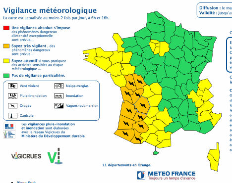
Intense downpours are also predicted with up to 60mm of rainfall forecast in some areas over a short space of time.

The alerts are set to come into place at 2pm on Tuesday and will last until midnight.

Temperatures have been high in the region, including up to 35C in Dordogne, but they will give way to storms throughout the afternoon, which will hit the western end of the Pyrenées mountains first.

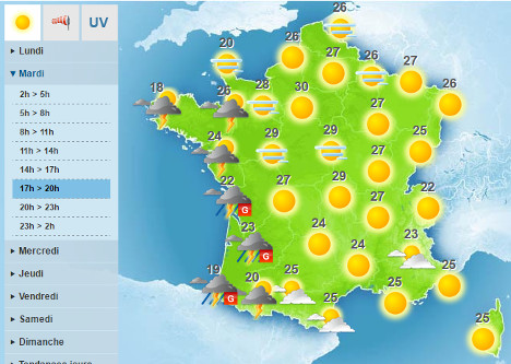
Elsewhere in France it was a different story.

The Ile-de-France region around Paris, was placed on yellow alert – the one below Orange – for a mini-heatwave which will see temperatures sneak into the low 30s on Tuesday.

Forest fires warning in south

Residents in the south of France have also been asked to be on alert for wild fires due to the ongoing high temperatures and lack of rain in the region. High winds have exacerbated the danger.

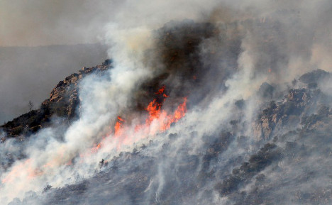
France’s General Direction of Civil Security is asking people to be extremely careful on Tuesday in the departments that lie on the Mediterranean coast, where wildfires have already burned hundreds of hectares of land this summer.

Temperatures are set to fall towards the end of the week as the storms make their way across the country which should herald the arrival of typical autumnal weather.


Member comments

Log in here to leave a comment.
Become a Member to leave a comment.

WEATHER

Denmark records deepest snow level for 13 years

Blizzards in Denmark this week have resulted in the greatest depth of snow measured in the country for 13 years.

Denmark records deepest snow level for 13 years

A half-metre of snow, measured at Hald near East Jutland town Randers, is the deepest to have occurred in Denmark since January 2011, national meteorological agency DMI said.

The measurement was taken by the weather agency at 8am on Thursday.

Around 20-30 centimetres of snow was on the ground across most of northern and eastern Jutland by Thursday, as blizzards peaked resulting in significant disruptions to traffic and transport.

A much greater volume of snow fell in 2011, however, when over 100 centimetres fell on Baltic Sea island Bornholm during a post-Christmas blizzard, which saw as much as 135 centimetres on Bornholm at the end of December 2010.

READ ALSO: Denmark’s January storms could be fourth extreme weather event in three months

With snowfall at its heaviest for over a decade, Wednesday saw a new rainfall record. The 59 millimetres which fell at Svendborg on the island of Funen was the most for a January day in Denmark since 1886. Some 9 weather stations across Funen and Bornholm measured over 50cm of rain.

DMI said that the severe weather now looks to have peaked.

“We do not expect any more weather records to be set in the next 24 hours. But we are looking at some very cold upcoming days,” DMI meteorologist and press spokesperson Herdis Damberg told news wire Ritzau.

SHOW COMMENTS