SHARE
COPY LINK

WEATHER

Violent storms hit Switzerland as planet heats up (again)

Heavy rain, hail and storms are set to batter Switzerland over the next couple of days after a period of intense heat and humidity comes to an end.

Violent storms hit Switzerland as planet heats up (again)
File photo: Benjamin Benson

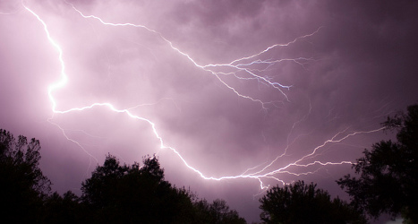
Issuing a weather warning, Meteo Suisse said there was a “marked danger” of violent storms throughout most of the country from now until Saturday.

Storms have already hit in some parts, especially the Jura, which saw “severe thunderstorms” on Thursday night, according to SRF Meteo.

In La Brévine – known for its extreme weather – 33 millimetres of rain fell in two hours, it said.

The storms will cool the country slightly after temperatures rose up to 35C degrees this week.

Much of the country experienced another ‘tropical’ night on the night of Wednesday to Thursday – so-called when temperatures do not fall below 20C degrees during the whole night.

While Switzerland hasn’t so far this year beaten its past record for hot weather, set in 2007, meteorologists have confirmed that, globally, the planet is hotter than ever.

Reporting figures by the National Oceanic and Atmospheric Administration (NOAA), Meteo Suisse said the average global temperature in the first six months of the year was 0.92 degrees above the norm, smashing the previous record, set last year, of 0.71 degrees higher than normal.

The planet’s overall average temperature rose for the 14th consecutive month in June, partly due to the El Niño weather phenomenon in the Pacific which is the third most intense in the last 65 years.


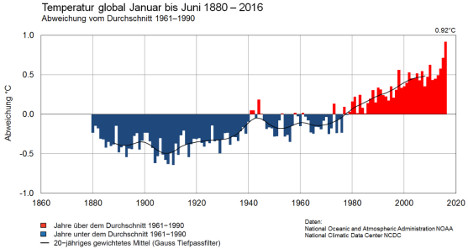
Global temperature from 1880-2016. Source: Meteo Suisse

In Switzerland the average temperature in June was 0.2 degrees above the norm, but it was also the wettest June on record in some parts of the country, according to Meteo Suisse.

Speaking to Le Matin, Vincent Devantay from Meteo News said it was difficult to say why, but that certain climatologists think “global warming can lead to more meteorological phenomena such as intense rainfall”.

“But these are only predictions,” he added.

Deal Gil of Meteo Suisse was more cautious still, saying June is often a “deceiving” time of year.

“We associate it with flowers and the sun, when in reality the weather is often rather gloomy,” he told the paper.

“Our geographical location, halfway between the north pole and the equator, means we have a climate that alternates between hot and cold depending on the air currents.”

That has certainly been reflected in the Swiss summer so far, which has seen periods of intense heat and even snow in some parts.

Member comments

Log in here to leave a comment.
Become a Member to leave a comment.

WEATHER

IN PICTURES: ‘Exceptional’ Sahara dust cloud hits Europe

An "exceptional" dust cloud from the Sahara is choking parts of Europe, the continent's climate monitor said on Monday, causing poor air quality and coating windows and cars in grime.

IN PICTURES: 'Exceptional' Sahara dust cloud hits Europe

Copernicus Atmosphere Monitoring Service said the latest plume, the third of its kind in recent weeks, was bringing hazy conditions to southern Europe and would sweep northward as far as Scandinavia.

Mark Parrington, senior scientist at Copernicus, said the latest event was related to a weather pattern that has brought warmer weather to parts of Europe in recent days.

“While it is not unusual for Saharan dust plumes to reach Europe, there has been an increase in the intensity and frequency of such episodes in recent years, which could be potentially attributed to changes in atmospheric circulation patterns,” he said.

This latest episode has caused air quality to deteriorate in several countries, Copernicus said.

The European Union’s safe threshold for concentrations of PM10 — coarser particles like sand and dust that that can irritate the nose and throat — has already been exceeded in some locations.

A picture taken on April 8, 2024 shows a rapeseed field under thick sand dust blown in from the Sahara, giving the sky a yellowish appearance near Daillens, western Switzerland. – An “exceptional” dust cloud from the Sahara is choking parts of Europe, the continent’s climate monitor said, causing poor air quality and coating windows and cars in grime. (Photo by Fabrice COFFRINI / AFP)

The worst affected was the Iberian Peninsula in Spain but lesser air pollution spikes were also recorded in parts of Switzerland, France and Germany.

READ ALSO:

Local authorities in southeastern and southern France announced that the air pollution threshold was breached on Saturday.

They advised residents to avoid intense physical activity, particularly those with heart or respiratory problems.

The dust outbreak was expected to reach Sweden, Finland and northwest Russia before ending on Tuesday with a shift in weather patterns, Copernicus said.

The Sahara emits between 60 and 200 million tonnes of fine dust every year, which can travel thousands of kilometres (miles), carried by winds and certain meteorological conditions.

The Spanish Canary Islands off the coast of northwest Africa saw just 12 days within a 90-day period from December to February where skies were free of Saharan dust, the local weather agency Aemet had reported.

SHOW COMMENTS