SHARE
COPY LINK

WEATHER

VIDEO: Violent tornado strikes western France

The second tornado in less than a week caused havoc in western France on Wednesday, but experts say the phenomenon is nothing too extreme for that part of the country.

VIDEO: Violent tornado strikes western France
The tornado that ripped through villages in the Charente Maritime was caught on camera. Photo: YouTube/Damian 180888

The latest tornado to hit the Charente Maritime département in western France caused damage in several villages around the town of Saints.

Although no one was hurt the vortex of swirling air caused damage to around 50 buildings.

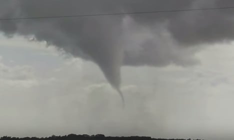
The tornado, which was caught on video by a witness, looks like something you’d expect in the mid-west of America rather on the west coast of France.

However weather experts say we should not be surprised, even if it was the second tornado to strike in a week in the area.

“This is not an exceptional phenomenon,” David Dumas from the French Observatory of tornados and violent storms told TF1.

“The Charente Maritime is a “risk zone”, meaning it’s a region of France where the occurrence of tornados is higher than normal.”

However Dumas said this week’s tornado was the most violent in the area since 2013. 

The video below shows the destruction it left behind.

The tornado struck as violent storms lashed much of central France causing widespread damage and leaving three people dead.

Member comments

Log in here to leave a comment.
Become a Member to leave a comment.

WEATHER

Denmark records deepest snow level for 13 years

Blizzards in Denmark this week have resulted in the greatest depth of snow measured in the country for 13 years.

Denmark records deepest snow level for 13 years

A half-metre of snow, measured at Hald near East Jutland town Randers, is the deepest to have occurred in Denmark since January 2011, national meteorological agency DMI said.

The measurement was taken by the weather agency at 8am on Thursday.

Around 20-30 centimetres of snow was on the ground across most of northern and eastern Jutland by Thursday, as blizzards peaked resulting in significant disruptions to traffic and transport.

A much greater volume of snow fell in 2011, however, when over 100 centimetres fell on Baltic Sea island Bornholm during a post-Christmas blizzard, which saw as much as 135 centimetres on Bornholm at the end of December 2010.

READ ALSO: Denmark’s January storms could be fourth extreme weather event in three months

With snowfall at its heaviest for over a decade, Wednesday saw a new rainfall record. The 59 millimetres which fell at Svendborg on the island of Funen was the most for a January day in Denmark since 1886. Some 9 weather stations across Funen and Bornholm measured over 50cm of rain.

DMI said that the severe weather now looks to have peaked.

“We do not expect any more weather records to be set in the next 24 hours. But we are looking at some very cold upcoming days,” DMI meteorologist and press spokesperson Herdis Damberg told news wire Ritzau.

SHOW COMMENTS