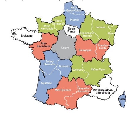
Thousands have protested the changes in the eastern region of Alsace, where the main UMP opposition party is in power.
Local lawmakers there said they would seek to appeal the decision at the Constitutional Court.
Only three regions will be unaffected by the changes: Ile de France that includes Paris and its surrounding areas, Provence-Alpes-Cote d'Azur around Marseille and the island of Corsica.
The changes, championed by President François Hollande, are due to be implemented in January 2016.

The plan dates back decades but has never been implemented until now, partly because divisive rows have sprung up every time it is considered and has has already been changed twice after protests and dissent.
Locals in some regions, such as in the eastern region of Alsace near the German border which would join the nearby Lorraine and Champagne-Ardennes regions, argue that a merger would affect their regional identity too much. While others, such as in the area around Bordeaux, have welcomed the move since it will turn it into one big wine-producing region merging three current ones.
Some regions also squabble about which regional city should be the capital of the new entity. A similar big region around the eastern city of Lyon has also been welcomed.
France has had the same municipal map since the 18th century.


 Please whitelist us to continue reading.
Member comments