SHARE
COPY LINK

TRAVEL

Whitsun weekend offers sunshine and traffic jams

The Whitsun (Pfingsten) long weekend should be glorious, with clear skies and temperatures of 20 to 27 degrees Celsius predicted for most of Germany, national weather service the DWD reported on Friday.

Whitsun weekend offers sunshine and traffic jams
Photo: DPA

Showers should stay away, with a small possibility of light drizzle in the south on Monday, and although the west is expected to see the highest temperatures, a large high-pressure front should guarantee warm weather throughout the country.

There should even be a cool breeze in coastal and mountain areas to offer some relief from the heat.

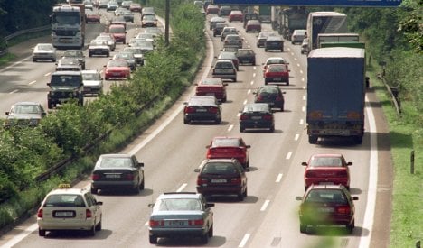
Many Germans are expected to take advantage of the balmy conditions and head away for a short break, so some traffic on the roads is inevitable.

Routes heading south are expected to be busy, with the German Automobile Club (ADAC) warning of delays for those travelling to Austria, Switzerland and the Italian lakes.

Those on the way north to soak up the sun on the North Sea or Baltic coasts should fare better, but popular coastal roads may see heavy traffic, an ADAC traffic expert told The Local.

There’s better news for international travellers as many connections between Germany with eastern Europe have been improved, as have several main roads in the Czech Republic and Serbia.

The ADAC said travellers should either head off early on Saturday morning, or wait until Sunday afternoon, when the roads are expected to be at their quietest.

Whitsun vacationers should also beware of the possibility of forest fires. Although the wind is expected to drop over the weekend, a warning remains in place on account of the exceptional dryness. The alert level is current at its highest rating in Saxony and Brandenburg.

Below is a list of the routes expected to be particularly congested, according to regional newspaper the Kölner Stadt-Anzeiger:

• A 1 Köln – Bremen – Hamburg – Lübeck

• A 3 Köln – Frankfurt – Nürnberg

• A 5 Frankfurt – Karlsruhe – Basel

• A 6 Mannheim – Heilbronn – Nürnberg

• A 7 Würzburg – Füssen

• A 8 Karlsruhe – Stuttgart – München – Salzburg

• A 9 Berlin – Nürnberg – München

• A 19 Wittstock – Rostock

• A 24 Berlin – Hamburg

• A 81 Stuttgart – Singen

• A 93 Inntaldreieck – Kufstein

• A 99 Umfahrung München

DWD/The Local/jpg

Member comments

Log in here to leave a comment.
Become a Member to leave a comment.

WEATHER

Winter weather returns to Germany after spring heat spell

Temperatures in Germany almost hit 30C in the last few weeks. But winter-like weather is well and truly back - and ski slopes are even re-opening in some areas.

Winter weather returns to Germany after spring heat spell

Many people in Germany will have already packed away their winter clothes as spring has seen high temperatures and lots of sun.

But a cosy hoody and jacket will be needed again.

According to the German Weather Service (DWD), a blast of polar air has been moving in bringing ice, rain and sleet that is turning to snow, particularly at higher altitudes. 

Those who want to take advantage of the winter weather can even get back on the slopes. Many ski resorts had to close early for the season – but a few are reopening. 

On Friday, the ski lift at Kandel in the Emmendingen district (Baden-Württemberg) opens for floodlit skiing from 6pm. to 10pm. If the snow remains, the lifts will also operate at the weekend from 9am to 5pm.

Meanwhile, the lift at Seebuck (Breisgau-Hochschwarzwald district) is operating on Saturday from 1pm to 5pm.

‘Aprilschmuddelwetter’

Lower-lying spots have also seen hailstones and snow showers. People in Munich dealt with a flurry of snow on Thursday as temperatures fell. High temperatures ranged from 4C in Oberallgäu to 12C in Lower Franconia.

In a post on X, the DWD described it as AprilschmuddelwetterSchmuddelwetter translates to “mucky” or “foul weather” and is often used in Germany in spring when there’s lots of rain.

The DWD said: “April foul weather on Friday: Widespread rain, snow in high mountain areas. In the afternoon, partly heavy sleet showers from the north-west, isolated thunderstorms. In addition, stormy winds in places. Temperatures will barely reach double figures.”

The DWD shared a photo with tulips poking out from the snow in Neuhaus am Rennweg in Thuringia and said it was symbolic of the current weather situation.

The low pressure system moving in from the North Sea was bringing more widespread rain, thunderstorms and hail on Friday. 

In Berlin temperatures hovered around 7C on Friday during the day with continuous rain. It was around 5C in Erfurt and 8C in Kiel. 

In western Germany, it was slightly less cool with temperatures reaching 10C – but torrential rain was forecast. 

Changeable weather with showers was forecast on Saturday, while some sunshine in the north and east of Germany was expected on Sunday. 

At night, there is a risk of frost, ice and freezing rain in the coming days in spots where the temperature drops.

This comes after a series of storms and strong winds lashed the country earlier this week.

READ ALSO: Storms and high winds hit Germany

Just a few days before that, Germany was bathed in sunshine as temperatures climbed up to nearly 30C.

SHOW COMMENTS