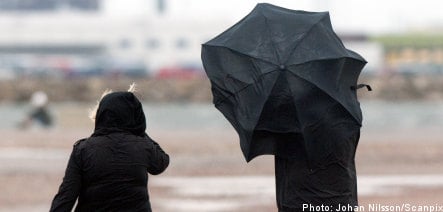
“There will be a complete storm on the North Sea and then, the night to Wednesday, we will see gale force winds in all of Götaland. There is a risk of more trees falling,” said Åsa Rasmussen, meteorologist for Sveriges Television (SVT) on Monday.
The Swedish Meteorological and Hydrological Institute, SMHI, is preparing to issue warnings for the coming storm.
“There’ll be warnings, but we don’t issue these until 24 hours before something is expected to happen, so they are yet to come,” said Lisa Frost, forecaster at SMHI to news agency TT on Monday afternoon.
She is expecting warnings to be issued during Monday evening or during the night to Tuesday.
“My guess is that there will be a Class 1 warning for Götaland, but for parts of the west coast and down towards Skåne, I think it will be a Class 2 warning,” said Frost to TT.
But Danish forecasters are more worried about the readings.
“It is a very strong low pressure area, which can be best described as an ‘atmospheric bomb’ as the pressure drops so suddenly. We’re talking of gale force winds up to 35-40 metres per second,” said Danish meteorologist Andreas Nyholm to Danish paper Ekstrabladet.
However, Nyholm doesn’t think that the storm will hit Scandinavia with the same force that Dagmar did. He is joined in that opinion by Frost at SMHI.
Sweden has not had winds as strong as those recorded during recent weeks for years.
“Some of our stations measured the strongest winds in at least 15 years,” said Andersson to DN.
Between Christmas and New Year the weather calmed down slightly in the wake of storm Dagmar but by then northern parts of the country had suffered extensive forest damage caused by the strong winds.
The National Board of Forestry (Skogsstyrelsen) has been taking stock of damages done to Swedish woods over the Christmas period and while work continues it has to do so with more bad weather en route for Sweden.
“We hope to have some preliminary figures ready this week,” Johanna From, regional director at the agency told TT.
The Swedish National Railway (Statens Järnvägar, SJ) is also still working at establishing the extent of the damages done to its network in the aftermath of the storms.

Member comments