The weather has caused a number of road accidents throughout the country and all long-distance train traffic to and from Stockholm’s Central Station has been interrupted since 2pm local time after a widespread signal failure at Älvjsö.
SL commuter train traffic is also affected by the stoppage. The interrupted is expected to be resolved shortly.
“The stop affects both southbound and northbound traffic. There are no trains at all between Stuvsta and Sundbyberg,” said Tobbe Lundell, press officer at the Swedish Transport Administration (Trafikverket).
A power failure is reported to have caused the error signal. SL has put in extra buses between Älvsjö and Liljeholmen.
Sweden’s meteorological office SMHI has issued a class 2 (on an ascending scale of 3) weather warning for Gotland, Södermanland, Stockholm, Roslagen and the Gävleborg coast.
Snowfall is expected to continue through the night until Friday morning and is also forecast for western Sweden and southern Norrland.
Several accidents have taken place in the storm’s path. Östergötland reported 12 accidents by lunchtime, but there have been no serious injuries. According to the Östgöta-Correspondenten online, conditions are very slippery.
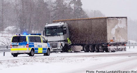
In Södermanland, the weather has caused a number of accidents on the E4.
Around Örebro, several traffic accidents were reported in a short time period.
“It has become really troublesome there. It is snowing heavily and has become slippery,” said Anna Ekberg at the command centre in Stockholm.
The agency went into “enhanced operational management” in the Stockholm area before the snowfall. As such, there is increased preparedness to perform snow clearance as quickly as possible to keep roads and railways open.
“We are following the weather situation very closely throughout the day to cope with any possible storms,” said Anna Hanson of the agency.
The central region, which includes Dalarna, Gävleborg, Jämtland and Västernorrland, has also increased preparedness. However, the problems are not expected to be as extensive.
In western Sweden, precipitation is mainly falling in the form of rain or wet snow. In the east, there is a risk of snowdrifts on the roads as the snowfall combines with fresh winds of up to 15 metres per second.
The low-pressure area will remain until Friday morning before moving eastward.
“However, eastern Svealand and northern Götaland should count on snow throughout tomorrow morning,” said Elin Torstensson, meteorologist at SMHI.
Snow has fallen in western areas through the night and a warning has been issued for icy roads in the Gothenburg area. Up to 15 centimetres of wet snow are expected during the day.
The snow is expected to turn into rain during the day as temperatures climb towards and above zero.
Some minor traffic accidents have been reported around Gothenburg on Thursday, reported the local Göteborgs-Posten daily.
SMHI has also forecast snow falls for southern Norrland and has issued a lesser class 1 warning for Götaland, Örebro and Värmland counties.
Windy weather has been forecast for Thursday evening for the coasts of Svealand and southern Norrland.
Temperatures have plunged during the night, dropping to below -30 degrees Celsius in several places in northern Sweden. Nikkaluokta in the far north recorded as low as -37.
The cold temperatures are expected to stay over the weekend, with clear skies and little precipitation expected.
Member comments